Turn on suggestions
Auto-suggest helps you quickly narrow down your search results by suggesting possible matches as you type.
Cancel
- Home
- :
- All Communities
- :
- Developers
- :
- ArcObjects SDK (Retired)
- :
- ArcObjects SDK Questions
- :
- [C#] How to create Line of Sight?
Options
- Subscribe to RSS Feed
- Mark Topic as New
- Mark Topic as Read
- Float this Topic for Current User
- Bookmark
- Subscribe
- Mute
- Printer Friendly Page
03-27-2013
03:42 AM
- Mark as New
- Bookmark
- Subscribe
- Mute
- Subscribe to RSS Feed
- Permalink
Hello
I'm able to load a DTED Level 0 file into a RasterDataset, color it and create a IRasterLayer from it to add into axMapControl. Here is my working code:
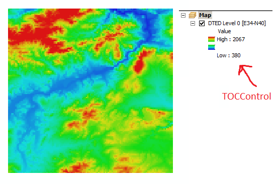
The result is this screenshot of axMapControl:[ATTACH=CONFIG]22980[/ATTACH]
Now, I want to create Line of Sight; between observer and a point. How can I do that? I have no idea unfortunately.
Thanks
I'm able to load a DTED Level 0 file into a RasterDataset, color it and create a IRasterLayer from it to add into axMapControl. Here is my working code:
IWorkspaceFactory wsf = new RasterWorkspaceFactoryClass(); IRasterWorkspace rasterWS = (IRasterWorkspace)wsf.OpenFromFile(@"C:\Users\ABC\Desktop\DTED_E30N40\dted\e034", 0); rasterDS = rasterWS.OpenRasterDataset("n40.dt0"); IRasterBandCollection pRasterBandCollection = (IRasterBandCollection)rasterDS; IEnumRasterBand pEnumRasterBand = pRasterBandCollection.Bands; IRasterBand pRasterBand = pEnumRasterBand.Next(); pRasterBand.ComputeStatsAndHist(); IRasterStatistics pRasterStatistics = pRasterBand.Statistics; IRgbColor pFromColor = new RgbColorClass(); pFromColor.Red = 20; pFromColor.Green = 20; pFromColor.Blue = 220; IRgbColor pToColor = new RgbColorClass(); pToColor.Red = 220; pToColor.Green = 20; pToColor.Blue = 20; IAlgorithmicColorRamp pAlgorithmicColorRamp = new AlgorithmicColorRampClass(); pAlgorithmicColorRamp.FromColor = pFromColor; pAlgorithmicColorRamp.ToColor = pToColor; pAlgorithmicColorRamp.Algorithm = esriColorRampAlgorithm.esriHSVAlgorithm; pAlgorithmicColorRamp.Size = 255; bool bOK; pAlgorithmicColorRamp.CreateRamp(out bOK); IRasterStretchColorRampRenderer pRasterStretchColorRampRenderer = new RasterStretchColorRampRendererClass(); pRasterStretchColorRampRenderer.BandIndex = 0; pRasterStretchColorRampRenderer.LabelHigh = pRasterStatistics.Maximum.ToString(); pRasterStretchColorRampRenderer.LabelLow = pRasterStatistics.Minimum.ToString(); pRasterStretchColorRampRenderer.ColorRamp = pAlgorithmicColorRamp; IRasterLayer rasterLayer = new RasterLayer(); rasterLayer.CreateFromDataset(rasterDS); rasterLayer.Name = "DTED Level 0 [E34-N40]"; rasterLayer.Renderer = (IRasterRenderer)pRasterStretchColorRampRenderer; axMapControl1.AddLayer(rasterLayer);The result is this screenshot of axMapControl:[ATTACH=CONFIG]22980[/ATTACH]
Now, I want to create Line of Sight; between observer and a point. How can I do that? I have no idea unfortunately.
Thanks
Solved! Go to Solution.
1 Solution
Accepted Solutions
03-27-2013
06:14 AM
- Mark as New
- Bookmark
- Subscribe
- Mute
- Subscribe to RSS Feed
- Permalink
Lines of sight can be calculated by calling ISurface.GetLineOfSight.
And there you have it :D.
This has some implementation details you might be interested in:
http://forums.esri.com/Thread.asp?c=93&f=993&t=192554
11 Replies
03-27-2013
03:46 AM
- Mark as New
- Bookmark
- Subscribe
- Mute
- Subscribe to RSS Feed
- Permalink
By the way, I found this class: LineOfSight Class
but I don't have ESRI.ArcGIS.Analyst3DTools namespace. Why?
I don't either have ESRI.ArcGIS.SpatialAnalystTools to use ViewShed Class.
Any idea about adding these namespaces?
Sincerely
but I don't have ESRI.ArcGIS.Analyst3DTools namespace. Why?
I don't either have ESRI.ArcGIS.SpatialAnalystTools to use ViewShed Class.
Any idea about adding these namespaces?
Sincerely
03-27-2013
04:38 AM
- Mark as New
- Bookmark
- Subscribe
- Mute
- Subscribe to RSS Feed
- Permalink
By the way, I found this class: LineOfSight Class
but I don't have ESRI.ArcGIS.Analyst3DTools namespace. Why?
I don't either have ESRI.ArcGIS.SpatialAnalystTools to use ViewShed Class.
Any idea about adding these namespaces?
Sincerely
You have to add a reference to Analyst3DTools to your project.
1) Right-click References in your project
2) Click Add Reference
3) Select the .NET tab
4) Select ESRI.ArcGIS.Analyst3DTools
5) Click OK
Do the same for ESRI.ArcGIS.SpatialAnalysisTools.
03-27-2013
04:55 AM
- Mark as New
- Bookmark
- Subscribe
- Mute
- Subscribe to RSS Feed
- Permalink
You have to add a reference to Analyst3DTools to your project.
1) Right-click References in your project
2) Click Add Reference
3) Select the .NET tab
4) Select ESRI.ArcGIS.Analyst3DTools
5) Click OK
Thank you very much for your reply.
Well, do you have any idea about using LineOfSight or ViewShed class? How to set observer and point?
By the way, both namespaces (ESRI.ArcGIS.Analyst3DTools & ESRI.ArcGIS.SpatialAnalysisTools) has ViewShed class. I'll use Analyst3DTools' class.
Thank again 🙂
03-27-2013
05:14 AM
- Mark as New
- Bookmark
- Subscribe
- Mute
- Subscribe to RSS Feed
- Permalink
Thank you very much for your reply.
Well, do you have any idea about using LineOfSight or ViewShed class? How to set observer and point?
By the way, both namespaces (ESRI.ArcGIS.Analyst3DTools & ESRI.ArcGIS.SpatialAnalysisTools) has ViewShed class. I'll use Analyst3DTools' class.
Thank again 🙂
I don't think I fully understand what you are trying to do. The classes you mention seem to be for use in ArcGlobe, but you mentioned AxMapControl, which I think is for use in ArcMap. I'm new to ArcGIS, so those might be bad assumptions. Can you post a picture of what you're trying to accomplish?
03-27-2013
05:28 AM
- Mark as New
- Bookmark
- Subscribe
- Mute
- Subscribe to RSS Feed
- Permalink
Well, you are right 😄
After a lot of googling, I found out that I need "Linear Line of Sight", based on my DTED data. You can see the screenshot I posted earlier. How can I get linear Line of Sight between two points?
Thanks
After a lot of googling, I found out that I need "Linear Line of Sight", based on my DTED data. You can see the screenshot I posted earlier. How can I get linear Line of Sight between two points?
Thanks
03-27-2013
05:59 AM
- Mark as New
- Bookmark
- Subscribe
- Mute
- Subscribe to RSS Feed
- Permalink
Well, you are right 😄
After a lot of googling, I found out that I need "Linear Line of Sight", based on my DTED data. You can see the screenshot I posted earlier. How can I get linear Line of Sight between two points?
Thanks
Unfortunately, all I've been able to find is the Military Analyst extension, which I think is for ArcGlobe: http://webhelp.esri.com/arcgisdesktop/9.3/index.cfm?TopicName=Using_the_Linear_Line_of_Sight
If you have licenses for ArcGlobe and Military Analyst, I would use them.
I haven't seen any API for calculating LLOS in ArcMap, but that doesn't mean it doesn't exist. I'm sure custom code can be written to do this, but I can't promise I'd have enough time to help you very much with writing it.
03-27-2013
06:09 AM
- Mark as New
- Bookmark
- Subscribe
- Mute
- Subscribe to RSS Feed
- Permalink
Lines of sight can be calculated by calling ISurface.GetLineOfSight.
03-27-2013
06:14 AM
- Mark as New
- Bookmark
- Subscribe
- Mute
- Subscribe to RSS Feed
- Permalink
Lines of sight can be calculated by calling ISurface.GetLineOfSight.
And there you have it :D.
This has some implementation details you might be interested in:
http://forums.esri.com/Thread.asp?c=93&f=993&t=192554
03-27-2013
09:41 AM
- Mark as New
- Bookmark
- Subscribe
- Mute
- Subscribe to RSS Feed
- Permalink
And there you have it :D.
This has some implementation details you might be interested in:
http://forums.esri.com/Thread.asp?c=93&f=993&t=192554
Thank you very much Neil; for mentioning ISurface and thank you ScJpike; for your helpful link 🙂
Now, I'm able to get linear line of sight of two points, as you see: [ATTACH=CONFIG]23004[/ATTACH]
Well, is there any way to give observer's Z (elevation) and get line of sight of that point with given Z (not the elevation in DTED)? Imagine that I want to get LLOS of a helicopter that abviously it's elevation is greater that DTED's elevation of that point.
Or it's only possible with DTED elevations? Any idea?
Thank you very much guys
Sincerely