Turn on suggestions
Auto-suggest helps you quickly narrow down your search results by suggesting possible matches as you type.
Cancel
- Home
- :
- All Communities
- :
- Developers
- :
- ArcObjects SDK (Retired)
- :
- ArcObjects SDK Questions
- :
- Re: Buffering using VBA
Options
- Subscribe to RSS Feed
- Mark Topic as New
- Mark Topic as Read
- Float this Topic for Current User
- Bookmark
- Subscribe
- Mute
- Printer Friendly Page
Buffering using VBA
Subscribe
4896
8
10-30-2013 06:48 PM
10-30-2013
06:48 PM
- Mark as New
- Bookmark
- Subscribe
- Mute
- Subscribe to RSS Feed
- Permalink
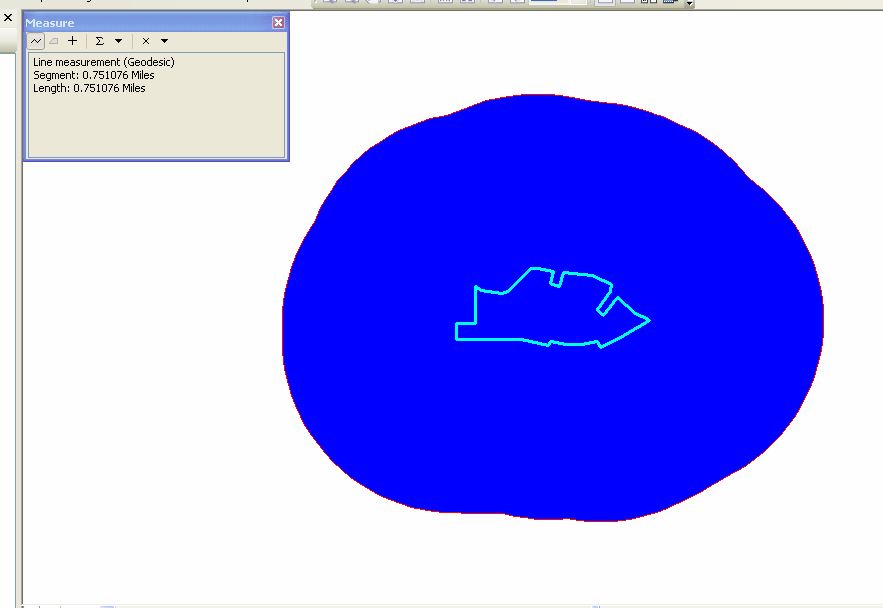
I am using the following code to draw a 1 mile buffer around a polygon. When I measure the distance from the edge of the polygon to the buffer, its not accurate. North and South are fine, but East and West are off.
Dim pMxDoc As IMxDocument
Dim pActiveView As IActiveView
Dim pGraphicsContainer As IGraphicsContainer
Dim pEnumFeature As IEnumFeature
Dim pFeature As IFeature
Dim pTopoOp As ITopologicalOperator
Dim pElement As IElement
Dim strBufferDistance As String
Set pMxDoc = Application.Document
Set pActiveView = pMxDoc.FocusMap
Set pGraphicsContainer = pMxDoc.FocusMap
'Verify there is a feature selection
If pMxDoc.FocusMap.SelectionCount = 0 Then Exit Sub
'Get a buffer distance from the user
strBufferDistance = InputBox("Enter Distance:", "Buffer")
If strBufferDistance = "" Or Not IsNumeric(strBufferDistance) Then Exit Sub
'Buffer all the selected features by the BufferDistance
'and create a new polygon element from each result
Set pEnumFeature = pMxDoc.FocusMap.FeatureSelection
pEnumFeature.Reset
Set pFeature = pEnumFeature.Next
Do While Not pFeature Is Nothing
Set pTopoOp = pFeature.Shape
Set pElement = New PolygonElement
pElement.Geometry = pTopoOp.Buffer(CInt(strBufferDistance))
pGraphicsContainer.AddElement pElement, 0
Set pFeature = pEnumFeature.Next
Loop
'Redraw the graphics
8 Replies
10-31-2013
05:23 AM
- Mark as New
- Bookmark
- Subscribe
- Mute
- Subscribe to RSS Feed
- Permalink
I notice that you aren't giving your graphic element a spatial reference. Without a spatial reference defined, it's quite possible that ArcMap will not properly project the element. Have you determined that this is not a spatial reference issue? I've been using ITopoOp.Buffer for over a decade and have never had any problems with it.
10-31-2013
01:16 PM
- Mark as New
- Bookmark
- Subscribe
- Mute
- Subscribe to RSS Feed
- Permalink
If you're using the measure tool, check what type of distance it's returning. A problem with east-west distances implies to me that the geodesic distance is being returned.
Melita
Melita
11-04-2013
03:38 PM
- Mark as New
- Bookmark
- Subscribe
- Mute
- Subscribe to RSS Feed
- Permalink
I notice that you aren't giving your graphic element a spatial reference. Without a spatial reference defined, it's quite possible that ArcMap will not properly project the element. Have you determined that this is not a spatial reference issue? I've been using ITopoOp.Buffer for over a decade and have never had any problems with it.
Modified my code to the following, but still it doesn't work. When I measure the distance using the measuring tool, E is 0.75 miles and W is 0.78 miles, but N and S returns 1 mile.
Dim pMxDoc As IMxDocument
Dim pxMap As IMap
Dim pActiveView As IActiveView
Dim pGraphicsContainer As IGraphicsContainer
Dim pEnumFeature As IEnumFeature
Dim pFeature As iFeature
Dim pTopoOp As ITopologicalOperator
Dim pElement As IElement
Dim strBufferDistance As String
Set pMxDoc = ThisDocument
Set pxMap = pMxDoc.FocusMap
Dim pSpatRefFact As ISpatialReferenceFactory
Set pSpatRefFact = New SpatialReferenceEnvironment
Dim pspatref As ISpatialReference
Set pspatref = pSpatRefFact.CreateESRISpatialReferenceFromPRJFile("NAD83.prj")
Set pxMap.SpatialReference = pspatref
Set pActiveView = pxMap
Set pGraphicsContainer = pMxDoc.FocusMap
'Verify there is a feature selection
If pMxDoc.FocusMap.SelectionCount = 0 Then Exit Sub
Set pEnumFeature = pMxDoc.FocusMap.FeatureSelection
pEnumFeature.Reset
Set pFeature = pEnumFeature.Next
Do While Not pFeature Is Nothing
Set pTopoOp = pFeature.Shape
Set pElement = New PolygonElement
pElement.Geometry = pTopoOp.Buffer(ConvertUnits(1#, esriMiles, esriDecimalDegrees))
pGraphicsContainer.AddElement pElement, 0
Set pFeature = pEnumFeature.Next
Loop
'Redraw the graphics
pActiveView.PartialRefresh esriViewGraphics, Nothing, Nothing
11-04-2013
03:38 PM
- Mark as New
- Bookmark
- Subscribe
- Mute
- Subscribe to RSS Feed
- Permalink
If you're using the measure tool, check what type of distance it's returning. A problem with east-west distances implies to me that the geodesic distance is being returned.
Melita
It returns me in miles.
11-05-2013
09:16 AM
- Mark as New
- Bookmark
- Subscribe
- Mute
- Subscribe to RSS Feed
- Permalink
The geodesic distance is the distance on the ellipsoid/spheroid. It will be in linear units like miles or meters.
The ConvertUnits is making an assumption to convert miles to degrees, probably using a mile at the equator to calculate the equivalent length in degrees. When you check that with the measure tool, the fact that the meridians (longitude lines) converge toward the pole means that the east-west distance is shorter than the north-south distance. My guess, based on the difference in the lengths, is that the data is at approximately 41 North latitude.
Melita
11-07-2013
04:18 AM
- Mark as New
- Bookmark
- Subscribe
- Mute
- Subscribe to RSS Feed
- Permalink
You should reread Melita's last post. Your screenshots clearly indicate you are looking at the geodesic distance.
11-07-2013
06:10 PM
- Mark as New
- Bookmark
- Subscribe
- Mute
- Subscribe to RSS Feed
- Permalink
Once I switched to the right Projection (UTM) it worked. Thanks for your replies.