- Home
- :
- All Communities
- :
- Developers
- :
- ArcObjects SDK (Retired)
- :
- ArcObjects SDK Questions
- :
- Add IFeatureLayer from FeatureServer
- Subscribe to RSS Feed
- Mark Topic as New
- Mark Topic as Read
- Float this Topic for Current User
- Bookmark
- Subscribe
- Mute
- Printer Friendly Page
- Mark as New
- Bookmark
- Subscribe
- Mute
- Subscribe to RSS Feed
- Permalink
Hello,
I'm trying to load a IFeatureLayer from a FeatureServer in a ArcGIS Engine 10.3 Application, but I always get a "System.Runtime.InteropServices.COMException" Error Message. (Line is marked with an Error Comment).
What is the Problem of getting the Layers from the Server?
Thank You very much for your help.
Public Shared Function GetAGSFeatureLayer(ByVal sURL As String) As IFeatureLayer
Dim pAGSConnectionFactory As IAGSServerConnectionFactory
Dim pConnectionProps As IPropertySet
Dim pAGSConnection As IAGSServerConnection
Dim enumServerObjectName As IAGSEnumServerObjectName
Dim pServerObjectName As IAGSServerObjectName3
Dim pName As IName
Dim pObject As Object
Dim pServerSymbolOutputOptions As IServerSymbolOutputOptions
Dim pGraphicFeatureLayers As IGraphicFeatureLayers
Dim pGraphicFeatureLayer As IGraphicFeatureLayer2
Dim pGraphicFeatureServer As IGraphicFeatureServer
Try
pConnectionProps = New PropertySet
pConnectionProps.SetProperty("URL", sURL)
pAGSConnectionFactory = New AGSServerConnectionFactory
pAGSConnection = pAGSConnectionFactory.Open(pConnectionProps, 0)
enumServerObjectName = pAGSConnection.ServerObjectNames
enumServerObjectName.Reset()
pServerObjectName = enumServerObjectName.Next
Do Until pServerObjectName Is Nothing
If pServerObjectName.Type.Equals("FeatureServer", StringComparison.OrdinalIgnoreCase) Then
pName = pServerObjectName
pObject = pName.Open
If TypeOf pObject Is IGraphicFeatureServer Then
pServerSymbolOutputOptions = New ServerSymbolOutputOptions
pServerSymbolOutputOptions.ConvertLabelExpressions = False
pServerSymbolOutputOptions.PictureOutputType = esriServerPictureOutputType.esriServerPictureOutputAsPNG
pGraphicFeatureServer = pObject
pGraphicFeatureLayers = pGraphicFeatureServer.GetLayers(pServerSymbolOutputOptions) 'ERROR
If pGraphicFeatureLayers.Count > 0 Then
For i As Integer = 0 To pGraphicFeatureLayers.Count - 1
pGraphicFeatureLayer = pGraphicFeatureLayers.Element(i)
If TypeOf pGraphicFeatureLayer Is IFeatureLayer Then
Return pGraphicFeatureLayer
End If
Next
End If
End If
End If
pServerObjectName = enumServerObjectName.Next
Loop
Catch ex As Exception
logger.Error("GetAGSFeatureLayer", ex)
End Try
Return Nothing
End Function
Solved! Go to Solution.
Accepted Solutions
- Mark as New
- Bookmark
- Subscribe
- Mute
- Subscribe to RSS Feed
- Permalink
Got it:
Snippet
Public Shared Function GetAGSFeatureLayer(ByVal sURL As String) As IFeatureLayer
   Dim pAGSConnectionFactory As IAGSServerConnectionFactory
   Dim pConnectionProps As IPropertySet
   Dim pAGSConnection As IAGSServerConnection
   Dim enumServerObjectName As IAGSEnumServerObjectName
   Dim pServerObjectName As IAGSServerObjectName3
   Dim pLayerFactory As ILayerFactory
   Dim pEnumLayer As IEnumLayer
   Dim pLayer As ILayer
   Dim pCurrentLayer As ILayer
   Dim pCompositeLayer As ICompositeLayer
   Try
      pConnectionProps = New PropertySet
      pConnectionProps.SetProperty("URL", sURL)
      pAGSConnectionFactory = New AGSServerConnectionFactory
      pAGSConnection = pAGSConnectionFactory.Open(pConnectionProps, 0)
      enumServerObjectName = pAGSConnection.ServerObjectNames
      enumServerObjectName.Reset()
      pServerObjectName = enumServerObjectName.Next
      Do Until pServerObjectName Is Nothing
         If pServerObjectName.Type.Equals("FeatureServer", StringComparison.OrdinalIgnoreCase) Then
            pLayerFactory = New FeatureServerLayerFactory
            pEnumLayer = pLayerFactory.Create(pServerObjectName)
            pLayer = pEnumLayer.Next()
            Do Until pLayer Is Nothing
               If TypeOf pLayer Is ICompositeLayer Then
                  pCompositeLayer = pLayer
                  For i As Integer = 0 To pCompositeLayer.Count - 1
                     pCurrentLayer = pCompositeLayer.Layer(i)
                     If TypeOf pCurrentLayer Is IFeatureLayer Then
                        Return DirectCast(pCurrentLayer, IFeatureLayer)
                     End If
                  Next
               End If
               pLayer = pEnumLayer.Next()
            Loop
         End If
         pServerObjectName = enumServerObjectName.Next
      Loop
   Catch ex As Exception
      logger.Error("GetAGSFeatureLayer", ex)
   End Try
   Return Nothing
End Function
- Mark as New
- Bookmark
- Subscribe
- Mute
- Subscribe to RSS Feed
- Permalink
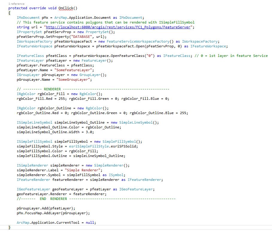
The code sample here below shows how to add a feature service to ArcMap using ArcObjects (click on the image below to enlarge the image):
- Mark as New
- Bookmark
- Subscribe
- Mute
- Subscribe to RSS Feed
- Permalink
Thank you, very much, but in your example you create your own new layer.
Isn't it possible to get the layer with it's symbology/renderer from the Feature-Service?
- Mark as New
- Bookmark
- Subscribe
- Mute
- Subscribe to RSS Feed
- Permalink
Mickey,
Yes, that is correct. I do create my own new layer to add to ArcMap. One would definitely need an instance of a new layer object to hold the properties of the incoming feature service data, so there is definitely a need to create that new layer.
However, in order to symbolize and display that new layer the exact same way it was being displayed on the server (and I believe this is your question), you would simply not assign a renderer to it. Thus, in the code I provided earlier, all you'd have to do is to comment out the "renderer" part of the code. This should allow the display of the layer in its "original" form. In this case, the original renderer that was used for the feature service layer on the server (the REST endpoint) would automatically be utilized by ArcMap to render the layer.
- Mark as New
- Bookmark
- Subscribe
- Mute
- Subscribe to RSS Feed
- Permalink
Hello Sami,
thank you, that's what I was looking for. But there are two more things I need to know:
If I load a Feature Service in ArcMap, the Layers have Layernames which are the Name of the Feature-Class in their SDE. In ArcObjects the FC-Names are Numbers. Furthermore the Layer have set a minimum scale.
Where do I find the FC-Name and minimum Scale in ArcObjects?
- Mark as New
- Bookmark
- Subscribe
- Mute
- Subscribe to RSS Feed
- Permalink
The feature class name can be accessed via the IFeatureClass.AliasName property:
http://resources.arcgis.com/en/help/arcobjects-net/componenthelp/index.html#//0025000002qs000000
The layer's minimum scale may be accessed via the ILayer.MinimumScale property:
http://resources.arcgis.com/en/help/arcobjects-net/componenthelp/index.html#//0012000006z1000000
A good book on ArcObjects development that you might find useful is Beginning ArcGIS for Desktop Development using .NET, by Pouria Amirian (2013).
- Mark as New
- Bookmark
- Subscribe
- Mute
- Subscribe to RSS Feed
- Permalink
Sorry, my english is not very good, maybe you didn't understand me right:
I'm writing an ArcGIS Engine Application which should load Feature-Services the same way as ArcMap. And if I load a Feature-Service in ArcMap, ArcMap creates Layers with a Layername, a Symbology and a minimum scale.
Now If I use your code from above in my ArcGIS Engine App, I only have a Feature-Class. The name and the alias-name of this Feature-Class is a number (e.g. 0). And if I create a new Layer and set the datasource, the Layer has no minimum scale.
So, my question is: how does ArcMap gets the Layername and minimum scale from the Feature-Service? Your code from above does not answer this question.
Thank you very much.
- Mark as New
- Bookmark
- Subscribe
- Mute
- Subscribe to RSS Feed
- Permalink
Any suggestions so far?
- Mark as New
- Bookmark
- Subscribe
- Mute
- Subscribe to RSS Feed
- Permalink
Got it:
Snippet
Public Shared Function GetAGSFeatureLayer(ByVal sURL As String) As IFeatureLayer
   Dim pAGSConnectionFactory As IAGSServerConnectionFactory
   Dim pConnectionProps As IPropertySet
   Dim pAGSConnection As IAGSServerConnection
   Dim enumServerObjectName As IAGSEnumServerObjectName
   Dim pServerObjectName As IAGSServerObjectName3
   Dim pLayerFactory As ILayerFactory
   Dim pEnumLayer As IEnumLayer
   Dim pLayer As ILayer
   Dim pCurrentLayer As ILayer
   Dim pCompositeLayer As ICompositeLayer
   Try
      pConnectionProps = New PropertySet
      pConnectionProps.SetProperty("URL", sURL)
      pAGSConnectionFactory = New AGSServerConnectionFactory
      pAGSConnection = pAGSConnectionFactory.Open(pConnectionProps, 0)
      enumServerObjectName = pAGSConnection.ServerObjectNames
      enumServerObjectName.Reset()
      pServerObjectName = enumServerObjectName.Next
      Do Until pServerObjectName Is Nothing
         If pServerObjectName.Type.Equals("FeatureServer", StringComparison.OrdinalIgnoreCase) Then
            pLayerFactory = New FeatureServerLayerFactory
            pEnumLayer = pLayerFactory.Create(pServerObjectName)
            pLayer = pEnumLayer.Next()
            Do Until pLayer Is Nothing
               If TypeOf pLayer Is ICompositeLayer Then
                  pCompositeLayer = pLayer
                  For i As Integer = 0 To pCompositeLayer.Count - 1
                     pCurrentLayer = pCompositeLayer.Layer(i)
                     If TypeOf pCurrentLayer Is IFeatureLayer Then
                        Return DirectCast(pCurrentLayer, IFeatureLayer)
                     End If
                  Next
               End If
               pLayer = pEnumLayer.Next()
            Loop
         End If
         pServerObjectName = enumServerObjectName.Next
      Loop
   Catch ex As Exception
      logger.Error("GetAGSFeatureLayer", ex)
   End Try
   Return Nothing
End Function