- Home
- :
- All Communities
- :
- Developers
- :
- ArcObjects SDK (Retired)
- :
- ArcObjects SDK Questions
- :
- Re: Add .dwg file to Map using Code
- Subscribe to RSS Feed
- Mark Topic as New
- Mark Topic as Read
- Float this Topic for Current User
- Bookmark
- Subscribe
- Mute
- Printer Friendly Page
Add .dwg file to Map using Code
- Mark as New
- Bookmark
- Subscribe
- Mute
- Subscribe to RSS Feed
- Permalink
One of our customers have thousands of CAD .dwg files. The need an function on the Web that they can provide a .dwg file name, and get an .PDF file.
Export to PDF from .mxd or .lyr file is quite easy. The problem is how to make an .mxd or .lyr file from a .dwg file.
Of cause I can using ArcMap, add .dwg file using the Add Data Dialog. As I learn from the Desktop Help:
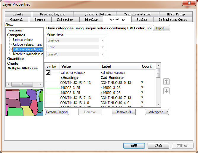
"When you add CAD data to a map document, features are drawn to match the CAD drawing's original symbology as closely as possible. The default CAD renderer draws CAD features by unique values combining line type, color, and line weight properties."
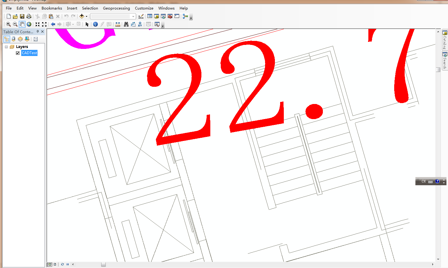
And I got a map like this, it's pretty good:
The problem is we need to automate the process. so we using the flowing code to add the Cad Drawing to the Map:
Set pCadDrawingDataset = GetCadDataset("d:\data\cad", "e-51878.dwg")
If pCadDrawingDataset Is Nothing Then Exit Sub
Set pCadLayer = New CadLayer
Set pCadLayer.CadDrawingDataset = pCadDrawingDataset
pCadLayer.Name = "e-51878.dwg"
pMxDoc.FocusMap.AddLayer pCadLayer
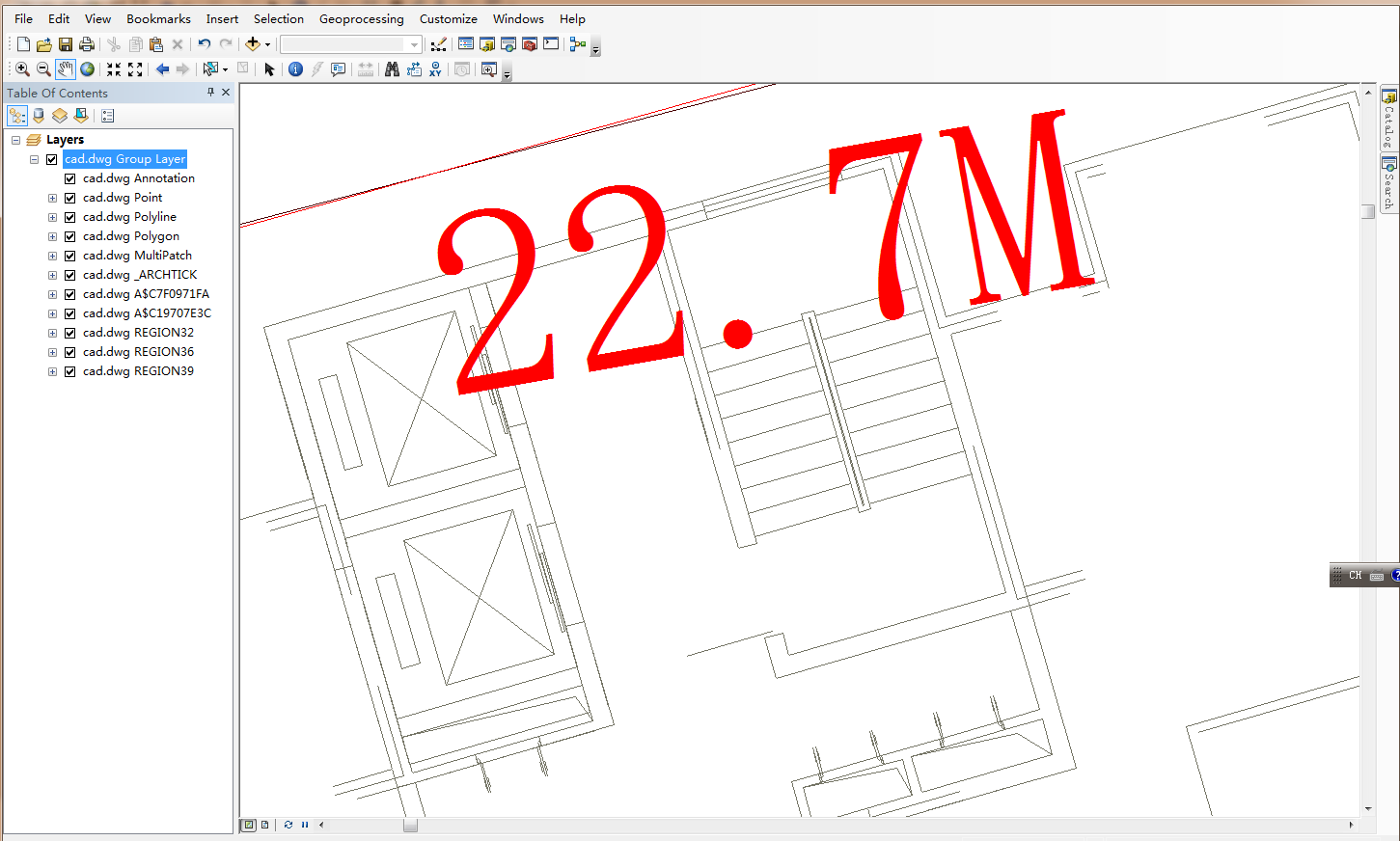
It works, but the map looked like this:
The line color is OK, but the Annotation is too big compares the the first image, and the whole dwg file becomes one layer. Since it is become one layer, we can not modify the display of the annotation.
Of cause we can add the .dwg layer by layer using .dwg:polyline, .dwg:polygon. But this method can not do the automatic symbolization.
So my question is : Is it possible to do the "Add Data to Map" by the ArcObjects Code? So that I can get the first map. I know there is a IAddDataDialog, but it will popup an dialog.
ArcMap using a special renderer for CAD .dwg file, it is very difficult to do it in Code:
- Mark as New
- Bookmark
- Subscribe
- Mute
- Subscribe to RSS Feed
- Permalink
I guest the best way is to add may be 10-20 .dwg files one time in ArcMap using the Add Data, then save each .dwg group layer to .lyr file using python code; keep doing it until we create a .lyr file for each .dwg file. Thus the .lyr files will have the renderer information of the .dwg files. Finally we can use AO or Python to export PDF using the exist .lyr file, get the right symbol and annotation.
- Mark as New
- Bookmark
- Subscribe
- Mute
- Subscribe to RSS Feed
- Permalink
I searched the document and find that we can drop the .dwg file from a Catlog window instead of using the "Add Data" button:
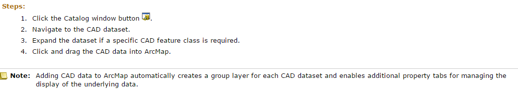
This method also creates a group layer, can we automate this process by ArcObjects code? Thanks a lot.
- Mark as New
- Bookmark
- Subscribe
- Mute
- Subscribe to RSS Feed
- Permalink
On the subject of the annotation changing size.
Does the input CAD file have a known projection? normally this would mean you have a prj file next to the CAD with the same basename.
- Mark as New
- Bookmark
- Subscribe
- Mute
- Subscribe to RSS Feed
- Permalink
Thanks for the reply.
The CAD files do not have any projection files, it is come from other agency who only use the AutoCAD.
- Mark as New
- Bookmark
- Subscribe
- Mute
- Subscribe to RSS Feed
- Permalink
Well that probably explains why the annotation changes size.
- Mark as New
- Bookmark
- Subscribe
- Mute
- Subscribe to RSS Feed
- Permalink
Yes, That could be the reason for the annotation. But the annotation works well when adding the .dwg using the "Add Data" button in ArcMap. Seems the "Add Data" using better mechanism to show the CAD data. That is why we want simulate that process in Code.
- Mark as New
- Bookmark
- Subscribe
- Mute
- Subscribe to RSS Feed
- Permalink
I was looking for a solution for exactly the same requirement as described in this thread. Though it is an old thread, it may help someone. The solution is given below.
Public Sub AddCADLayer2GroupLayer(pGrpLayer As IGroupLayer, cadFolderPath As String, cadfilename As String)
Dim pFeatureLayer As ESRI.ArcGIS.Carto.IFeatureLayer = Nothing
Dim factory As IWorkspaceFactory = New CadWorkspaceFactory
Dim pFeatureWorkspace As IFeatureWorkspace = CType(factory.OpenFromFile(cadFolderPath, 0), IFeatureWorkspace)
Dim pFeatureDataset As IFeatureDataset = CType(pFeatureWorkspace.OpenFeatureDataset(cadfilename), IFeatureDataset)
Dim pFeatureClassContainer As IFeatureClassContainer = CType(pFeatureDataset, IFeatureClassContainer)
For i As Integer = 0 To pFeatureClassContainer.ClassCount - 1
Dim pFeatureClass As IFeatureClass = pFeatureClassContainer.Class(i)
If pFeatureClass.FeatureType = esriFeatureType.esriFTAnnotation Or pFeatureClass.FeatureType = esriFeatureType.esriFTCoverageAnnotation Then
pFeatureLayer = New CadAnnotationLayerClass
pFeatureLayer.Name = pFeatureClass.AliasName
pFeatureLayer.FeatureClass = pFeatureClass
Else
pFeatureLayer = New CadFeatureLayer
pFeatureLayer.Name = pFeatureClass.AliasName
pFeatureLayer.FeatureClass = pFeatureClass
Dim iglayer As ESRI.ArcGIS.Carto.IGeoFeatureLayer = CType(pFeatureLayer, ESRI.ArcGIS.Carto.IGeoFeatureLayer)
'Here the Renderer is set
Dim pUID As New UID ' create a new UID objects
'progID is "esriCartoUI.CadUniqueValuePropertyPage"
pUID.Value = "esriCartoUI.CadUniqueValuePropertyPage"
iglayer.RendererPropertyPageClassID = pUID
End If
If pFeatureLayer IsNot Nothing Then
pGrpLayer.Add(pFeatureLayer)
End If
Next
End Sub