- Home
- :
- All Communities
- :
- Products
- :
- ArcMap (Retired)
- :
- ArcMap Questions
- :
- Translate excel-function to raster calculator/ fie...
- Subscribe to RSS Feed
- Mark Topic as New
- Mark Topic as Read
- Float this Topic for Current User
- Bookmark
- Subscribe
- Mute
- Printer Friendly Page
Translate excel-function to raster calculator/ field calculator
- Mark as New
- Bookmark
- Subscribe
- Mute
- Subscribe to RSS Feed
- Permalink
Hey!
I am trying to calculate different raster layers in ArcGIS with a relativly simple formular, but a few more complicated cell relationships. I have already solved the calculation in Microsoft Excel and now have to implement the procedere in GIS.
- Can you suggest a VB or python script ( i am NOT VERY familiar with this) to calculate my excel-based solution within the field calculator / raster calculator? I am looking for a raster-based solution, but i am open for any ideas!
My goal is to calculate different parameter regarding sprinkling of agricultural crop types in times of climate change.
I would like to do the calculation with raster-tools in a batch process, if possible, because for each factor in the formular i got like 180 datasets and around 300.000 cells to calculate with.
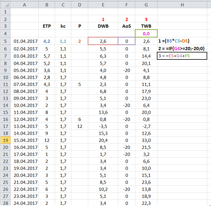
Here are my input-parameters (on a daily basis - all values are in mm (millimeter)):
- Evapotranspiration (ETP) - raster
- Kc-Factor (Kc) - raster
- Precipitation (P) - raster
I have to calculate:
- Daily water balance (DWB) = (ETP*kc)-P
- Total water balance (TWB) = DWB - AoS
- Amount of sprinkling (AoS) = in general, this parameter has the value "0", but it is influenced by the sum of the Total Water Balance. If the sum, of TWB is e.g. >20, >12, >16, ... the AoS is -20, -12, -16 ... --> this actually means, if it is to dry for e.g. the crop type "winter weath" you have to sprinkle 20mm therefor AoS = -20.
You can see the schematic in the following image, this is for an example for single raster cell:
I hope anyone of you has a few ideas.
Cheers in advance!
Jacob