- Home
- :
- All Communities
- :
- Products
- :
- ArcMap
- :
- ArcMap Questions
- :
- Tool for filling a basin from a given point to a c...
- Subscribe to RSS Feed
- Mark Topic as New
- Mark Topic as Read
- Float this Topic for Current User
- Bookmark
- Subscribe
- Mute
- Printer Friendly Page
- Mark as New
- Bookmark
- Subscribe
- Mute
- Subscribe to RSS Feed
- Permalink
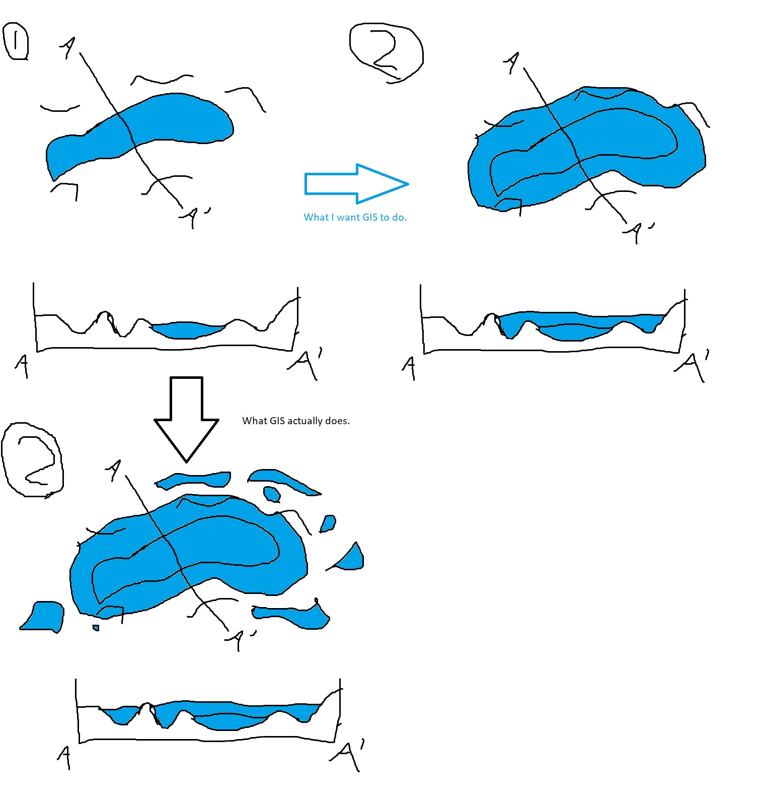
Hello! I'm looking for a tool in ArcGIS Desktop that I can use to fill in a basin on a DEM from a given point (see the attached image). Basically, I'm trying to see how the footprint of a closed basin lake will change as water is added to it. For a while now I've been brute forcing this using contour polygons, then going around the edges of the polygons and erasing all of the areas not connected to the main water body, but this is extremely tedious, and I have a lot of lake levels to look through.
Does anyone know a tool that can fill in a basin from a given point, taking topography into consideration? Bonus points if you know a tool where I can input a volume, and GIS can adjust the lake level and area accordingly!
- Mark as New
- Bookmark
- Subscribe
- Mute
- Subscribe to RSS Feed
- Permalink
You have the spatial analyst extension I presume?
What is the ArcGIS Spatial Analyst extension?—ArcMap | Documentation
and you have looked at...
An overview of the Hydrology toolset—ArcMap | Documentation (arcgis.com)
but it seems you want something clicky that will do it on the fly for a quick preview, or am I wrong?
... sort of retired...
- Mark as New
- Bookmark
- Subscribe
- Mute
- Subscribe to RSS Feed
- Permalink
Hi Dan,
Thanks for the response! I have Spatial Analyst and use the hydrology toolset a lot, but from what I've seen, the hydrology toolset is best for flowing water, not so much for lake levels. I basically need the fill tool, but on a much larger scale (not just on a cell by cell basis, and where I can set the desired elevation to fill to). There's always a chance I'm underutilizing one of the hydrology tools, so please let me know if I'm missing something obvious!
- Mark as New
- Bookmark
- Subscribe
- Mute
- Subscribe to RSS Feed
- Permalink
If you are using Arc Hydro (AH) tools, we have a document "Arc Hydro: Identifying and Managing Sinks" (https://community.esri.com/t5/water-resources-documents/arc-hydro-identifying-and-managing-sinks-pdf...) that goes over a number of different techniques for identifying and then "doing something" with "sinks". Section 3 in that document deals explicitly with identifying sinks. AH has a specific tool "Construct Depression Hierarchy" that identifies nested depressions (using similar technique as you are - with contours) that can help you figure out what is nested within what. And then few additional tools to selectively "fill" what you want to fill. While this might not be the "one button" solution you might be looking for, it might be helpful in getting there. If you are new to AH, doc "Downloading and Installing Arc Hydro Tools" (https://community.esri.com/t5/water-resources-documents/downloading-and-installing-arc-hydro-tools/t...) provides an overview on getting the tools, and https://www.esri.com/en-us/landing-page/industry/water/2020/arc-hydro-gis-for-water-resources is the "home" page for Arc Hydro where you can find links to other AH docs and to water resources Community page where users exchange ideas about AH and water resources in general.
If you find this useful, I can help you with any specific AH questions and we can possibly "stitch" together a workflow based on your specific requirements.
Dean