- Home
- :
- All Communities
- :
- Products
- :
- ArcMap
- :
- ArcMap Questions
- :
- Shp. and TIFF file not fitting in Arcmap 10.4.1
- Subscribe to RSS Feed
- Mark Topic as New
- Mark Topic as Read
- Float this Topic for Current User
- Bookmark
- Subscribe
- Mute
- Printer Friendly Page
Shp. and TIFF file not fitting in Arcmap 10.4.1
- Mark as New
- Bookmark
- Subscribe
- Mute
- Subscribe to RSS Feed
- Permalink
Hello everyone,
I am so sorry if i ask a potential easy to resolve question.
Recently I wanted to open an old project and continue the map, the shape files imported work well together.
In a separate Arcmap window, the TIFF files also work well, importing I get a “no spatial reference” message which I solve using the define projection tool, where I specify the same as the shapes coordinate sytem.
So with a single coordinate system, importing an Arcmap, the shape and TIFF files do not overlap, even though the shapes used to be drawn from the TIFF maps and I would continue to draw them but this is not possible as they are not fitting on each other.
Some advice what i do wrong?
Roland Szalay
Solved! Go to Solution.
Accepted Solutions
- Mark as New
- Bookmark
- Subscribe
- Mute
- Subscribe to RSS Feed
- Permalink
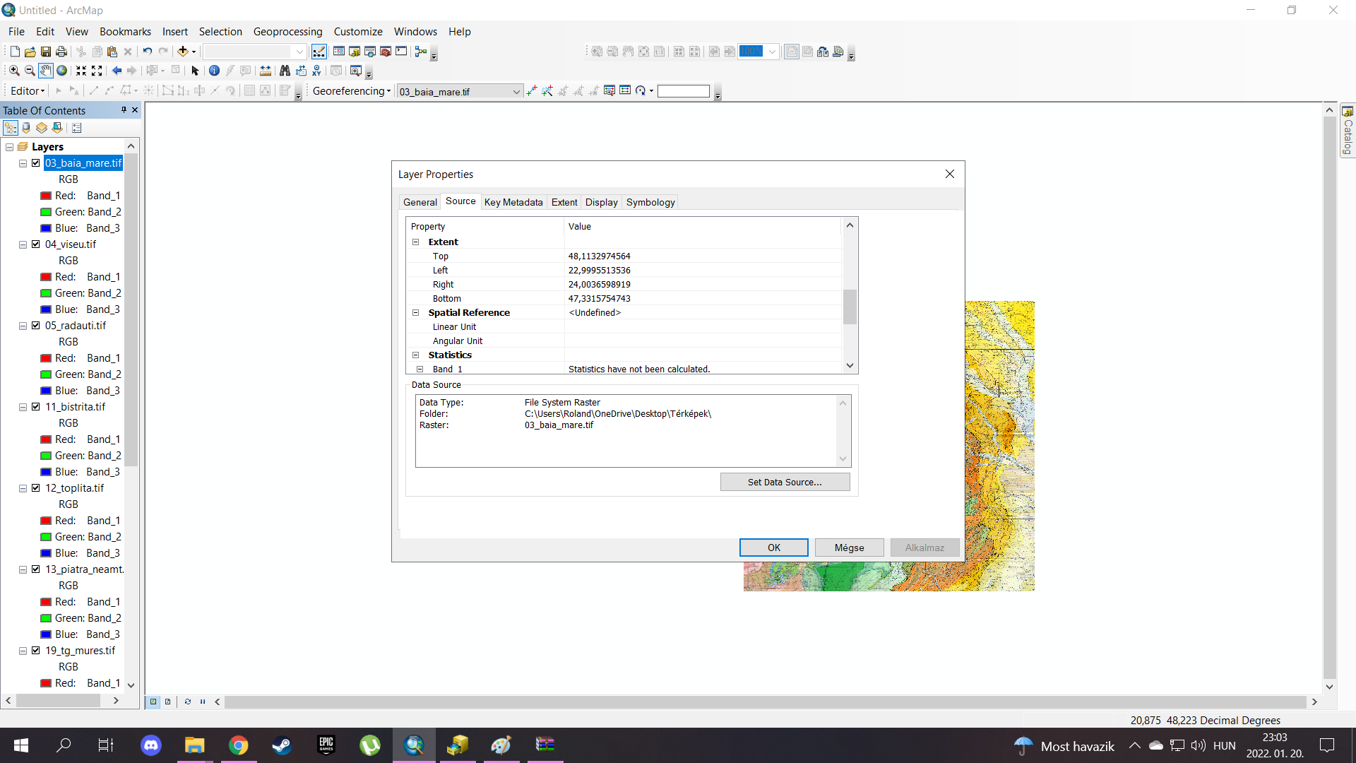
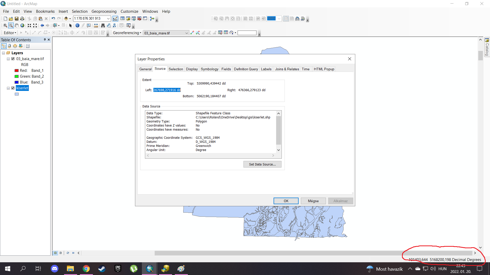
print6.png is in projected coordinates (utm zone)
print7 and print 8 are in decimal degrees (Geographic coordinates, not utm)
So go from there.
... sort of retired...
- Mark as New
- Bookmark
- Subscribe
- Mute
- Subscribe to RSS Feed
- Permalink
If you specified the tif's spatial reference the same as the shapefiles (which work well together), then the tif isn't in the same coordinate system as the shapefiles. You will need to determine what it appears to be in (perhaps it has long/lat coordinates or projected coordinates that differ from the shapefiles).
examine the coordinate space for the tiff map, are they in the range -180 to 180 and -90 to 90? if so then it is a geographic coordinate system . If the numbers are large, then it is in a projected coordinate system and you will have to use an educated guess as to which one it is in.
... sort of retired...
- Mark as New
- Bookmark
- Subscribe
- Mute
- Subscribe to RSS Feed
- Permalink
@DanPatterson was just typing the same thing. Sounds like the TIFF is probably WGS84.
David
..Maps with no limits..
- Mark as New
- Bookmark
- Subscribe
- Mute
- Subscribe to RSS Feed
- Permalink
perhaps a GCS (geographic coordinate system, aka long/lat coordinates) with a WGS84 datum since projected coordinate systems can have that same datum but planar coordinates (aka meters or feet)
... sort of retired...
- Mark as New
- Bookmark
- Subscribe
- Mute
- Subscribe to RSS Feed
- Permalink
If I understand clearly I need to find GCS and not to set up to a projected coordinate system; firstly I tried to import an xy database in wgs84, and worked in both case (in separate arc map windows tiffs and shapes) but after i put in catalog all shapes and tiff’s in wgs84, and import in a same arc map the maps not overlapping.
- Mark as New
- Bookmark
- Subscribe
- Mute
- Subscribe to RSS Feed
- Permalink
You don't define something that it isn't.
You use "Define Projection" when you know what it is and it doesn't have one defined already (or was wrongly defined)
You use "Project" (vectors) or Project Raster (images) to convert to a different coordinate system.
Figure out what you have and decide what coordinate system you want to use. Define for those that don't have a defined or have a wrong coordinate system.
Why not make it easier on all, if you report what coordinate systems you have and what values you have for the one(s) that are undefined.
... sort of retired...
- Mark as New
- Bookmark
- Subscribe
- Mute
- Subscribe to RSS Feed
- Permalink
Could you share the screenshots of the extent (Layer properties > Source tab) of the Raster and the vector layer?
Where (on Earth) should the layers fall?
Think Location
- Mark as New
- Bookmark
- Subscribe
- Mute
- Subscribe to RSS Feed
- Permalink
GCS_WGS_1984 is not the correct coordinate system for the shapefile. It should be a Projected Coordinate System.
Use Define Projection to define the projection of shapefile as WGS_1984_UTM_Zone_34N (Assuming Hungary is your area of interest).
For the Raster files, GCS_WGS_1984 looks just fine.
Think Location