Turn on suggestions
Auto-suggest helps you quickly narrow down your search results by suggesting possible matches as you type.
Cancel
- Home
- :
- All Communities
- :
- Products
- :
- ArcGIS Workflow Manager
- :
- ArcGIS Workflow Manager Questions
- :
- Re: page 25 step 15 e
Options
- Subscribe to RSS Feed
- Mark Topic as New
- Mark Topic as Read
- Float this Topic for Current User
- Bookmark
- Subscribe
- Mute
- Printer Friendly Page
page 25 step 15 e
Subscribe
6430
7
09-08-2013 03:48 AM
by
Anonymous User
Not applicable
09-08-2013
03:48 AM
- Mark as New
- Bookmark
- Subscribe
- Mute
- Subscribe to RSS Feed
- Permalink
Original User: lilgezuz05
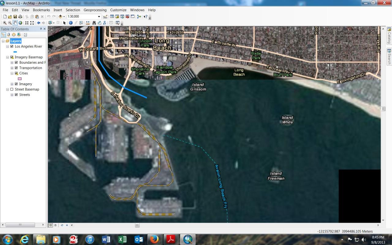
When i zoom in on the harbor I get an area that is blacked out any idea's how to fix this?
here it is at 1:30,000
[ATTACH=CONFIG]27279[/ATTACH]
Here it is at 1:25,000
[ATTACH=CONFIG]27280[/ATTACH]
When i zoom in on the harbor I get an area that is blacked out any idea's how to fix this?
here it is at 1:30,000
[ATTACH=CONFIG]27279[/ATTACH]
Here it is at 1:25,000
[ATTACH=CONFIG]27280[/ATTACH]
7 Replies
09-09-2013
11:18 AM
- Mark as New
- Bookmark
- Subscribe
- Mute
- Subscribe to RSS Feed
- Permalink
Hi,
Sorry for this problem. It has occasionally happened to others, but it's not quite clear what causes it. Here are some suggestions:
First: make sure hardware acceleration is enabled. To do this, from the Customize menu, choose ArcMap Options. Click the Data View tab. If necessary, check the box to enable hardware acceleration for supported layers.
Second: remove the Streets basemap from the map document. I don't think it's needed anymore in the exercise and see if that helps. If not...
Third: remove the Imagery basemap from the map document, then add it again. See if that works. If not...
Fourth: Replace the version of the Imagery basemap you're using with the current version of Imagery or Imagery with Labels from the Add Basemap window. From the screen captures you sent, it looks like you recreated an older version of the Imagery basemap... perhaps by adding a layer package from ArcGIS Online? The current version doesn't have sublayers for Boundaries and Places or Transportation. If you add the current Imagery basemap from the Add Basemap window, this may perform better. (Although your screen won't exactly match the images in the book.)
Let us know if any of that helps. I have also contacted Tech Support to see if they can give some additional information, as I noticed that this same issue was reported to them in 2011. If they have some other ideas, I will post them as soon as I find out.
Tim
by
Anonymous User
Not applicable
09-10-2013
08:15 AM
- Mark as New
- Bookmark
- Subscribe
- Mute
- Subscribe to RSS Feed
- Permalink
Original User: lilgezuz05
"Fourth: Replace the version of the Imagery basemap you're using with the current version of Imagery or Imagery with Labels from the Add Basemap window. From the screen captures you sent, it looks like you recreated an older version of the Imagery basemap... perhaps by adding a layer package from ArcGIS Online? The current version doesn't have sublayers for Boundaries and Places or Transportation. If you add the current Imagery basemap from the Add Basemap window, this may perform better. (Although your screen won't exactly match the images in the book.)"
If I did somehow recreate an older version I have no idea how I did. All I did when I added my base map was click the drop down menu and clicked add base map. Then clicked the imagery base map and that is what I got. Also I tried all of the other ideas, and none of them worked sadly. Also I uninstalled ARC GIS and reinstalled it, then reinstalled the project files from the disc in the book, and still had the same problem.
My computer specs are as follows:
Windows 7 ultimate 64 bit. SP1
Intel i5 3.20 GHZ
8 GB Ram
Graphic card: NVidia GEForce GTX 650
Internet Speed from from my location (South Korea) to LA is:
Download Speed: 21200 kbps (2650 KB/sec transfer rate)
Upload Speed: 4223 kbps (527.9 KB/sec transfer rate)
09-10-2013
12:46 PM
- Mark as New
- Bookmark
- Subscribe
- Mute
- Subscribe to RSS Feed
- Permalink
Hi Gregory,
it doesn't look to me like there should be any problems with your system configuration. There is a utility you can run to confirm that you meet all systems requirements. It's available from this page: http://resources.arcgis.com/en/help/system-requirements/10.2/index.html#. Scroll down to the Hardware requirements section, and in the Video/Graphics adaptor box, you'll see a link to "Check your computer's ability to run ArcGIS." It's fast and easy, although you need a current Java plug-in. One piece of advice I got from tech support was to make sure your graphics driver is current, so I think this test is worthwhile.
You're probably sick of jumping through hoops at this point, but one more idea I had--because I'm still confused about why you see an old version of the Imagery basemap--is to clear your ArcMap cache and see if that helps. From the Customize menu in ArcMap, click ArcMap Options, click the Display Cache tab, and click Clear Cache. Relatively painless (compared to reinstalling the software).
I am waiting for an email response from some other tech support guys, so a better idea may still come along. But try these two suggestions and if it's still no good, send me an email at [email protected] and we'll keep pursuing it.
Again, really sorry for the difficulties and the trouble it's putting you to.
Tim
09-10-2013
02:12 PM
- Mark as New
- Bookmark
- Subscribe
- Mute
- Subscribe to RSS Feed
- Permalink
I also forgot to ask a basic question: what version of ArcGIS for Desktop are you using? 10.0? Another possible cause is that you don't have a current service pack for the software. Instructions for finding out what service pack you have are at this page:
http://training.esri.com/campus/catalog/softwareversion/SoftwareVersionText.cfm
Service pack updates are available at this page:
http://support.esri.com/en/downloads/patches-servicepacks
But maybe you already took care of this when you reinstalled the software.
I found a colleague here who had the same problem a couple of years ago. He said that he dealt with it by turning the Transportation sublayer off, which--at least in his case--avoided the black screen problem. It's not the happiest solution, but it would be an easy thing to try.
Tim
by
Anonymous User
Not applicable
09-11-2013
12:57 AM
- Mark as New
- Bookmark
- Subscribe
- Mute
- Subscribe to RSS Feed
- Permalink
Original User: lilgezuz05
Product Name: ArcGIS Desktop 10
Release Version: 10.0
Product Version: 10.0.0.2414
Installation Folder: C:\Program Files (x86)\ArcGIS\Desktop10.0\
Installed By:
Service Pack Information
ArcGIS Service Pack: 0 (build 0)
ArcGIS Service Pack Installer: N/A
ArcGIS Service Pack Install Date: N/A
ArcGIS Service Pack Install Time: N/A
ArcGIS Service Pack Status: N/A
License Manager Environment Variable Information
ARCGIS_LICENSE_FILE: N/A
LM_LICENSE_FILE: N/A
This is the build I downloaded directly from www.esri.com/90daytrial it looks like it comes with version 10 and no service pack. I see that Version 10.0 has a service pack 5. So I just downloaded SP5 and will give it a shot.
09-11-2013
07:58 AM
- Mark as New
- Bookmark
- Subscribe
- Mute
- Subscribe to RSS Feed
- Permalink
phew.... I got it working. So here is what I did: Complete uninstall again, then reinstall, also installed sp5, then restarted the project, but this time I zoomed into the layer of 1:10,000 before I added the Imagery base map, once I was on that layer then I added the basemap and enabled boundaries and transportation, and it finally worked with a clear picture. Just for kicks I zoomed out to view the whole LA area, then tried to zoom back in again with the imagery basemap layer on, and ended up with the same problem, but I just zoomed back out and disabled imagery and zoomed in with only streets layer on, then turned on imagery and it worked again no problems. I would like to say that this is what fixed it, but I cannot because I did try this before prior to reinstall and it did not work. So what actually made this work seems like a combination of the reinstall, sp5, and turning off the basemap while zooming.
Thanks for all of your help.
Greg.
Thanks for all of your help.
Greg.
by
Anonymous User
Not applicable
09-12-2013
07:54 AM
- Mark as New
- Bookmark
- Subscribe
- Mute
- Subscribe to RSS Feed
- Permalink
Original User: timor
Hi Greg,
Thanks for being so persistent. I'm really glad you got it working--if not in a perfect way, at least in a usable way. I hope it's all clear sailing for you after this, but if not, please let us know.
Tim
Hi Greg,
Thanks for being so persistent. I'm really glad you got it working--if not in a perfect way, at least in a usable way. I hope it's all clear sailing for you after this, but if not, please let us know.
Tim