- Home
- :
- All Communities
- :
- Products
- :
- ArcGIS Web AppBuilder
- :
- ArcGIS Web AppBuilder Questions
- :
- Re: Web App Builder 7.4\2.15: How to get the “coor...
- Subscribe to RSS Feed
- Mark Topic as New
- Mark Topic as Read
- Float this Topic for Current User
- Bookmark
- Subscribe
- Mute
- Printer Friendly Page
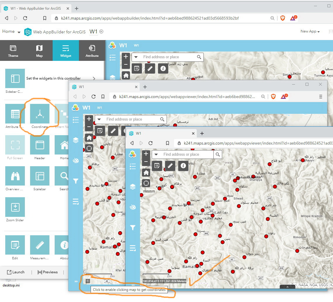
Web App Builder 7.4\2.15: How to get the “coordinates” expanded by default?
- Mark as New
- Bookmark
- Subscribe
- Mute
- Subscribe to RSS Feed
- Permalink
Web App Builder 7.4\2.15: How to get the “coordinates” expanded by default?
I couldn’t figure out how to get the “coordinates” expanded by default.
Jamal Numan
Geomolg Geoportal for Spatial Information
Ramallah, West Bank, Palestine
- Mark as New
- Bookmark
- Subscribe
- Mute
- Subscribe to RSS Feed
- Permalink
Thanks for your reply. So, the hypothesis the issue has something to do with the projection of the map might be right 🙂
Let's see what I do:
- All the data I use are in the Dutch projection (RD_New / 28992)
- In the Netherlands a beautiful set of online basemaps in RD_New is offered by the local reseller, Esri Nederland, even including a recent (and razor sharp) aerial image in that very same projection
- In my ArcGIS Online organization I did create a group Basemaps containing these Dutch basemaps and I did set this to be the default
- So, when I open the Web AppBuilder for ArcGIS to create a new Web Mapping Application the coordinate system is already set to RD_New, and whenever I change the map it will also be in RD_New
...and in this scenario the Coordinate widget works a treat, showing, of course, Dutch coordinates.
Long story short: maybe you should try to set the WKID 28191 as the default in your ArcGIS Online (or Portal) organization.
HTH,
Egge-Jan
- Mark as New
- Bookmark
- Subscribe
- Mute
- Subscribe to RSS Feed
- Permalink
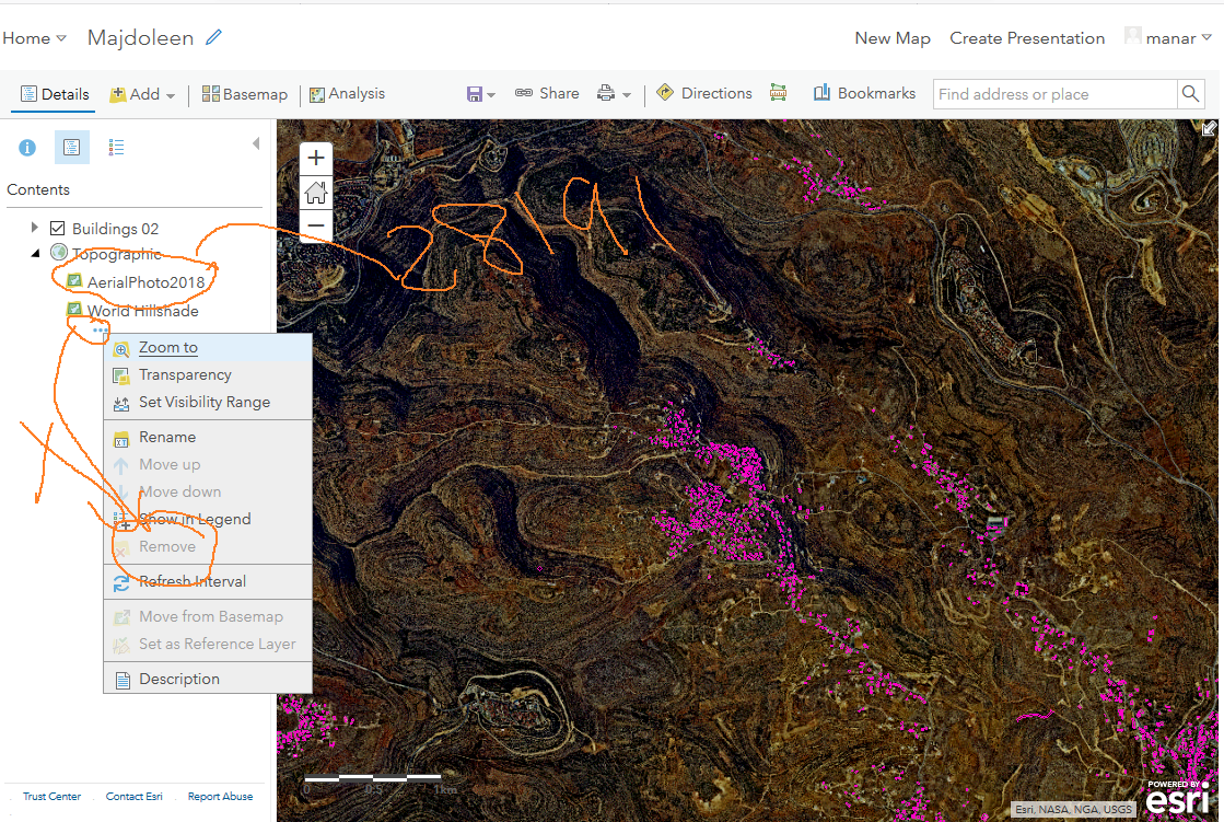
Thank you for your reply, I tried to add a base map with 28191 WKID, and the issue persist to exist. and unfortunately I couldn't delete the "World Hillshade" base map, and the new base map does not appear on the WAB map despite the fact that it is appeared in the map itself, and the “coordinates” does not expanded by default. please see the below:


- Mark as New
- Bookmark
- Subscribe
- Mute
- Subscribe to RSS Feed
- Permalink
Because you did not remove the esri basemap completely your web map is still in WKID 102100 and this is the still the same issue.
- Mark as New
- Bookmark
- Subscribe
- Mute
- Subscribe to RSS Feed
- Permalink
Thank you for your reply, as I mentioned before that I couldn't remove it since the remove button is gray, do you have any idea how to remove it?
- Mark as New
- Bookmark
- Subscribe
- Mute
- Subscribe to RSS Feed
- Permalink
Normally when you add data (from a tiled/cached service) it will ask if you want to add it as a basemap. This is what you want to do. It looks like you some how added it to the topographic esri basemap group.
- Mark as New
- Bookmark
- Subscribe
- Mute
- Subscribe to RSS Feed
- Permalink
Thank you Robert, it works like a charm.
I tried the two options to add the layer as a base map and it works fine.
the first options as shown below to add the tile map from my content

Second option: from WEB

and the coordenate will expanded by default, but why is the default unit is in feet and not meter??

the good thing that I switch it to metric and it works fine:


Thank you
- Mark as New
- Bookmark
- Subscribe
- Mute
- Subscribe to RSS Feed
- Permalink
Thank you guys for the help
Right. Selecting the "use as basemap" option resolves the issue


Jamal Numan
Geomolg Geoportal for Spatial Information
Ramallah, West Bank, Palestine
- Mark as New
- Bookmark
- Subscribe
- Mute
- Subscribe to RSS Feed
- Permalink
Please, vote here:
Web App Builder 9.1\2.2: An option to get the coordinates expanded by default,
Jamal Numan
Geomolg Geoportal for Spatial Information
Ramallah, West Bank, Palestine
- « Previous
-
- 1
- 2
- Next »
- « Previous
-
- 1
- 2
- Next »