- Home
- :
- All Communities
- :
- Products
- :
- ArcGIS Web AppBuilder
- :
- ArcGIS Web AppBuilder Questions
- :
- Re: Selected geometry issue when zoomed in.
- Subscribe to RSS Feed
- Mark Topic as New
- Mark Topic as Read
- Float this Topic for Current User
- Bookmark
- Subscribe
- Mute
- Printer Friendly Page
Selected geometry issue when zoomed in.
- Mark as New
- Bookmark
- Subscribe
- Mute
- Subscribe to RSS Feed
- Permalink
I'm experiencing an issue where when zoomed out and clicking on a parcel the parcel boundary is highlighted and the configured pop-up opens as expected (no problem). When I zoom in to a particular level and click on a parcel, a strange boundary that often roughly follows the parcel boundary (and sometimes not much at all) is highlighted but it is often offset and has many more nodes making it a different shape. I watch the network traffic in fiddler and it's the same layers coming from the same web map regardless of the zoom level. I'm not sure where the click event is located, when I click on the map, to begin debugging (I've put break points in at every place that seemed logical to me).
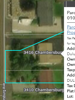
Here is an example of what a particular parcel looks like:
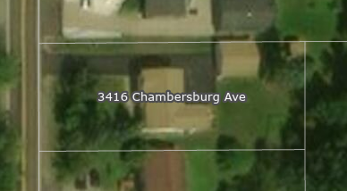
If I zoom out and click on the parcel, the boundary is highlighted in the cyan color as expected but if I zoom in and click on the parcel I get a strange selection polygon that doesn't resemble anything I recognize.
Any suggestions as to what the issue could be or where to continue troubleshooting?
- Mark as New
- Bookmark
- Subscribe
- Mute
- Subscribe to RSS Feed
- Permalink
Andrew,
What version of WAB and what version is the ArcGIS Server where your data is coming from?
- Mark as New
- Bookmark
- Subscribe
- Mute
- Subscribe to RSS Feed
- Permalink
WAB 2.9 and ArcGIS Server 10.7.1
- Mark as New
- Bookmark
- Subscribe
- Mute
- Subscribe to RSS Feed
- Permalink
Andrew,
Seems like I remember one of the older versions of WAB having this issue with generalizing the selection geometry. You should try the latest version of WAB.
- Mark as New
- Bookmark
- Subscribe
- Mute
- Subscribe to RSS Feed
- Permalink
Thanks Robert. That appears to be the issue. Tested in 2.9, an issue. Tested in 2.14, not an issue.