- Home
- :
- All Communities
- :
- Products
- :
- ArcGIS Web AppBuilder
- :
- ArcGIS Web AppBuilder Questions
- :
- Re: Query widget - optional columns how to?
- Subscribe to RSS Feed
- Mark Topic as New
- Mark Topic as Read
- Float this Topic for Current User
- Bookmark
- Subscribe
- Mute
- Printer Friendly Page
- Mark as New
- Bookmark
- Subscribe
- Mute
- Subscribe to RSS Feed
- Permalink
dear Readers,
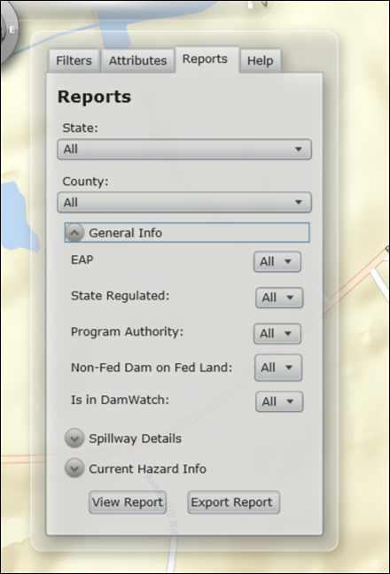
After playing with the results widget, we found that query widget has a bunch of out of the box features. It took me some time to figure out that ALL was the equivalent of AND for all of the columns. In the Silverlight version of our app, (of course it is not out of the box - hand coded stuff) the end users had the ability to choose which filters they could operate on as shown below.
In the picture below, the all would skip the condition for that column through a stored procedure where parameter would @EAPParam = '' and inside the stored procedure the AND condition would be
AND (EAP = @EAPParam or @EAPParam = '') which would ensure that all EAP records are selected.
Now we are trying to implement the same app in WAB 1.3. I was able to open up fiddler and see the GET /ArcGIS/rest/services.... /0/query?f=...... if I choose any then it becomes an OR condition and if I chose ALL
then it is a set of AND conditions. Is there a way to 'intercept' the query and check for <NULL> or '' blank values to remove those from the query stack and send the appropriate values. I understand it cannot be done out of the box and that I have to find a js function in the wab black box.
any links pointers would be appreciated.
regards
ravi.
Solved! Go to Solution.
Accepted Solutions
- Mark as New
- Bookmark
- Subscribe
- Mute
- Subscribe to RSS Feed
- Permalink
Ravi,
I would recommend that you use the eSearch widget as it allows for automatically removing null portions of the SQL if they are not set as required.
- Mark as New
- Bookmark
- Subscribe
- Mute
- Subscribe to RSS Feed
- Permalink
Ravi,
I would recommend that you use the eSearch widget as it allows for automatically removing null portions of the SQL if they are not set as required.
- Mark as New
- Bookmark
- Subscribe
- Mute
- Subscribe to RSS Feed
- Permalink
Robert,
good morning. thanks a lot for your reply and suggestion. I liked at the app and it is pretty nice. Let me see how to implement it in wab 1.3 version of our app/
thanks for your help once again.
regards
ravi.
- Mark as New
- Bookmark
- Subscribe
- Mute
- Subscribe to RSS Feed
- Permalink
Robert,
good afternoon. I went through the document on the internet to set up the widget. I added the columns for the filter optoin and chose the "unique values" option to make it a drop down for end users.
Later on, I am contemplating the use of json to load the dropdown instead of letting widgets go through the whole table of 29000 records. From another project (WAB 1.1, ESRI and my colleague) have a few lines of code to load the dropdown with pre-determined name value pairs. the irritation for me is they started on a blank temple / like about widget. Since the eSearch widget is built, I have to see how to disable the web service search load. Any 1 line suggestions/ pointers would be nice on this/
More important: I am getting Search Failed ! error message. I changed the URL from /FeatureServer/0 to MapServer/0 and back. I am getting the same "Search Failed !". I went through the document to see whether I had missed out any step. I have not missed any.
is there any specific you have to suggest. I put a break point and was very glad to see that the dropdowns that had values were in the search conditions and the others column names did not show up.in the query.
regards
ravi.
- Mark as New
- Bookmark
- Subscribe
- Mute
- Subscribe to RSS Feed
- Permalink
Ravi,
The eSearch has an option for predefined... I am not sure what you are asking. If you choose the predefined option and add a value and label and save then you can open the config_Enhanced Search Widget.json and see what the appropriate format is foe those predefined values (if you are wanting to manually add the predefined values for your 29000 records).
I would have to see your config_Enhanced Search Widget.json to possibly tell you why your search is failing.
- Mark as New
- Bookmark
- Subscribe
- Mute
- Subscribe to RSS Feed
- Permalink
Robert,
thanks for the quick reply. I cannot believe I that there is no way to add a text file as an attachment:
I am copying an pasting the contents: config_Enhanced Search.json
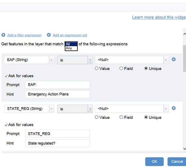
{ "layers": [ { "name": "Dams_Spatial",
"url": "https://gistest1.ftw.nrcs.usda.gov/arcgis/rest/services/hydrography/DamsJS/MapServer/0",
"definitionexpression": "", "spatialsearchlayer": false, "zoomScale": 10000, "forceZoomScale": false, "shareResult": true,
"addToAttrib": true,
"expressions": { "expression": [ {
"alias": "Reports", "textsearchlabel": "Reports", "values": { "value": [
{ "fieldObj": {
"name": "eap", "label": "EAP", "shortType": "string", "type": "esriFieldTypeString" },
"valueObj": {}, "prompt": "EAP is", "textsearchhint": "Emergency Action Plan", "sqltext": "eap = '[value]'",
"operation": "stringOperatorIs", "uniquevalsfromfield": "eap" }, { "fieldObj": { "name": "state_reg", "label": "STATE_REG", "shortType": "string", "type": "esriFieldTypeString" }, "valueObj": { "value": "" }, "prompt": "STATE_REG is", "textsearchhint": "Is Dam state regulated?", "sqltext": "state_reg = '[value]'", "operation": "stringOperatorIs", "uniquevalsfromfield": "state_reg", "operator": "" }, { "fieldObj": { "name": "auth", "label": "AUTH", "shortType": "string", "type": "esriFieldTypeString" }, "valueObj": { "value": "" }, "prompt": "AUTH is", "textsearchhint": "Dam authority classification", "sqltext": "auth = '[value]'", "operation": "stringOperatorIs", "uniquevalsfromfield": "auth", "operator": "" }, { "fieldObj": { "name": "nfdfp", "label": "NFDFP", "shortType": "string", "type": "esriFieldTypeString" }, "valueObj": {}, "prompt": "NFDFP is", "textsearchhint": "Is it a privately owned dam on federal property", "sqltext": "nfdfp = '[value]'", "operation": "stringOperatorIs", "uniquevalsfromfield": "nfdfp", "operator": "" }, { "fieldObj": { "name": "in_damwatch", "label": "in_damwatch", "shortType": "string", "type": "esriFieldTypeString" }, "valueObj": { "value": "" }, "prompt": "in_damwatch is", "textsearchhint": "Is the dam present in dam watch?", "sqltext": "in_damwatch = '[value]'", "operation": "stringOperatorIs", "uniquevalsfromfield": "in_damwatch", "operator": "" }, { "fieldObj": { "name": "spwy_type", "label": "SPWY_TYPE", "shortType": "string", "type": "esriFieldTypeString" }, "valueObj": {}, "prompt": "SPWY_TYPE is", "textsearchhint": "Type of Spillway", "sqltext": "spwy_type = '[value]'", "operation": "stringOperatorIs", "uniquevalsfromfield": "spwy_type", "operator": "" }, { "fieldObj": { "name": "cur_haz", "label": "CUR_HAZ", "shortType": "string", "type": "esriFieldTypeString" }, "valueObj": { "value": "" }, "prompt": "CUR_HAZ is", "textsearchhint": "Current hazard classification:", "sqltext": "cur_haz = '[value]'", "operation": "stringOperatorIs", "uniquevalsfromfield": "cur_haz", "operator": "" }, { "fieldObj": { "name": "om_in_curr", "label": "O_M_IN_CURR", "shortType": "string", "type": "esriFieldTypeString" }, "valueObj": { "value": "" }, "prompt": "O_M_IN_CURR is", "textsearchhint": "Is operation and maintenance current:", "sqltext": "om_in_curr = '[value]'", "operation": "stringOperatorIs", "uniquevalsfromfield": "om_in_curr", "operator": "" }, { "fieldObj": { "name": "rehab", "label": "rehab", "shortType": "string", "type": "esriFieldTypeString" }, "valueObj": { "value": "N" }, "prompt": "rehab is", "textsearchhint": "Was any rehabilitation work done on dam?", "sqltext": "rehab = '[value]'", "operation": "stringOperatorIs", "uniquevalsfromfield": "rehab", "operator": "" }, { "fieldObj": { "name": "dsgn_haz", "label": "DSGN_HAZ", "shortType": "string", "type": "esriFieldTypeString" }, "valueObj": { "value": "" }, "prompt": "DSGN_HAZ is", "textsearchhint": "Design or modified hazard class:", "sqltext": "dsgn_haz = '[value]'", "operation": "stringOperatorIs", "uniquevalsfromfield": "dsgn_haz", "operator": "" } ] } } ] }, "titlefield": "dam_name", "fields": { "all": false, "field": [ { "name": "st_name", "alias": "ST_NAME" }, { "name": "dam_name", "alias": "DAM_NAME", "popuponly": true }, { "name": "other_names", "alias": "OTHER_NAMES" }, { "name": "former_names", "alias": "FORMER_NAMES" }, { "name": "fed_id", "alias": "FED_ID" }, { "name": "nid_id", "alias": "NID_ID" }, { "name": "long_deg", "alias": "LONG_DEG", "isnumber": true }, { "name": "lat_deg", "alias": "LAT_DEG", "isnumber": true }, { "name": "geodetic_loc", "alias": "GEODETIC_LOC" }, { "name": "county", "alias": "COUNTY" }, { "name": "stream", "alias": "STREAM" }, { "name": "nearest_town", "alias": "NEAREST_TOWN" }, { "name": "dist_town", "alias": "DIST_TOWN", "isnumber": true }, { "name": "owner_name", "alias": "OWNER_NAME" }, { "name": "owner_type", "alias": "OWNER_TYPE" }, { "name": "dam_dsgnr", "alias": "DAM_DSGNR" }, { "name": "nfdfp", "alias": "NFDFP" }, { "name": "dam_type", "alias": "DAM_TYPE" }, { "name": "core", "alias": "CORE" }, { "name": "fndn", "alias": "FNDN" }, { "name": "purposes", "alias": "PURPOSES" }, { "name": "yr_comp", "alias": "YR_COMP" }, { "name": "yr_mod", "alias": "YR_MOD" }, { "name": "dam_len", "alias": "DAM_LEN", "isnumber": true }, { "name": "dam_ht", "alias": "DAM_HT", "isnumber": true }, { "name": "str_ht", "alias": "STR_HT", "isnumber": true }, { "name": "hydr_ht", "alias": "HYDR_HT", "isnumber": true }, { "name": "max_disc", "alias": "MAX_DISC", "isnumber": true }, { "name": "max_stor", "alias": "MAX_STOR", "isnumber": true }, { "name": "norm_stor", "alias": "NORM_STOR", "isnumber": true }, { "name": "surf_a", "alias": "SURF_A", "isnumber": true }, { "name": "da", "alias": "DA", "isnumber": true }, { "name": "cur_haz", "alias": "CUR_HAZ" }, { "name": "eap", "alias": "EAP" }, { "name": "last_insp_d", "alias": "LAST_INSP_D" }, { "name": "insp_freq", "alias": "INSP_FREQ", "isnumber": true }, { "name": "state_reg", "alias": "STATE_REG" }, { "name": "state_reg_agency", "alias": "STATE_REG_AGENCY" }, { "name": "spwy_type", "alias": "SPWY_TYPE" }, { "name": "spwy_w", "alias": "SPWY_W", "isnumber": true }, { "name": "out_gates", "alias": "OUT_GATES" }, { "name": "vol_dam", "alias": "VOL_DAM", "isnumber": true }, { "name": "con_asses", "alias": "con_asses" }, { "name": "con_asses_detail", "alias": "con_asses_detail" }, { "name": "assess_date", "alias": "assess_date" }, { "name": "fed_fund", "alias": "FED_FUND" }, { "name": "fed_design", "alias": "FED_DESIGN" }, { "name": "fed_const", "alias": "FED_CONST" }, { "name": "fed_reg", "alias": "FED_REG" }, { "name": "fed_insp", "alias": "FED_INSP" }, { "name": "fed_op", "alias": "FED_OP" }, { "name": "fed_own", "alias": "FED_OWN" }, { "name": "fed_other", "alias": "FED_OTHER" }, { "name": "auth", "alias": "AUTH" }, { "name": "wshed_no", "alias": "WSHED_NO", "isnumber": true }, { "name": "wshed_name", "alias": "WSHED_NAME" }, { "name": "serv_life", "alias": "SERV_LIFE" }, { "name": "om_insp_res", "alias": "O_M_INSP_RES" }, { "name": "om_in_curr", "alias": "O_M_IN_CURR" }, { "name": "om_comp", "alias": "O_M_COMP" }, { "name": "pop_risk", "alias": "POP_RISK", "isnumber": true }, { "name": "pop_acc", "alias": "POP_ACC" }, { "name": "year_pop", "alias": "year_pop", "isnumber": true }, { "name": "dsgn_haz", "alias": "DSGN_HAZ" }, { "name": "haz_class_year", "alias": "HAZ_CLASS_YEAR", "isnumber": true }, { "name": "eap_year", "alias": "EAP_YEAR", "isnumber": true }, { "name": "sed_stor", "alias": "SED_STOR", "isnumber": true }, { "name": "fld_stor", "alias": "FLD_STOR", "isnumber": true }, { "name": "sur_stor", "alias": "SUR_STOR", "isnumber": true }, { "name": "oth_stor", "alias": "OTH_STOR", "isnumber": true }, { "name": "ps_type", "alias": "PS_TYPE" }, { "name": "as1_type", "alias": "AS1_TYPE" }, { "name": "as2_type", "alias": "AS2_TYPE" }, { "name": "as3_type", "alias": "AS3_TYPE" }, { "name": "cond_ht", "alias": "COND_HT", "isnumber": true }, { "name": "cond_w", "alias": "COND_W", "isnumber": true }, { "name": "no_cond", "alias": "NO_COND", "isnumber": true }, { "name": "cool_water", "alias": "COOL_WATER" }, { "name": "rehab", "alias": "rehab" }, { "name": "rehab_year", "alias": "rehab_year", "isnumber": true }, { "name": "state", "alias": "State" }, { "name": "data_source", "alias": "Data_Source" }, { "name": "fips", "alias": "fips" }, { "name": "usertableid", "alias": "usertableid", "isnumber": true }, { "name": "lastupdatedate", "alias": "lastupdatedate", "isdate": true }, { "name": "in_damwatch", "alias": "in_damwatch" } ] }, "links": { "link": [] }, "orderByFields": [], "layersymbolfrom": "server" } ], "initialView": "text", "enablePopupsOnResultClick": true, "disablePopups": false, "disableuvcache": false, "exportsearchurlchecked": false, "limitsearch2mapextentchecked": false, "autozoomtoresults": true, "mouseovergraphics": false, "bufferDefaults": { "addtolegend": false, "bufferUnits": { "bufferUnit": [ { "name": "UNIT_FOOT", "label": "Feet" }, { "name": "UNIT_STATUTE_MILE", "label": "Miles" }, { "name": "UNIT_METER", "label": "Meter" } ] }, "bufferDefaultValue": 5, "bufferWKID": 102003, "simplefillsymbol": { "color": [ 1, 185, 253, 128 ], "outline": { "color": [ 1, 185, 253, 204 ], "width": 1, "type": "esriSLS", "style": "esriSLSSolid" }, "type": "esriSFS", "style": "esriSFSSolid" } }, "spatialrelationships": { "spatialrelationship": [ { "name": "esriSpatialRelContains", "label": "entirely contained in" }, { "name": "esriSpatialRelIntersects", "label": "intersected by" }, { "name": "esriSpatialRelEnvelopeIntersects", "label": "intersected by envelope of" } ] }, "graphicalsearchoptions": { "enablepointselect": true, "enablelineselect": true, "enablepolylineselect": true, "enableextentselect": true, "enablecircleselect": true, "enablepolyselect": true, "showmultigraphicsgraphicaloption": true, "showaddtolerancegraphicaloption": true, "showaddsqltextgraphicaloption": true, "showbuffergraphicaloption": true, "buffercheckedbydefaultgraphicaloption": false, "multipartgraphicsearchchecked": false, "addpointtolerancechecked": false, "keepgraphicalsearchenabled": true }, "symbols": { "simplemarkersymbol": null, "picturemarkersymbol": { "url": "images/i_search.png", "height": "20", "width": "20", "type": "esriPMS", "angle": "0" }, "simplelinesymbol": { "type": "esriSLS", "style": "esriSLSSolid", "color": [ 255, 0, 0, 204 ], "width": 2 }, "simplefillsymbol": { "color": [ 255, 0, 0, 128 ], "outline": { "color": [ 255, 0, 0, 204 ], "width": 2, "type": "esriSLS", "style": "esriSLSSolid" }, "type": "esriSFS", "style": "esriSFSSolid" } }, "resultFormat": { "attTitlesymbol": { "bold": false, "italic": true, "underline": false, "color": [ 0, 0, 0, 1 ] }, "attValuesymbol": { "bold": false, "italic": false, "underline": false, "color": [ 0, 0, 0, 255
] } } }
- Mark as New
- Bookmark
- Subscribe
- Mute
- Subscribe to RSS Feed
- Permalink
Robert,
thanks for the quick reply. I cannot believe I that there is no way to add a text file as an attachment:
I am copying an pasting the contents: config_Enhanced Search.json
{ "layers": [ { "name": "Dams_Spatial",
"url": "https://gistest1.ftw.nrcs.usda.gov/arcgis/rest/services/hydrography/DamsJS/MapServer/0",
"definitionexpression": "", "spatialsearchlayer": false, "zoomScale": 10000, "forceZoomScale": false, "shareResult": true,
"addToAttrib": true,
"expressions": { "expression": [ {
"alias": "Reports", "textsearchlabel": "Reports", "values": { "value": [
{ "fieldObj": {
"name": "eap", "label": "EAP", "shortType": "string", "type": "esriFieldTypeString" },
"valueObj": {}, "prompt": "EAP is", "textsearchhint": "Emergency Action Plan", "sqltext": "eap = '[value]'",
"operation": "stringOperatorIs", "uniquevalsfromfield": "eap" }, { "fieldObj": { "name": "state_reg", "label": "STATE_REG", "shortType": "string", "type": "esriFieldTypeString" }, "valueObj": { "value": "" }, "prompt": "STATE_REG is", "textsearchhint": "Is Dam state regulated?", "sqltext": "state_reg = '[value]'", "operation": "stringOperatorIs", "uniquevalsfromfield": "state_reg", "operator": "" }, { "fieldObj": { "name": "auth", "label": "AUTH", "shortType": "string", "type": "esriFieldTypeString" }, "valueObj": { "value": "" }, "prompt": "AUTH is", "textsearchhint": "Dam authority classification", "sqltext": "auth = '[value]'", "operation": "stringOperatorIs", "uniquevalsfromfield": "auth", "operator": "" }, { "fieldObj": { "name": "nfdfp", "label": "NFDFP", "shortType": "string", "type": "esriFieldTypeString" }, "valueObj": {}, "prompt": "NFDFP is", "textsearchhint": "Is it a privately owned dam on federal property", "sqltext": "nfdfp = '[value]'", "operation": "stringOperatorIs", "uniquevalsfromfield": "nfdfp", "operator": "" }, { "fieldObj": { "name": "in_damwatch", "label": "in_damwatch", "shortType": "string", "type": "esriFieldTypeString" }, "valueObj": { "value": "" }, "prompt": "in_damwatch is", "textsearchhint": "Is the dam present in dam watch?", "sqltext": "in_damwatch = '[value]'", "operation": "stringOperatorIs", "uniquevalsfromfield": "in_damwatch", "operator": "" }, { "fieldObj": { "name": "spwy_type", "label": "SPWY_TYPE", "shortType": "string", "type": "esriFieldTypeString" }, "valueObj": {}, "prompt": "SPWY_TYPE is", "textsearchhint": "Type of Spillway", "sqltext": "spwy_type = '[value]'", "operation": "stringOperatorIs", "uniquevalsfromfield": "spwy_type", "operator": "" }, { "fieldObj": { "name": "cur_haz", "label": "CUR_HAZ", "shortType": "string", "type": "esriFieldTypeString" }, "valueObj": { "value": "" }, "prompt": "CUR_HAZ is", "textsearchhint": "Current hazard classification:", "sqltext": "cur_haz = '[value]'", "operation": "stringOperatorIs", "uniquevalsfromfield": "cur_haz", "operator": "" }, { "fieldObj": { "name": "om_in_curr", "label": "O_M_IN_CURR", "shortType": "string", "type": "esriFieldTypeString" }, "valueObj": { "value": "" }, "prompt": "O_M_IN_CURR is", "textsearchhint": "Is operation and maintenance current:", "sqltext": "om_in_curr = '[value]'", "operation": "stringOperatorIs", "uniquevalsfromfield": "om_in_curr", "operator": "" }, { "fieldObj": { "name": "rehab", "label": "rehab", "shortType": "string", "type": "esriFieldTypeString" }, "valueObj": { "value": "N" }, "prompt": "rehab is", "textsearchhint": "Was any rehabilitation work done on dam?", "sqltext": "rehab = '[value]'", "operation": "stringOperatorIs", "uniquevalsfromfield": "rehab", "operator": "" }, { "fieldObj": { "name": "dsgn_haz", "label": "DSGN_HAZ", "shortType": "string", "type": "esriFieldTypeString" }, "valueObj": { "value": "" }, "prompt": "DSGN_HAZ is", "textsearchhint": "Design or modified hazard class:", "sqltext": "dsgn_haz = '[value]'", "operation": "stringOperatorIs", "uniquevalsfromfield": "dsgn_haz", "operator": "" } ] } } ] }, "titlefield": "dam_name", "fields": { "all": false, "field": [ { "name": "st_name", "alias": "ST_NAME" }, { "name": "dam_name", "alias": "DAM_NAME", "popuponly": true }, { "name": "other_names", "alias": "OTHER_NAMES" }, { "name": "former_names", "alias": "FORMER_NAMES" }, { "name": "fed_id", "alias": "FED_ID" }, { "name": "nid_id", "alias": "NID_ID" }, { "name": "long_deg", "alias": "LONG_DEG", "isnumber": true }, { "name": "lat_deg", "alias": "LAT_DEG", "isnumber": true }, { "name": "geodetic_loc", "alias": "GEODETIC_LOC" }, { "name": "county", "alias": "COUNTY" }, { "name": "stream", "alias": "STREAM" }, { "name": "nearest_town", "alias": "NEAREST_TOWN" }, { "name": "dist_town", "alias": "DIST_TOWN", "isnumber": true }, { "name": "owner_name", "alias": "OWNER_NAME" }, { "name": "owner_type", "alias": "OWNER_TYPE" }, { "name": "dam_dsgnr", "alias": "DAM_DSGNR" }, { "name": "nfdfp", "alias": "NFDFP" }, { "name": "dam_type", "alias": "DAM_TYPE" }, { "name": "core", "alias": "CORE" }, { "name": "fndn", "alias": "FNDN" }, { "name": "purposes", "alias": "PURPOSES" }, { "name": "yr_comp", "alias": "YR_COMP" }, { "name": "yr_mod", "alias": "YR_MOD" }, { "name": "dam_len", "alias": "DAM_LEN", "isnumber": true }, { "name": "dam_ht", "alias": "DAM_HT", "isnumber": true }, { "name": "str_ht", "alias": "STR_HT", "isnumber": true }, { "name": "hydr_ht", "alias": "HYDR_HT", "isnumber": true }, { "name": "max_disc", "alias": "MAX_DISC", "isnumber": true }, { "name": "max_stor", "alias": "MAX_STOR", "isnumber": true }, { "name": "norm_stor", "alias": "NORM_STOR", "isnumber": true }, { "name": "surf_a", "alias": "SURF_A", "isnumber": true }, { "name": "da", "alias": "DA", "isnumber": true }, { "name": "cur_haz", "alias": "CUR_HAZ" }, { "name": "eap", "alias": "EAP" }, { "name": "last_insp_d", "alias": "LAST_INSP_D" }, { "name": "insp_freq", "alias": "INSP_FREQ", "isnumber": true }, { "name": "state_reg", "alias": "STATE_REG" }, { "name": "state_reg_agency", "alias": "STATE_REG_AGENCY" }, { "name": "spwy_type", "alias": "SPWY_TYPE" }, { "name": "spwy_w", "alias": "SPWY_W", "isnumber": true }, { "name": "out_gates", "alias": "OUT_GATES" }, { "name": "vol_dam", "alias": "VOL_DAM", "isnumber": true }, { "name": "con_asses", "alias": "con_asses" }, { "name": "con_asses_detail", "alias": "con_asses_detail" }, { "name": "assess_date", "alias": "assess_date" }, { "name": "fed_fund", "alias": "FED_FUND" }, { "name": "fed_design", "alias": "FED_DESIGN" }, { "name": "fed_const", "alias": "FED_CONST" }, { "name": "fed_reg", "alias": "FED_REG" }, { "name": "fed_insp", "alias": "FED_INSP" }, { "name": "fed_op", "alias": "FED_OP" }, { "name": "fed_own", "alias": "FED_OWN" }, { "name": "fed_other", "alias": "FED_OTHER" }, { "name": "auth", "alias": "AUTH" }, { "name": "wshed_no", "alias": "WSHED_NO", "isnumber": true }, { "name": "wshed_name", "alias": "WSHED_NAME" }, { "name": "serv_life", "alias": "SERV_LIFE" }, { "name": "om_insp_res", "alias": "O_M_INSP_RES" }, { "name": "om_in_curr", "alias": "O_M_IN_CURR" }, { "name": "om_comp", "alias": "O_M_COMP" }, { "name": "pop_risk", "alias": "POP_RISK", "isnumber": true }, { "name": "pop_acc", "alias": "POP_ACC" }, { "name": "year_pop", "alias": "year_pop", "isnumber": true }, { "name": "dsgn_haz", "alias": "DSGN_HAZ" }, { "name": "haz_class_year", "alias": "HAZ_CLASS_YEAR", "isnumber": true }, { "name": "eap_year", "alias": "EAP_YEAR", "isnumber": true }, { "name": "sed_stor", "alias": "SED_STOR", "isnumber": true }, { "name": "fld_stor", "alias": "FLD_STOR", "isnumber": true }, { "name": "sur_stor", "alias": "SUR_STOR", "isnumber": true }, { "name": "oth_stor", "alias": "OTH_STOR", "isnumber": true }, { "name": "ps_type", "alias": "PS_TYPE" }, { "name": "as1_type", "alias": "AS1_TYPE" }, { "name": "as2_type", "alias": "AS2_TYPE" }, { "name": "as3_type", "alias": "AS3_TYPE" }, { "name": "cond_ht", "alias": "COND_HT", "isnumber": true }, { "name": "cond_w", "alias": "COND_W", "isnumber": true }, { "name": "no_cond", "alias": "NO_COND", "isnumber": true }, { "name": "cool_water", "alias": "COOL_WATER" }, { "name": "rehab", "alias": "rehab" }, { "name": "rehab_year", "alias": "rehab_year", "isnumber": true }, { "name": "state", "alias": "State" }, { "name": "data_source", "alias": "Data_Source" }, { "name": "fips", "alias": "fips" }, { "name": "usertableid", "alias": "usertableid", "isnumber": true }, { "name": "lastupdatedate", "alias": "lastupdatedate", "isdate": true }, { "name": "in_damwatch", "alias": "in_damwatch" } ] }, "links": { "link": [] }, "orderByFields": [], "layersymbolfrom": "server" } ], "initialView": "text", "enablePopupsOnResultClick": true, "disablePopups": false, "disableuvcache": false, "exportsearchurlchecked": false, "limitsearch2mapextentchecked": false, "autozoomtoresults": true, "mouseovergraphics": false, "bufferDefaults": { "addtolegend": false, "bufferUnits": { "bufferUnit": [ { "name": "UNIT_FOOT", "label": "Feet" }, { "name": "UNIT_STATUTE_MILE", "label": "Miles" }, { "name": "UNIT_METER", "label": "Meter" } ] }, "bufferDefaultValue": 5, "bufferWKID": 102003, "simplefillsymbol": { "color": [ 1, 185, 253, 128 ], "outline": { "color": [ 1, 185, 253, 204 ], "width": 1, "type": "esriSLS", "style": "esriSLSSolid" }, "type": "esriSFS", "style": "esriSFSSolid" } }, "spatialrelationships": { "spatialrelationship": [ { "name": "esriSpatialRelContains", "label": "entirely contained in" }, { "name": "esriSpatialRelIntersects", "label": "intersected by" }, { "name": "esriSpatialRelEnvelopeIntersects", "label": "intersected by envelope of" } ] }, "graphicalsearchoptions": { "enablepointselect": true, "enablelineselect": true, "enablepolylineselect": true, "enableextentselect": true, "enablecircleselect": true, "enablepolyselect": true, "showmultigraphicsgraphicaloption": true, "showaddtolerancegraphicaloption": true, "showaddsqltextgraphicaloption": true, "showbuffergraphicaloption": true, "buffercheckedbydefaultgraphicaloption": false, "multipartgraphicsearchchecked": false, "addpointtolerancechecked": false, "keepgraphicalsearchenabled": true }, "symbols": { "simplemarkersymbol": null, "picturemarkersymbol": { "url": "images/i_search.png", "height": "20", "width": "20", "type": "esriPMS", "angle": "0" }, "simplelinesymbol": { "type": "esriSLS", "style": "esriSLSSolid", "color": [ 255, 0, 0, 204 ], "width": 2 }, "simplefillsymbol": { "color": [ 255, 0, 0, 128 ], "outline": { "color": [ 255, 0, 0, 204 ], "width": 2, "type": "esriSLS", "style": "esriSLSSolid" }, "type": "esriSFS", "style": "esriSFSSolid" } }, "resultFormat": { "attTitlesymbol": { "bold": false, "italic": true, "underline": false, "color": [ 0, 0, 0, 1 ] }, "attValuesymbol": { "bold": false, "italic": false, "underline": false, "color": [ 0, 0, 0, 255
] } } }
- Mark as New
- Bookmark
- Subscribe
- Mute
- Subscribe to RSS Feed
- Permalink
My apologies that I could not get a clean version to be pasted on the editor. This is failing.
the way my colleague wanted me to do the load of pre-determined filtering values is like this: again this funny UI is making my like difficult: this is not the primary issue now. this can be put to later.
"objMonStatuses": [
{             "name": "Completed"         },
{             "name": "Not Started"         },
{             "name": "RSL Complete"         },
{             "name": "RSL In Progress"         },
{             "name": "RSL QA Ready"         },
{             "name": "State In Progress"         }
]


thanks once again for your patience.
- Mark as New
- Bookmark
- Subscribe
- Mute
- Subscribe to RSS Feed
- Permalink
Ravi,
For this portion you can simply use the Widgets configuration UI to add these predefined values. Take a look at the help