- Home
- :
- All Communities
- :
- Products
- :
- ArcGIS Web AppBuilder
- :
- ArcGIS Web AppBuilder Questions
- :
- Modify Analysis Widget WAB
- Subscribe to RSS Feed
- Mark Topic as New
- Mark Topic as Read
- Float this Topic for Current User
- Bookmark
- Subscribe
- Mute
- Printer Friendly Page
Modify Analysis Widget WAB
- Mark as New
- Bookmark
- Subscribe
- Mute
- Subscribe to RSS Feed
- Permalink
Hello;
I need to modify some of the operations (Aggregate Points, etc) of the WAB Analysis widget with the ArcGIS JS API (3.X).
What I need is to filter the features of the layers involved in the analysis operations, and pass to the geoprocessing service only the filtered features.
The widget uses geoprocessing service, for example:
-https://analysis6.arcgis.com/arcgis/rest/services/tasks/GPServer/AggregatePoints
-https://analysis6.arcgis.com/arcgis/rest/services/tasks/GPServer/XXXX
-Etc
But I don't see in the code (Widget.js) where the geoprocessing service is called, and how the parameters are passed to it.
I see when geoprocessing service is called in the Network tab of the developer tools:

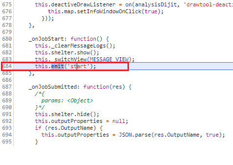
The last line of code that runs before the geoprocessing service is called is this (I believe):

But I do not see how I can modify the code to pass my own parameters. For example, like this:
https://developers.arcgis.com/javascript/3/jssamples/gp_resultmapservice.html (Class: Geoprocessor)
Any suggestions?
Thanks, greetings.