- Home
- :
- All Communities
- :
- Products
- :
- ArcGIS Web AppBuilder
- :
- ArcGIS Web AppBuilder Questions
- :
- Hide the map label on the web app building,
- Subscribe to RSS Feed
- Mark Topic as New
- Mark Topic as Read
- Float this Topic for Current User
- Bookmark
- Subscribe
- Mute
- Printer Friendly Page
- Mark as New
- Bookmark
- Subscribe
- Mute
- Subscribe to RSS Feed
- Permalink
Hide the map label on the web app building,
I am wondering if there is a way to hide the label on a map service at the level of web map builder manager?
Best,
Majdoleen
Solved! Go to Solution.
Accepted Solutions
- Mark as New
- Bookmark
- Subscribe
- Mute
- Subscribe to RSS Feed
- Permalink
You may be able to bring in this service as a feature layer (add the layer ID to the end of the url like this: http://yoursite.com/arcgis/rest/services/yourservice/MapServer/0) into your app's web map. When you do this, you are up against whatever the max records count would return so you may want to limit the scale at which you draw the feature service.
- Mark as New
- Bookmark
- Subscribe
- Mute
- Subscribe to RSS Feed
- Permalink
Majdoleen,
Is the map label a annotation layer in your map service?
- Mark as New
- Bookmark
- Subscribe
- Mute
- Subscribe to RSS Feed
- Permalink
Hi Robert,
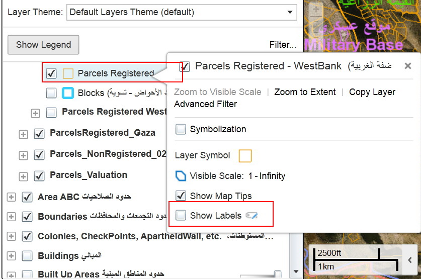
No it is not, but when we published it we enable the symbology and the label is displayed with the feature map.
Best,
Majdoleen
- Mark as New
- Bookmark
- Subscribe
- Mute
- Subscribe to RSS Feed
- Permalink
You may be able to bring in this service as a feature layer (add the layer ID to the end of the url like this: http://yoursite.com/arcgis/rest/services/yourservice/MapServer/0) into your app's web map. When you do this, you are up against whatever the max records count would return so you may want to limit the scale at which you draw the feature service.
- Mark as New
- Bookmark
- Subscribe
- Mute
- Subscribe to RSS Feed
- Permalink
Thank you Ryan, but this seems to be exhausting, since I need to do this for each layer separately!!!!!
which may take time and effort , and tha bad things is when doing the updates on the map, it will not reflect on the app !!!! https://community.esri.com/message/555963?et=watches.email.thread#555963
any idea !!
- Mark as New
- Bookmark
- Subscribe
- Mute
- Subscribe to RSS Feed
- Permalink
Majdoleen,
your best solution would be to convert all your dynamic labeling to annotation Feature Classes in ArcMap and then republish your service so that the annotation will have a item listed in the LayerList widget that can be turned on and off.
- Mark as New
- Bookmark
- Subscribe
- Mute
- Subscribe to RSS Feed
- Permalink
or if you want to maintain the dynamic labeling of the elements, you could make another service that only shows the labels and also add this to your map. You then have the ability to show the elements themselves and labels and either can be toggled on or off.
- Mark as New
- Bookmark
- Subscribe
- Mute
- Subscribe to RSS Feed
- Permalink
Thank you all for the suggestion, but I don't prefer to create a new services for label, I was expected if they will enhance the WAB to have a function that allow the users themselves to turn on/off the label like the on in Geocortex !!
Best,
Majdoleen
- Mark as New
- Bookmark
- Subscribe
- Mute
- Subscribe to RSS Feed
- Permalink
Majdoleen,
OK if you are using ArcGIS Server 10.1 or greater than you can set the LayerDrawingOptions which has a showLabels property on the ArcGISDynamicMapServiceLayer
require([
"esri/layers/LayerDrawingOptions", "esri/renderers/SimpleRenderer", ...
], function(LayerDrawingOptions, SimpleRenderer, ... ) {
var layerDrawingOptions = [];
var layerDrawingOption = new LayerDrawingOptions();
layerDrawingOption.showLabels = false;
layerDrawingOptions[1] = layerDrawingOption;
dynamicData.setLayerDrawingOptions(layerDrawingOptions);
...
});
- Mark as New
- Bookmark
- Subscribe
- Mute
- Subscribe to RSS Feed
- Permalink
Hi Robert,
yes I am using ArcGIS server 10.3.1, but I have no idea what do you mean with this code ? where I can find it ?
any screen shoot may help .
Best,
Majdoleen