- Home
- :
- All Communities
- :
- Products
- :
- ArcGIS Web AppBuilder
- :
- ArcGIS Web AppBuilder Questions
- :
- Challenge for Street Maintenance Web Application
- Subscribe to RSS Feed
- Mark Topic as New
- Mark Topic as Read
- Float this Topic for Current User
- Bookmark
- Subscribe
- Mute
- Printer Friendly Page
Challenge for Street Maintenance Web Application
- Mark as New
- Bookmark
- Subscribe
- Mute
- Subscribe to RSS Feed
- Permalink
I have streets layer, which includes 3 fields: Street name and Municipality codes for Left and Right sides of the street segment. I also have a table that has 2 fields: Municipality code and responsible party for selected municipality code.
Sometimes left and right sides of the street has different municipality code and therefore different responsible party.
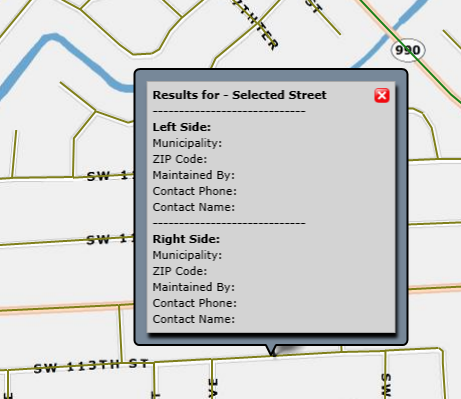
Somehow I need to add a pop-up or something in the Application that will show responsible parties for selevted street...
I was thinking about joining table to the layer, but there are no fields that joint could be based one, besides municipality code (Which could be different for left and right side of the street)
I am looking for something like this:

Any ideas are welcome! THANKS!!!!
- Mark as New
- Bookmark
- Subscribe
- Mute
- Subscribe to RSS Feed
- Permalink
This doesn't address your primary question, but when you do show the popup, you need to also put an arrow at the end of the line segment so users can figure out which is the left side and right side of the street. Something like this, only more cartographic:
=============================>
- Mark as New
- Bookmark
- Subscribe
- Mute
- Subscribe to RSS Feed
- Permalink
You could maybe look at doing a related table and page through the results in the popup. Just a thought.
Also I am no street guy, but it seems to me that left and right sides of a street are subjective to what direction you are facing.
- Mark as New
- Bookmark
- Subscribe
- Mute
- Subscribe to RSS Feed
- Permalink
Thanks, Stan. Streets have predefined direction which define whether house numbers decrease or increase ![]()