- Home
- :
- All Communities
- :
- Products
- :
- ArcGIS Web AppBuilder
- :
- ArcGIS Web AppBuilder Questions
- :
- Re: Accurate measurements with AGOL basemaps
- Subscribe to RSS Feed
- Mark Topic as New
- Mark Topic as Read
- Float this Topic for Current User
- Bookmark
- Subscribe
- Mute
- Printer Friendly Page
- Mark as New
- Bookmark
- Subscribe
- Mute
- Subscribe to RSS Feed
- Permalink
I am looking for a way to get accurate measurements on webmap hosted on AGOL using AGOL basemap (Web Mercator). Is there a way to set the projection of the webmap to UTM without using a custom basemap? Or is there a way to modify the existing measurement and draw widgets to measure in a custom projection (i.e. measure in UTM10 off a webmap in Web Mercator)?
ESRI Canada did direct me to JS samples:
Measurement with projected map | ArcGIS API for JavaScript
Measurement | ArcGIS API for JavaScript
I have no JS dev experience, so before I dive head first into this I'd like to see what other people are doing. Surely I can't be the only on in this boat, Web Mercator seems utterly pointless for measuring when the discrepancies are so high, as illustrated in the sample page below:
Area and Distance Measurements
Measuring distances and areas when your map uses the Mercator projection | ArcGIS Blog
Cheers,
Adam
Solved! Go to Solution.
Accepted Solutions
- Mark as New
- Bookmark
- Subscribe
- Mute
- Subscribe to RSS Feed
- Permalink
I am not sure if this helps, but, in ArcMap I created a square mile polygon shapefile that is located in northern North Dakota using state plane coordinate system. When I bring the shapefile into AGOL and use the measure tools as accurately as I can click with the mouse, I find that the north/south and east/west lengths measure accurately. And measuring the whole polygon reports accurate acreage for a square mile. So, as far as the measure tools in AGOL go, I am convinced that the measurements are reporting accurately without Web Mercator distortion.
See attached shapefile.
- Mark as New
- Bookmark
- Subscribe
- Mute
- Subscribe to RSS Feed
- Permalink
Nothing to contribute, other than I share this concern. We are using NAD 1983 (2011) Alaska State Plane 1, US survey feet, and web mercator gives poor approximations to length and area measurements, particular at latitude N58.
-Bruce
- Mark as New
- Bookmark
- Subscribe
- Mute
- Subscribe to RSS Feed
- Permalink
I am not sure if this helps, but, in ArcMap I created a square mile polygon shapefile that is located in northern North Dakota using state plane coordinate system. When I bring the shapefile into AGOL and use the measure tools as accurately as I can click with the mouse, I find that the north/south and east/west lengths measure accurately. And measuring the whole polygon reports accurate acreage for a square mile. So, as far as the measure tools in AGOL go, I am convinced that the measurements are reporting accurately without Web Mercator distortion.
See attached shapefile.
- Mark as New
- Bookmark
- Subscribe
- Mute
- Subscribe to RSS Feed
- Permalink
Thanks Joe, great idea for testing. I'll create some 1 km sq feature classes in the appropriate UTM zones to check my webmaps. Maybe this is a non-issue, but it would be nice to know what AGOL is using for a projection for the measuring tools. It must be variable depending on your location, and what happens when you webmap spans several UTM zones?
- Mark as New
- Bookmark
- Subscribe
- Mute
- Subscribe to RSS Feed
- Permalink
Thanks again for the suggestion Joe. I created a 1 km sq poly in UTM21, uploaded it to AGOL, and the measurements in AGOL came out accurate. Cheers.
- Mark as New
- Bookmark
- Subscribe
- Mute
- Subscribe to RSS Feed
- Permalink
Adam:
Happy to help and nice to see AGOL measurement accuracy proven in another place on the globe.
Check this out for confirmation by Esri.
- Mark as New
- Bookmark
- Subscribe
- Mute
- Subscribe to RSS Feed
- Permalink
Hi Joe,
I picked up on this issue some time ago, on a different post (from you?):
http://forums.esri.com/Attachments/39021.JPG
I did the same kind of exercise, in ArcMAP 10.1. And found similar disturbing results. Granted, working with measurement tools from the JS api, results are much closer (according to your above post, based on geodesic distances, which are different, of course, than state plane). Anyway, I should check the steps again, but in ArcMAP 10.1:
1) open new mxd
2) add AGOL USA topo map, confirm that the date frame is web mercator, aux sphere
3) set units to make it easy to measure miles, in the data frame's display units
4) zoom in to Juneau (circa W134, N58 - or in the below image, -9306.263, 4998.104 miles)
5) find the corner corresponding to the intersection of 4 sections
6) draw a 1 mile radius circle graphic (looking carefully at the lower left corner, below the TOC, to see when you're about exactly one mile)
and you get the same kind of problem in the attachment you posted above, with the circle drawn about half as large as it should be (cos(60degrees)=0.5).
Here's the 1 mile radius circle I drew, with the radius measured using the measure tool, in miles, with planar units:
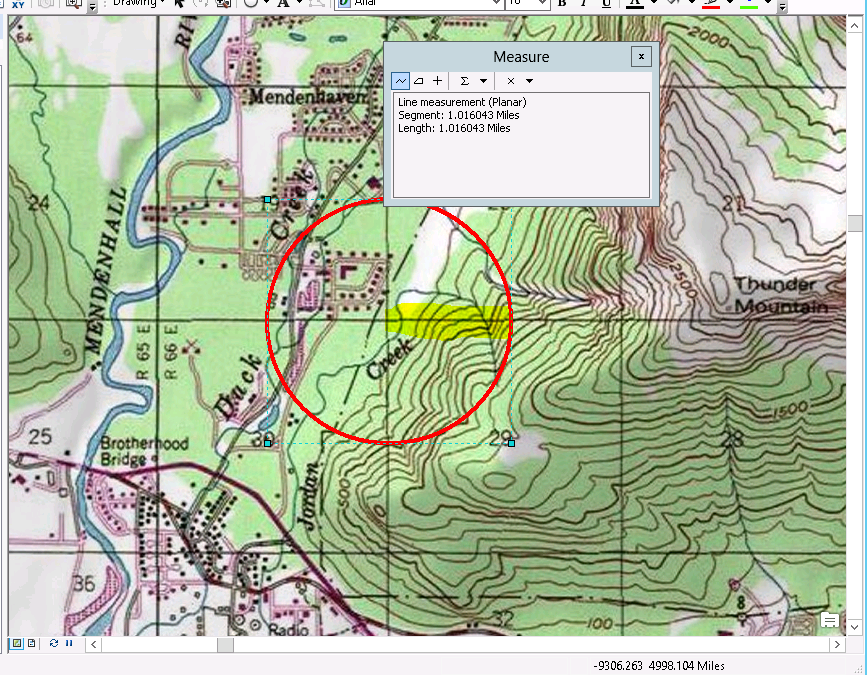
On the other hand, if you use the measure tool, with geodesics, instead of planar, the mile comes out about right.
That shouldn't be a surprise; but what surprised me was, when drawing graphics, in web mercator, I found that I can not trust the measurements of radius, circumference, or areas that are displayed when drawing a circle.
Furthermore, if I change the data frame's projection to state plane or utm, the graphic does not resize (although warning messages about incompatible projections are generated).
So, apparently the JS API is presumably correct, using geodesics, but there are issues with web mercator in ArcMAP 10.1 that one should be aware of. In particular, if your parcel fabric is in State Plane, or UTM, you will get different measurements of areas and lines, than web mercator, with geodesics.
Moral: beware when drawing graphics on top of a data frame in web mercator in ArcMAP, and depending on the on-the-fly dimensions in the lower left, below the TOC.
Cheers,
-Bruce