- Home
- :
- All Communities
- :
- Products
- :
- ArcGIS Viewer for Flex (Retired)
- :
- ArcGIS Viewer for Flex Questions
- :
- Re: Black box this morning for USGS National Map l...
- Subscribe to RSS Feed
- Mark Topic as New
- Mark Topic as Read
- Float this Topic for Current User
- Bookmark
- Subscribe
- Mute
- Printer Friendly Page
Black box this morning for USGS National Map layer failed to load.
- Mark as New
- Bookmark
- Subscribe
- Mute
- Subscribe to RSS Feed
- Permalink
Getting a black box this morning for USGS National Map layer failed to load on all my FlexViewer apps. Any information I missed or is it just down this morning? See attachment please.
Janie
Solved! Go to Solution.
- Mark as New
- Bookmark
- Subscribe
- Mute
- Subscribe to RSS Feed
- Permalink
Janie Goddard Stephen Mitchell - do you have a public facing web app where this can be reproduced? Which browsers (on which platforms) does this happen in?
- Mark as New
- Bookmark
- Subscribe
- Mute
- Subscribe to RSS Feed
- Permalink
My web app is unfortunately not public facing, but I'm including a screenshot of the error I've been getting ...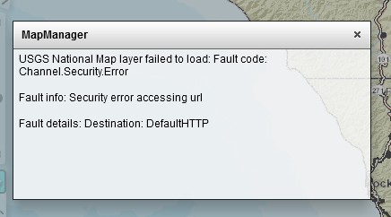
- Mark as New
- Bookmark
- Subscribe
- Mute
- Subscribe to RSS Feed
- Permalink
The Esri example of the basemap widget errors also. https://community.esri.com/external-link.jspa?url=http%3A%2F%2Fresources.arcgis.com%2Fen%2Fhelp%2Fflex-viewer%2Flive%2Findex.html
Http://geodata.cherokee.org/cherokeenation
Firefox and I.e both throw this. These are flexviewers 3.7 on Server 10.2.1.
Janie
Sent from my iPhone
- Mark as New
- Bookmark
- Subscribe
- Mute
- Subscribe to RSS Feed
- Permalink
Hi Bjorn,
Is there any chance of you doing what you did in your response above on Dec 2014:
“For now, we've removed that basemap from the default basemap gallery so there should be no more error messages about that service when starting your flexviewers.”
We would so appreciate your help!
Janie
- Mark as New
- Bookmark
- Subscribe
- Mute
- Subscribe to RSS Feed
- Permalink
Janie Goddard - I think the best option for now is to modify your config.xml files.
There are two possible solutions:
(1) instead of using the default basemap group, point it to an organization that has all-except-USGS basemaps.
(2) instead of asking online/portal for the basemaps, hardcode them in your config.
For option 1
In the map tag, change
addarcgisbasemaps="true"
to
addarcgisbasemaps="false" portalurl="https://YOUR-ORGANIZATION.maps.arcgis.com"
For option 2
1. Change addarcgisbasemaps="true" to addarcgisbasemaps="false"
2. Add the basemaps (this might be slightly idfferent set from what you're used to - adjust as appropriate). Add it inside the map tag, before the operationallayers tag.
 <basemaps>
 <layer label="Topo" type="tiled" visible="true" alpha="1"
 icon="https://www.arcgis.com/sharing/rest/content/items/6e03e8c26aad4b9c92a87c1063ddb0e3/info/thumbnail/topo_map_2.jpg"
 url="https://server.arcgisonline.com/ArcGIS/rest/services/World_Topo_Map/MapServer"/>
 <layer label="Imagery" type="tiled" visible="false" alpha="1"
 icon="https://www.arcgis.com/sharing/rest/content/items/86de95d4e0244cba80f0fa2c9403a7b2/info/thumbnail/tempimagery.jpg"
 url="https://server.arcgisonline.com/ArcGIS/rest/services/World_Imagery/MapServer"/>
 <layer label="Imagery with labels" type="tiled" visible="false" alpha="1"
 icon="assets/images/basemap_imagery_with_labels.png"
 url="https://server.arcgisonline.com/ArcGIS/rest/services/World_Imagery/MapServer"/>
 <layer label="Imagery with labels" type="tiled" visible="false" alpha="1"
 icon="https://www.arcgis.com/sharing/rest/content/items/413fd05bbd7342f5991d5ec96f4f8b18/info/thumbnail/imagery_labels.jpg"
 url="https://services.arcgisonline.com/ArcGIS/rest/services/Reference/World_Boundaries_and_Places/MapServer"/>
 <layer label="Dark Gray Canvas" type="tiled" visible="false" alpha="1"
 icon="https://www.arcgis.com/sharing/rest/content/items/25869b8718c0419db87dad07de5b02d8/info/thumbnail/DGCanvasBase.png"
 url="https://server.arcgisonline.com/ArcGIS/rest/services/Canvas/World_Dark_Gray_Base/MapServer"/>
 <layer label="Dark Gray Canvas" type="tiled" visible="false" alpha="1"
 icon="https://www.arcgis.com/sharing/rest/content/items/25869b8718c0419db87dad07de5b02d8/info/thumbnail/DGCanvasBase.png"
 url="https://services.arcgisonline.com/ArcGIS/rest/services/Canvas/World_Dark_Gray_Reference/MapServer"/>
 <layer label="Light Gray Canvas" type="tiled" visible="false" alpha="1"
 icon="https://www.arcgis.com/sharing/rest/content/items/8b3b470883a744aeb60e5fff0a319ce7/info/thumbnail/light_gray_canvas.jpg"
 url="https://server.arcgisonline.com/ArcGIS/rest/services/Canvas/World_Light_Gray_Base/MapServer"/>
 <layer label="Light Gray Canvas" type="tiled" visible="false" alpha="1"
 icon="https://www.arcgis.com/sharing/rest/content/items/8b3b470883a744aeb60e5fff0a319ce7/info/thumbnail/light_gray_canvas.jpg"
 url="https://services.arcgisonline.com/ArcGIS/rest/services/Canvas/World_Light_Gray_Reference/MapServer"/>
 <layer label="National Geographic" type="tiled" visible="false" alpha="1"
 icon="https://www.arcgis.com/sharing/rest/content/items/509e2d6b034246d692a461724ae2d62c/info/thumbnail/natgeo.jpg"
 url="https://server.arcgisonline.com/ArcGIS/rest/services/NatGeo_World_Map/MapServer"/>
 <layer label="Terrain with labels" type="tiled" visible="false" alpha="1"
 icon="https://www.arcgis.com/sharing/rest/content/items/aab054ab883c4a4094c72e949566ad40/info/thumbnail/terrain_labels.jpg"
 url="https://server.arcgisonline.com/ArcGIS/rest/services/World_Terrain_Base/MapServer"/>
 <layer label="Terrain with labels" type="tiled" visible="false" alpha="1"
 icon="https://www.arcgis.com/sharing/rest/content/items/aab054ab883c4a4094c72e949566ad40/info/thumbnail/terrain_labels.jpg"
 url="https://services.arcgisonline.com/ArcGIS/rest/services/Reference/World_Reference_Overlay/MapServer"/>
 <layer label="Oceans" type="tiled" visible="false" alpha="1"
 icon="https://www.arcgis.com/sharing/rest/content/items/48b8cec7ebf04b5fbdcaf70d09daff21/info/thumbnail/tempoceans.jpg"
 url="https://server.arcgisonline.com/ArcGIS/rest/services/Ocean/World_Ocean_Base/MapServer"/>
 <layer label="Oceans" type="tiled" visible="false" alpha="1"
 icon="https://www.arcgis.com/sharing/rest/content/items/48b8cec7ebf04b5fbdcaf70d09daff21/info/thumbnail/tempoceans.jpg"
 url="https://services.arcgisonline.com/ArcGIS/rest/services/Ocean/World_Ocean_Reference/MapServer"/>
 <layer label="Streets" type="tiled" visible="false"
 icon="assets/images/basemap_streets.jpg"
 url="http://server.arcgisonline.com/ArcGIS/rest/services/World_Street_Map/MapServer"/>
 <layer label="OpenStreetMap" type="osm" visible="false" icon="assets/images/basemap_osm.jpg"/>
 </basemaps>
- Mark as New
- Bookmark
- Subscribe
- Mute
- Subscribe to RSS Feed
- Permalink
Hi Bjorn,
Thanks so much. I like option 2. My problem was I didn't know the URL to the maps that were working. I'll go this direction now.
Thanks,
Janie
- Mark as New
- Bookmark
- Subscribe
- Mute
- Subscribe to RSS Feed
- Permalink
Minor update: all the ArcGIS Online services are better accessed as https, so even the Street service should be https. So in my code block above
http://server.arcgisonline.com/ArcGIS/rest/services/World_Street_Map/MapServer
should be
https://server.arcgisonline.com/ArcGIS/rest/services/World_Street_Map/MapServer
- Mark as New
- Bookmark
- Subscribe
- Mute
- Subscribe to RSS Feed
- Permalink
Thanks Bjorn for keeping us up!
Janie
- Mark as New
- Bookmark
- Subscribe
- Mute
- Subscribe to RSS Feed
- Permalink
Thank you to ESRI for working with USGS to fix this problem. Thank you USGS!
- Mark as New
- Bookmark
- Subscribe
- Mute
- Subscribe to RSS Feed
- Permalink
Thank you ESRI for helping with this! Thanks Janie for getting this on the radar.