- Home
- :
- All Communities
- :
- Products
- :
- ArcGIS Urban
- :
- ArcGIS Urban Questions
- :
- Zoning Boundaries
- Subscribe to RSS Feed
- Mark Topic as New
- Mark Topic as Read
- Float this Topic for Current User
- Bookmark
- Subscribe
- Mute
- Printer Friendly Page
- Mark as New
- Bookmark
- Subscribe
- Mute
- Subscribe to RSS Feed
- Permalink
Hello,
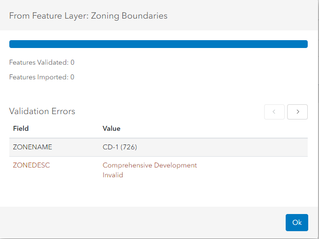
I am having issues loading my Zoning District layer (Zoning Boundaries) into the Urban environment. I keep getting validation errors but there is no information as to what these errors are, and the help document does not contain any useful information for troubleshooting such an issue.
As far as I know and am aware my "Zoning Boundaries" match my Zoning Types I have uploaded.
Any help is appreciated!
Solved! Go to Solution.
Accepted Solutions
- Mark as New
- Bookmark
- Subscribe
- Mute
- Subscribe to RSS Feed
- Permalink
Hi Brian Lee,
Thank you for your question.
Based on your screenshot I suspect that there are Zoning Boundaries which cannot be matched to a Zoning Type.
The values in the Zoning Boundaries' Zoning Type field need to match a value in the Zoning Types' Join ID field. You can define which source field should be used as Zoning Type match field in the Zoning Boundaries import dialog.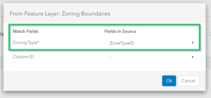
Validation errors on Zoning Boundaries import are usually thrown for Zoning Boundaries pointing to a Zoning Type that does not exist in the Zoning Types table. Please be aware that the matching is also case sensitive - so I'd suggest to not only watch out for blanks but also for upper- and lower-case letters in both, the Zoning Type field of the Zoning Boundaries layer as well as in the Join ID field of the Zoning Types table.
Hope this helps.
- Mark as New
- Bookmark
- Subscribe
- Mute
- Subscribe to RSS Feed
- Permalink
Hi Dominik Allemann,
Thanks for the quick response! My "Zoning Types" was downloaded directly from my "Zoning Boundaries" layer as I was under the assumption the CustomID (Zoning Types) would need to match the "Zoning Type" field and yet it still is invalidated.
Can an issue be caused by one dataset containing 800 records and the other 1000? For instance, if my "Zoning Boundaries" has separated multi-part polygons?
Thanks!
- Mark as New
- Bookmark
- Subscribe
- Mute
- Subscribe to RSS Feed
- Permalink
Hi Brian Lee,
It is common that the amount of Zoning Types (i.e. entries in the Zoning Types table) is smaller than the amount of Zoning Boundaries (the actual geometries), since a certain Zoning Type can usually be assigned to multiple Zoning Boundaries (geometries).
Therefore also multi-part polygons shouldn't cause any issues.
How did you import the Zoning Types into Urban:
a) From Spreadsheet?
b) From Feature Table?
c) From Feature Layer Symbology?
To narrow down the reason for the validation errors you could try to import only a small and overseeable subset of your Zoning Types and Zoning Boundaries - this makes "debugging" a lot easier :-).
Hope this helps.
- Mark as New
- Bookmark
- Subscribe
- Mute
- Subscribe to RSS Feed
- Permalink
Hello!
Okay great, again I assumed so but wasn't sure.
I imported from a spreadsheet and I eventually did discover the problem (an internal one) where there was a discrepancy between the source of the same dataset.
Very happy for your help - thank you so much!
Brian