- Home
- :
- All Communities
- :
- Products
- :
- ArcGIS Survey123
- :
- ArcGIS Survey123 Questions
- :
- Re: Working workflow
- Subscribe to RSS Feed
- Mark Topic as New
- Mark Topic as Read
- Float this Topic for Current User
- Bookmark
- Subscribe
- Mute
- Printer Friendly Page
Working workflow
- Mark as New
- Bookmark
- Subscribe
- Mute
- Subscribe to RSS Feed
- Permalink
Hi, I was hoping to get some input form the community on the best way to accomplish the following workflow.
1) A field tech sets an insect trap in someones yard. They collect location info as well as a description of where the trap is located and a few images of the trap and its location.
2) A week later a field tech (maybe someone different) goes to collect the trap using the description and images to find where the trap has been placed (They are sometimes difficult to see).
3) The field tech re-sets the trap in the same location (hopefully keeping the same description and images available for the next time the trap needs to be collected as well as any additional comments or images)
4) The trap is taken back to the lab and the contents are identified and counted.
What I have now is as follows:
A) At the top level a feature item recording the point location and images.
B) A repeat (related table) that records each trap instance (date set, date collected, etc)
C) A repeat (related table) attached to the trap instance (two levels down from the feature item) which records the number of each species found (one repeat(related record) for each species).
I use the inbox feature for the field techs to see what needs to be collected as well as which collected traps need to be counted. Three forms: One to collect the original features, one for trap instances, one for lab counts.
The problem:
Survey123 doesn't support showing images on surveys accessed through the inbox, so the field tech can't use them as a reference, which makes it difficult for them to find the traps. If they use Collector to find the features they will be able to see the images but they can't use the repeat to enter trap instance information in Collector. I can use URL links to open a form from within collector but then it is not related to the feature.
Is there a way for the tech to see reference images from within Survey123?
Is there a way to start a related record from Collector?
Is there a way to use a QR code (printed on the trap) to pull of the correct feature record as a survey?
Is there another solution I am not thinking of?
Many thanks
- Mark as New
- Bookmark
- Subscribe
- Mute
- Subscribe to RSS Feed
- Permalink
An option that might help is to look into integrate with other field apps. I have done something similar using Collector and Survey123, where my field personnel would use Collector to help orientate/navigate to an asset. They would then verify and select the asset then through a custom html popup the Survey123 form could then be opened directly from Collector.
- Mark as New
- Bookmark
- Subscribe
- Mute
- Subscribe to RSS Feed
- Permalink
Than you for your help Jeremy. Does using URL links between Collector and Survey123 maintain the relationship between the feature layer and the related table?
- Mark as New
- Bookmark
- Subscribe
- Mute
- Subscribe to RSS Feed
- Permalink
Collector is basically a web map that is accessed and can be updated on your mobile device. The feature layer used in the map is the feature layer that is created when you create a new Survey123 form (or when you create a Survey123 form from an existing feature). With Collector I can then preview existing information and then trigger Survey123.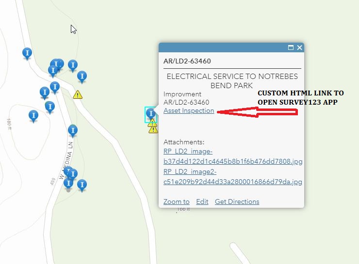
You should also be able to configure something with Survey123 Connect to be use the pull data from a .csv file function where you could incorporate the use of QR/barcode.
- Mark as New
- Bookmark
- Subscribe
- Mute
- Subscribe to RSS Feed
- Permalink
I agree this is the way to go. Seems that everyone wants to use repeats for site visits but it is a bad idea IMHO. Each site visit should be a form. That way you have GPS (were they at the correct spot), editor tracking (when), user cannot change old data, etc.
What I do is build a master FC that is used by 123 and Collector. That way all my forms are viewable in Collector. This seems like a good fit for you. Everything would be connected and they could see all the photos etc from each visit. See my write up in this post https://community.esri.com/thread/221263-mapping-with-survey123-within-a-polygon-or-admin-unit
Hope it helps.
- Mark as New
- Bookmark
- Subscribe
- Mute
- Subscribe to RSS Feed
- Permalink
Hey Doug,
When you say "build a master FC" are you putting all your fields for the forms into a single point, line, or polygon feature class?
- Mark as New
- Bookmark
- Subscribe
- Mute
- Subscribe to RSS Feed
- Permalink
No I have 9 forms that are all there own FC. Then I have a master that I relationship class all of them to.
- Mark as New
- Bookmark
- Subscribe
- Mute
- Subscribe to RSS Feed
- Permalink
Thank you everyone for your suggestions. I have been able to incorporate many of them and have a workflow that seems to work in the field, although with some limitations.
An outline for future readers:
1. I have a feature class that is the authoritative position of the trap. (they can use either Collector or Survey123, although they prefer Survey123 because I have added custom controls)
2. I created an intuitive reference map in Explorer that the field techs can use to find the traps if needed, based on the authoritative FC.
3. There is a URL in the feature that references a Survey123 form and passes some of the trap data over.
4. They then use that form for each collection event which creates a new feature.
a. They can go directly to this form and scan the QR code to enter the trap information without having to use Explore or collector if they already know where the trap i s.
5. I use a processioning tool that checks proximity to the authoritative trap and saves it to a related database.
5. In the lab they use a "Lab" Survey123 form the uses the Inbox to access the features that have been collected and use the essential repeats.
6. I also have a CSV referencing the authoritative traps if the trap is lost or the QR code doesn't work.
One thing that would make it easier in the future would be to be able to access specific repeats using the inbox (an idea for the ESRI team).
Thank you all for your advice, it was invaluable.
- Mark as New
- Bookmark
- Subscribe
- Mute
- Subscribe to RSS Feed
- Permalink
"I use a processioning tool that checks proximity to the authoritative trap and saves it to a related database."
I got one for this that I use. Pretty slick.
First add lat/long to your trap FC. Use a static calc or Arcade for dynamic lat/long (I have this code if you want it). Make sure is WGS84.
Pass the lat/long over to 123.
In the form use this formula to calc the distance from the point sent over from the users current location. Design vs Northing
round(acos(sin(${Northing} * pi() div 180)*sin(${DesignNorthing} * pi() div 180) + cos(${Northing} * pi() div 180)*cos(${DesignNorthing} * pi() div 180)*cos((${DesignEasting} * pi() div 180)-(${Easting} * pi() div 180))) * 6371000,2)
Then I set a constraint on this distance so it yells at them if they are too far away. I do let them override this if they need to - then a question appears as to why they had to override it. This way you have the distance and all that with 0 processing needed.
hope it helps