- Home
- :
- All Communities
- :
- Products
- :
- ArcGIS Survey123
- :
- ArcGIS Survey123 Questions
- :
- Re: Multipart polygons not displaying in browser v...
- Subscribe to RSS Feed
- Mark Topic as New
- Mark Topic as Read
- Float this Topic for Current User
- Bookmark
- Subscribe
- Mute
- Printer Friendly Page
Multipart polygons not displaying in browser version of Survey123 survey
- Mark as New
- Bookmark
- Subscribe
- Mute
- Subscribe to RSS Feed
- Permalink
Hi,
I created a survey and feature service using Connect 3.9.120. It's a geoshape.
I "create" the project boundary shapes for each feature by appending existing project shapes using ArcGIS Pro. I then send the survey url to others. It is set to open in a browser, and I pass the globalID with the url and have it set to edit mode.
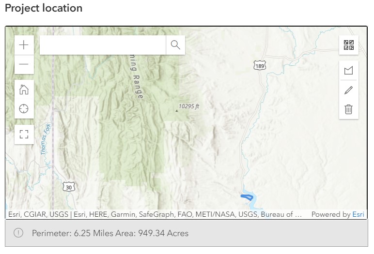
This all works, except when the polygon is a multipart. In those cases, the map in the webform only shows one polygon part. Even if I zoom out in the map, the other polygon parts are not displayed.
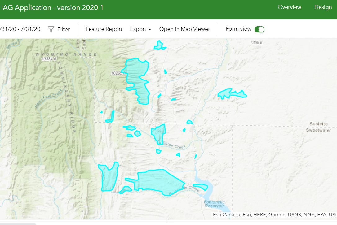
As an example, below is a single feature shown in the Data tab map of survey123.arcgis.com
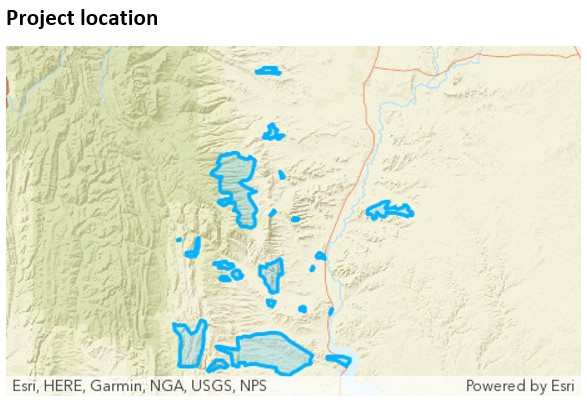
Below is the map showing the multipart polygon in a report generated via survey123.arcgis.com
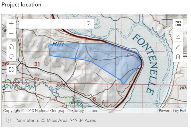
Below is the same feature shown in the webform map
And the same webform map zoomed out, showing that the other parts of the feature are not displayed.
Is this what I should expect? Or does anyone know what I'm doing wrong?
Thanks for any ideas
Solved! Go to Solution.
Accepted Solutions
- Mark as New
- Bookmark
- Subscribe
- Mute
- Subscribe to RSS Feed
- Permalink
I logged a job with ESRI (Australia) about this issue, and they have referred me to the known bug for this issue at: https://my.esri.com/#/support/bugs/BUG-000141310
The bug is marked as "Closed" which I think indicates that they are not planning to fix it. 😞
- Mark as New
- Bookmark
- Subscribe
- Mute
- Subscribe to RSS Feed
- Permalink
Oh, and Maybe I should add that it is a hosted feature layer in AGOL.
- Mark as New
- Bookmark
- Subscribe
- Mute
- Subscribe to RSS Feed
- Permalink
I am afraid I am about to bump into this same problem. @TroyGerhardt1 Did you ever find a solution? @IsmaelChivite Any info on this? Can multipart polygons be used in the Survey123 web app?
- Mark as New
- Bookmark
- Subscribe
- Mute
- Subscribe to RSS Feed
- Permalink
We are experiencing the same issue here when the survey is being run through the app, not the browser. The survey utilises the 'INBOX' feature to be able to run the survey on existing 'geoshape' (polygon) features. However, only one part of the polygon feature is displayed on the map.
Has anybody got any information from ESRI about this issue?
- Mark as New
- Bookmark
- Subscribe
- Mute
- Subscribe to RSS Feed
- Permalink
I did not ever figure out a solution for this issue.
- Mark as New
- Bookmark
- Subscribe
- Mute
- Subscribe to RSS Feed
- Permalink
I logged a job with ESRI (Australia) about this issue, and they have referred me to the known bug for this issue at: https://my.esri.com/#/support/bugs/BUG-000141310
The bug is marked as "Closed" which I think indicates that they are not planning to fix it. 😞
- Mark as New
- Bookmark
- Subscribe
- Mute
- Subscribe to RSS Feed
- Permalink
Hi Troy and others,
Just following up (as noted in case 03096478) that this is currently a known limitation of Survey123.
It has been documented in BUG-000141310 - The ArcGIS Survey123 field app only displays one polygon section of a multipart polygon on the map after refreshing the map from the inbox.
Currently, ArcGIS Survey123 and the XLSForm standard only support single-part geometry objects; multiple parts only display the first part specified.
Kind Regards,
Chris
- Mark as New
- Bookmark
- Subscribe
- Mute
- Subscribe to RSS Feed
- Permalink
Thanks Chris.
For anybody interested, the XLSForm standard is documented at https://xlsform.org/en/ and the 'geoshape' section says:
Record a polygon of multiple GPS coordinates; the last point is the same as the first point.
The single-part only is not explicit there, but I suppose it it implied.
At least we now know that it's not supported in Survey1213 in any case, as confirmed in the bug notes.