- Home
- :
- All Communities
- :
- Products
- :
- ArcGIS Survey123
- :
- ArcGIS Survey123 Questions
- :
- Re: Is it Possible to generate which Census Tract ...
- Subscribe to RSS Feed
- Mark Topic as New
- Mark Topic as Read
- Float this Topic for Current User
- Bookmark
- Subscribe
- Mute
- Printer Friendly Page
Is it Possible to generate which Census Tract an Address is in Using Survey123
- Mark as New
- Bookmark
- Subscribe
- Mute
- Subscribe to RSS Feed
- Permalink
I am currently creating a follow-up tracker for our program and HUD would like us to document the census tract that each of our program participants resides in. Is there a way to have Survey123 generate the census tract for an address, that I can then use pulldata to hold the values for the dashboard display?
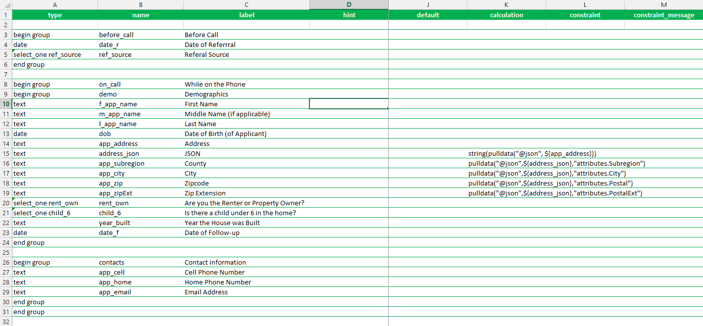
Attached is an image of what I currently have.
Solved! Go to Solution.
Accepted Solutions
- Mark as New
- Bookmark
- Subscribe
- Mute
- Subscribe to RSS Feed
- Permalink
Here is an XLSForm showing how to do it for the web app using pulldata("@layer"). As described in the Early Adopter documentation, Survey123 Connect does NOT support this yet, but if you publish the survey and test it in the web app, it will run fine. It uses the 2020 Census Tract from this layer of the Living Atlas.

- Mark as New
- Bookmark
- Subscribe
- Mute
- Subscribe to RSS Feed
- Permalink
Yes. This is possible, if you have a layer with the census polygons.
If using the Survey123 web application, check the pulldata("@layer") section in this blog: https://community.esri.com/t5/arcgis-survey123-blog/survey123-april-2022-now-available-in-beta/ba-p/...
The pulldata("@layer") syntax allows you to do a point in polygon query against your own layer. It is in Beta at the moment, but we have deployed the code already in production, so it is easy to give it a try. We plan to make this generally available and supported in September this year, although some people are already using it in Beta.
You could also do this with a custom JS function, which has been supported for a while. Or even a web hook to automatically populate the census tract once the data has been submitted.
- Mark as New
- Bookmark
- Subscribe
- Mute
- Subscribe to RSS Feed
- Permalink
Here is an XLSForm showing how to do it for the web app using pulldata("@layer"). As described in the Early Adopter documentation, Survey123 Connect does NOT support this yet, but if you publish the survey and test it in the web app, it will run fine. It uses the 2020 Census Tract from this layer of the Living Atlas.
- Mark as New
- Bookmark
- Subscribe
- Mute
- Subscribe to RSS Feed
- Permalink
Thank you for the help! I am running into an error when I try to update my form with the suggested calculation. I am using the below calculation
pulldata("@layer","getRecord","https://bethlehem-pa.maps.arcgis.com/apps/mapviewer/index.html?webmap=8f22464a082b44b88939adf8b2ed6c..., USA Census Tract)
I am receiving the attached error


I cannot figure out how to make this work. Any assistance would be very greatly appreciated!
Thanks,
Josh
- Mark as New
- Bookmark
- Subscribe
- Mute
- Subscribe to RSS Feed
- Permalink
@IsmaelChivite Worked like a charm, thank you!