- Home
- :
- All Communities
- :
- Products
- :
- ArcGIS Survey123
- :
- ArcGIS Survey123 Questions
- :
- Re: How to specify default geopoint base map in Su...
- Subscribe to RSS Feed
- Mark Topic as New
- Mark Topic as Read
- Float this Topic for Current User
- Bookmark
- Subscribe
- Mute
- Printer Friendly Page
How to specify default geopoint base map in Survey123 Connect?
- Mark as New
- Bookmark
- Subscribe
- Mute
- Subscribe to RSS Feed
- Permalink
Using Survey123 Connect.
Added a geopoint question.
In main Survey123 Connect interface selected map options and then specified default coordinates and map background (Streets Map).
When survey gets published and opened in a browser, the base map is the TOPO map.
Trying to figure how to default to the Streets Map.
Any insights would be appreciated.
- Mark as New
- Bookmark
- Subscribe
- Mute
- Subscribe to RSS Feed
- Permalink
Hi Nadine,
There is a similar enhancement request submitted regarding this issue and the issue is on the webmap viewer, but not the survey123 side.
ENH-000129863 Allow users to edit the names of labels for the ArcGIS Online Legend
The "SurveyPoint" will not be updated on the webmap viewer, even you edited the item page.
I encourage you to contact Esri Support. Our Support team will assign an official enhancement number for your records. Similar requests from other customers can then be attached to the same enhancement request, which helps us assess demand for the enhancement and prioritize it accordingly.
Thanks,
- Mark as New
- Bookmark
- Subscribe
- Mute
- Subscribe to RSS Feed
- Permalink
Thanks Shwu-jing, I'll do that.
- Mark as New
- Bookmark
- Subscribe
- Mute
- Subscribe to RSS Feed
- Permalink
Hi Shwu-jing Jeng,
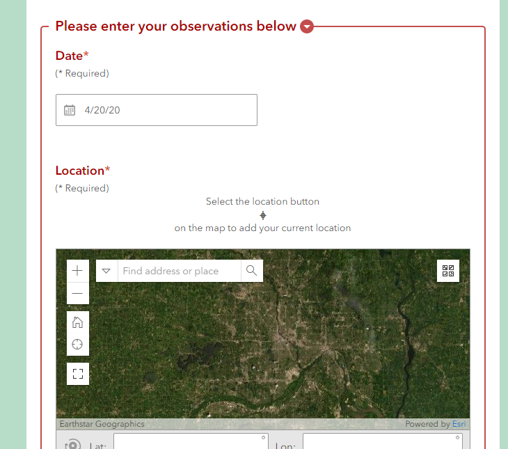
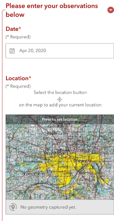
We're seeing this basemap issue on mobile devices.
The basemap has been configured through S123 connect and appears as it should on a desktop device but when we open the form on a mobile device (via URL in browser) the basemap reverts to the USGS basemap regardless of the S123 connect's configuration-
| Desktop Browser | Mobile Browser |
|---|---|
 |  |
- Mark as New
- Bookmark
- Subscribe
- Mute
- Subscribe to RSS Feed
- Permalink
Hi Amanda,
Could you provide further informtaion for your issue as I am not seeing that with my testing here?
1. What version of Survey123 Connect are you using?
2. What basemap did you set as default basemap in Connect>Settings>Map tab?
3. Is the survey published to ArcGIS online or enterprise Portal?
- Mark as New
- Bookmark
- Subscribe
- Mute
- Subscribe to RSS Feed
- Permalink
Thanks for the quick reply!
1. We are using S123 Connect 3.7.62
2. World Topography Basemap
3. Survey is published to ArcGIS Online
- Mark as New
- Bookmark
- Subscribe
- Mute
- Subscribe to RSS Feed
- Permalink
Hi Amanda,
I used connect 3.7.62 and published the map using World Topography, and ,make sure my web version is set to use "Always use the latest version(3.9)." Both the desktop browser preview and mobile device browser(ios safari) is using World Topography correctly.
Are you using iPhone or android? Did you set the web version correctly?
- Mark as New
- Bookmark
- Subscribe
- Mute
- Subscribe to RSS Feed
- Permalink
I set the web survey to use the latest version (3.9), set my preferred basemap to streets and republished my survey from Connect. Still seeing the topo map in the Geopoints widget on the web form.
- Mark as New
- Bookmark
- Subscribe
- Mute
- Subscribe to RSS Feed
- Permalink
Hi Levi,
Could you provide the information of the following questions>
1. The version of Connect you are using to republish the survey
2. How did you create the survey initially? From Connect or web designer?
3. What basemap did you see in field app? Does it honor the street map?
- Mark as New
- Bookmark
- Subscribe
- Mute
- Subscribe to RSS Feed
- Permalink
1. 3.7.62 (tried to update to 3.9 but couldn't)
2. Web Designer
3. Haven't used a field survey, this is strictly web based.
- Mark as New
- Bookmark
- Subscribe
- Mute
- Subscribe to RSS Feed
- Permalink
Hello Levi,
Please forgive if you've already tried this step, but have you tried opening Survey123 Connect then going immediately to> Settings >> Map and specifying
your basemap of choice, then select Publish (overwriting existing service)? I've noticed that if I navigated away from the Map settings before I re-published
my survey, the base map setting would revert back to another basemap style. I was using this in Connect version 3.8 (I believe) but i've since upgraded to
Connect 3.9.120 (still follow the same workflow though...)
hope that helps,
brian
