- Home
- :
- All Communities
- :
- Products
- :
- ArcGIS Survey123
- :
- ArcGIS Survey123 Questions
- :
- Re: Geoshape position and size changing Windows x6...
- Subscribe to RSS Feed
- Mark Topic as New
- Mark Topic as Read
- Float this Topic for Current User
- Bookmark
- Subscribe
- Mute
- Printer Friendly Page
Geoshape position and size changing Windows x64 install
- Mark as New
- Bookmark
- Subscribe
- Mute
- Subscribe to RSS Feed
- Permalink
Our users are experiencing issues with the geoshape tool in Survey123. We have multiple surveys (all built in Connect) that use geoshape questions. The method is set to vertex.
When users draw a polygon on the map interface, they experience the following issues when using the windows desktop field app (tested in versions 3.12.274 and 3.12.277) (but the same issues are also seen when testing in Connect 3.12.232):
- If moving the map, the polygon moves out of sync with the basemap (rather than being fixed to the basemap it 'floats')
- If saving their polygon drawing (by clicking the tick button), the polygon shown in the form is in the wrong place (e.g., moving southwest of the correct position).
After submission, when the polygons are shown either in an ArcGIS Online webmap, or in ArcGIS Pro, polygons can appear in the wrong locations (as described above), and may appear bigger or smaller than the area traced against the basemap. Despite this, the area calculations appear to be correct based on testing so far (i.e., an area calculation in the form matches the area of the submitted polygon shown in ArcGIS Pro).
These issues appear to occur regardless of basemap. Is this a known bug?
Examples below:
Fig 1. Original polygon drawing

Fig 2. Polygon has 'drifted'

Fig. 3. Polygon has drifted (shown in form view)

Software details:
Tested on a laptop running Windows 10 with version 3.12.274 of the x64 Survey123 Field App, and again with version 3.12.277 of the x64 install. Another colleague has also tested with 3.12.277 and has the same issues.
Also tested on a Samsung A71 running Android 11 and version 3.12.277 of the Survey123 Field App. - doesn't appear to have the same issues. Possibly limited to the x64 version of the app?
- Mark as New
- Bookmark
- Subscribe
- Mute
- Subscribe to RSS Feed
- Permalink
Hi @DataOfficer ,
This is most likely an issue with the Windows Display Scaling setting - can you provide what value it is set at? In particular, if the value is not evenly divisible by 100% (i.e., 125%, 150%), the shifting occurs due to a bug with the underlying programming environment (Qt) used by Survey123. This has been resolved in the version of Qt used by the current beta version - could you get the beta from the Early Adopter Community and test?
- Mark as New
- Bookmark
- Subscribe
- Mute
- Subscribe to RSS Feed
- Permalink
Hi @JamesTedrick, is there any update on a resolution to this? We are having to manually correct a large number of geoshapes being submitted through our forms.
Many thanks,
Rob
- Mark as New
- Bookmark
- Subscribe
- Mute
- Subscribe to RSS Feed
- Permalink
Hi @JamesTedrick,
Thank you for the quick response and explanation. Scaling is set to 125% and 175% respectively on the two computers being used for testing.
I have just tested with the beta install (3.13.128) and the 'floating' issues appear to be similar or worse if you move the map window after the polygon has been drawn (first image below). However, when accepting the polygon (via the tick button) and then going back in to it, the polygon does appear to be in the correct place it was originally drawn. Viewing the polygon in an ArcGIS Online webmap still shows issues, in that the drawing that was made in Survey123 appears larger (i.e. outside of the traced boundaries). See the second image below.

I had another member of staff also test on their device (scaling at 175%) but the limited testing they have carried out doesn't show any differences between the submitted polygon and the one appearing in AGOL.
- Mark as New
- Bookmark
- Subscribe
- Mute
- Subscribe to RSS Feed
- Permalink
@JamesTedrick is there any update on a solution for this issue? We are still having to manually correct polygons in ArcGIS Pro/ArcGIS Online after submission with Survey123 which is proving time consuming. Is it best to raise a support case?
Many thanks,
Rob
- Mark as New
- Bookmark
- Subscribe
- Mute
- Subscribe to RSS Feed
- Permalink
@JamesTedrick we are still experiencing this issue (v 3.12.277). Is this resolved in the latest release?
- Mark as New
- Bookmark
- Subscribe
- Mute
- Subscribe to RSS Feed
- Permalink
@JamesTedrick are there any updates on when this issue will be resolved?
- Mark as New
- Bookmark
- Subscribe
- Mute
- Subscribe to RSS Feed
- Permalink
Hi @DataOfficer,
We believe we have now fixed this issue in our 3.15.156 (August update RC) build that is now available on the Early Adopter site. Would you mind please testing this build with your workflows? You should not experience the original issue, even if your display scale is >100%. Please let me know if problems persist.
Many thanks,
Brett
Please let me know.
- Mark as New
- Bookmark
- Subscribe
- Mute
- Subscribe to RSS Feed
- Permalink
Hi @BrettStokes. Thank you for the update. I've just tested it in 3.15.156 and it appears to be working properly.
Kind regards,
Rob
- Mark as New
- Bookmark
- Subscribe
- Mute
- Subscribe to RSS Feed
- Permalink
Hi Brett
I seem to be having that same problem on the latest version of Survey123.
Is there anything that you could suggest that I do?
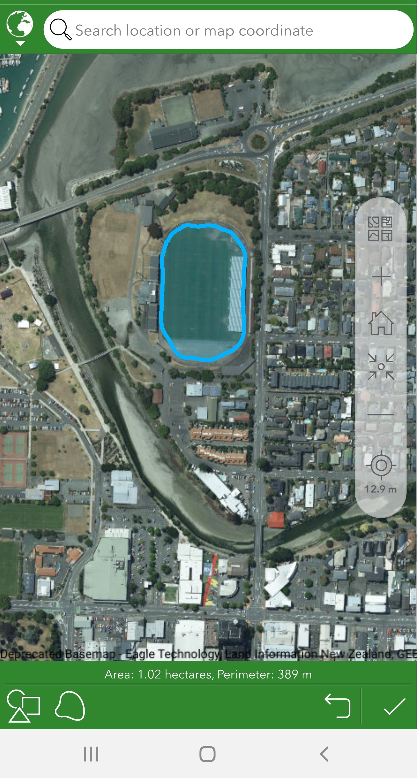
Some screenshots attached showing the original selection, then the geoshape movement when the map has been moved around and also showing a slight transformation after submission.
I would expect the geoshape that has been drawn around the sports field to remain around the sports field no matter the map movement, it should be locked in that position.
Thanks