- Home
- :
- All Communities
- :
- Products
- :
- ArcGIS Survey123
- :
- ArcGIS Survey123 Questions
- :
- Re: Create GeoPoint From Lat & Long Numeric Field ...
- Subscribe to RSS Feed
- Mark Topic as New
- Mark Topic as Read
- Float this Topic for Current User
- Bookmark
- Subscribe
- Mute
- Printer Friendly Page
Create GeoPoint From Lat & Long Numeric Field Collected In a Survey
- Mark as New
- Bookmark
- Subscribe
- Mute
- Subscribe to RSS Feed
- Permalink
Hello All.
I have created a survey using Survey123 Collect. I have given my team the ability to enter a latitude and longitude numeric value via the form.

and I'd like the points to be visible on my AGOL web map.
I am NOT using the map interface approach (which works for 99.9% of my projects) and I won't go into the details as to why not 🙂. The map interface approach would look like this

I really just want to know if or how to get a point on a map using the manual entry Lat/Long fields vs doing it the more typical way via the map based interface. Could this be based on a calculated field in my excel spreadsheet using Connect?
Thanks so much in advance.
GR
Solved! Go to Solution.
Accepted Solutions
- Mark as New
- Bookmark
- Subscribe
- Mute
- Subscribe to RSS Feed
- Permalink
Attaching an XLSForm as an example. Hope it works for you.
- Mark as New
- Bookmark
- Subscribe
- Mute
- Subscribe to RSS Feed
- Permalink
Ismael,
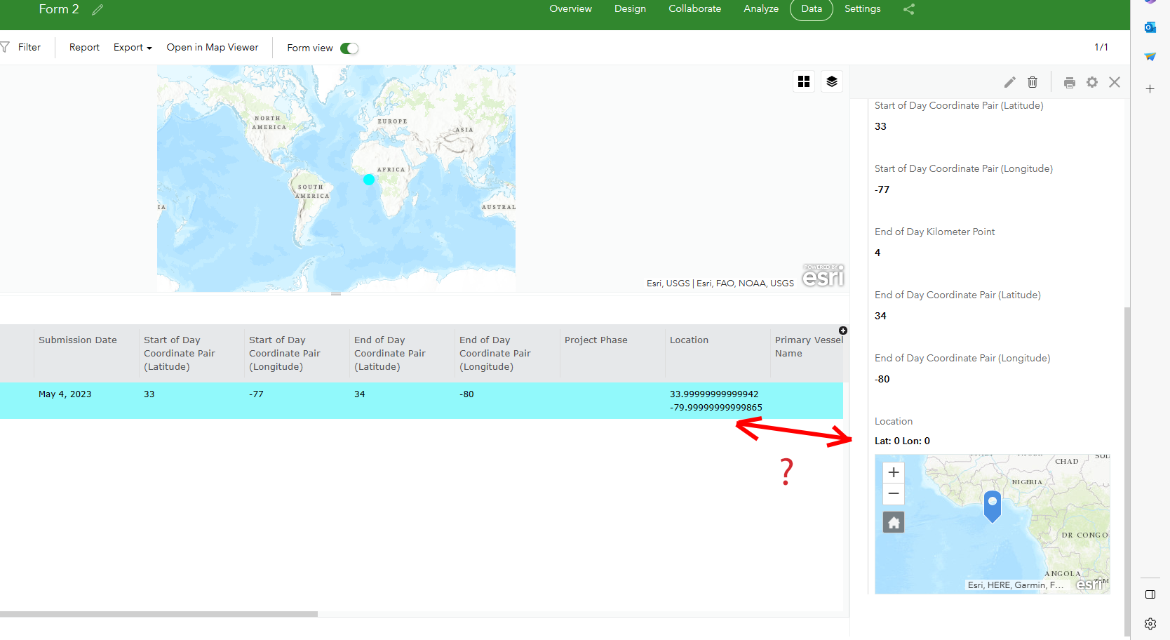
Thank you so much but still a small challenge. I added the geopoint type and referencing my names for lat and long as you instructed. When I ran the survey it popped up a map at the correct location!!!!

However when I opened my webmap the point plotted in the spot "for lost points 🙂".

The next time I submitted, I click on the map pin this time which opened up this window

and I clicked on the checkmark in the lower right corner. That added another point off Africa as well.
It all looked like it would work perfectly but it didn't seem too. Any other guidance would be very helpful.
Thank you for the amazing support either way.
GR
- Mark as New
- Bookmark
- Subscribe
- Mute
- Subscribe to RSS Feed
- Permalink
Can you share your XLSForm? You can include it as an attachment in this thread.
- Mark as New
- Bookmark
- Subscribe
- Mute
- Subscribe to RSS Feed
- Permalink
Ismael
I really can't as it's part of a larger project. That said, other than the geopoint getting plotted in the incorrect place the survey works great. So I simply removed all the other parts of the survey (deleted all the rows out of the .XLSX file except those needed for the coordinates and geopoint), created a new form, ran it and the geopoint plotted perfectly.
The difference between the full survey and the coordinate only survey is:
1. The full survey as many groups.
2. The geopoint calculation is in the middle of the full survey (which doesn't plot correctly).
3. As a subset survey where the geopoint calculation is at the end in its own group it works. The subset survey has the coords assigned, the map pops up and I hit submit.
- Mark as New
- Bookmark
- Subscribe
- Mute
- Subscribe to RSS Feed
- Permalink
@GregReinecke I am not sure what is not working for you. I took your XLSForm, published it, and tested it. As far as I can tell, it is working good. See animation below.

- Mark as New
- Bookmark
- Subscribe
- Mute
- Subscribe to RSS Feed
- Permalink
Thanks again for sticking with this. In the end, I pulled all the content from my excel file (old version for sure) and pasted it into your excel file (new version) and it all worked well. Perhaps during that process I fixed an error on my side. Either way your help is so very much appreciated!!!!!
- Mark as New
- Bookmark
- Subscribe
- Mute
- Subscribe to RSS Feed
- Permalink
if anyone is looking for a single field lat/long input, I've shared an example here.