Flattened Forms
- Subscribe to RSS Feed
- Mark as New
- Mark as Read
- Bookmark
- Subscribe
- Printer Friendly Page
Flattened Forms
Using Survey123 for ArcGIS to eliminate paper data sheets and collect roadkill information
By: Joseph Kinyon, GIS Manager, Sonoma Land Trust
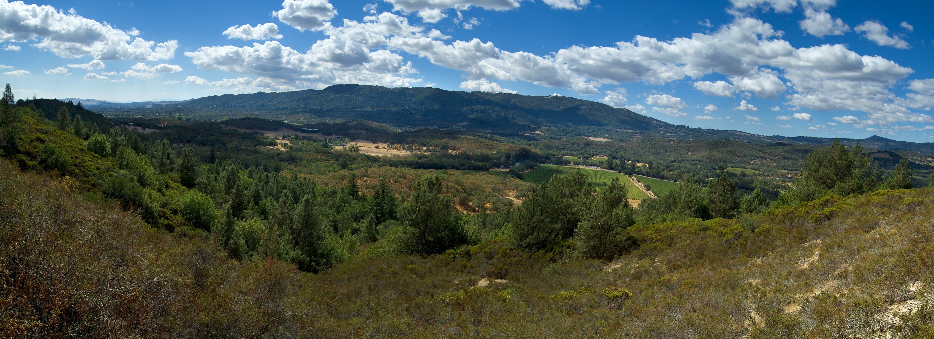
View from Glen Oaks across Sonoma Valley to Sonoma Mountain showing region of wildlife corridor.
Stephen Joseph, Sonoma Land Trust.
Animals move across the landscape. Where and when they do are two of the most ancient questions humans have ever asked. And, we continue to ask. Being observant of animal migrations and their activity reinforced and drove our conceptualization of time and natural cycles for eons.
Understanding the affinity of animals to habitats over time as well as how they move across them involves multiple factors. This type of calculation varies for different types of animals. The connectivity of habitat changes with scale. The size of the animal, range of the population, mobility of animal, and structure of the habitat are all different and interrelated dimensions. It also changes with time. Time can include daily foraging needs, seasonal food availability, animal lifespan, or annual congregations for breeding. For example, a fox’s diet may include birds which eat berries. The birds flock to feed on the berries. A fox may move with its prey because the berries ripen at different rates based on the sun’s angle to the slope in that region. The interplay of the scale of habitat and time drives this one aspect of this animal’s life. That same area can also contain newts that travel hundreds of feet in their lifetime to a seasonal stream to breed; or the area may temporarily contain a mountain lion that ranges tens of miles to hunt deer and raise cubs. Different animals use the same areas differently.
A significant factor dictating how animals move between wildlife habitats is human activity. Wildlife areas sometimes get surrounded or fractured by human development, turning them into a disconnected mosaic of island-like habitats. An animal’s ability to migrate with seasons, move to survive, thrive, find a mate, and (or) for offspring to disperse could end if their habitat connectivity is fractured
We’ve seen that when people own land and subdivide it, they tend to fence the perimeter to keep wild animals, livestock, pets or people in or out. Places with smaller parcels have many more fences subdividing them. Fences are dangerous, difficult, or impossible for many animals to move over, under or through. Roads are dangerous to cross. Animals haven’t evolved to deal with the past 100 years of cars and trucks now racing by at 50 miles an hour. Therefore, places with fewer fences and roads would be the easier regions for animals to move through.
Understanding wildlife habitats and corridors in Sonoma Valley, CA
SC Wildlands, the Bay Area Open Space Council and the Conservation Lands Network led efforts to identify the vital corridors (also known a linkages) connecting large and protected wildlife habitats in the San Francisco Bay area. The Conservation Lands Network Critical Linkages map and data is available publicly.
The linkages data includes analysis of parcel boundaries and road networks that describe a path of least resistance that animals like terrestrial vertebrates (e.g., foxes, lions, and newts) could use when traveling between regions of contiguous habitat (Large Landscape Blocks). Much of this work has its foundation in GIS technology, which allows mapping of an animal’s affinity to a habitat and distill from map data the cost of travel through the habitats those animals use. GIS technology is critical to model and understand wildlife corridors of connectivity between the suitable habitats that animals need.
Local studies around critical wildlife corridors in the Glen Ellen region of Sonoma Valley are being conducted and promoted by the Sonoma Land Trust.
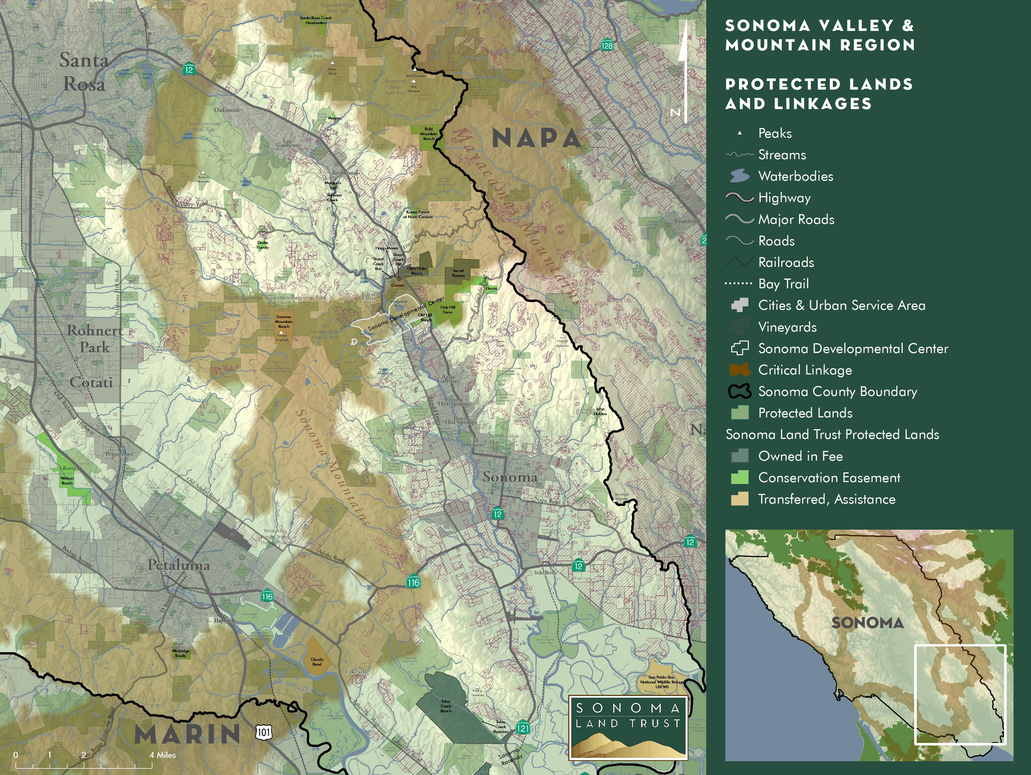
Protected Lands and Linkages in southern Sonoma County with elevation data from the Sonoma County Veg Map Project
and linkage information from the Bay Area Critical Linkages
Joseph Kinyon, Sonoma Land Trust
These studies of critical linkages are fueled by an interest in protecting the beautiful, natural, agricultural and open lands that distinguish Sonoma County as well as its wildlife. All this work, supported by the Gordon and Betty Moore Foundation as well as members and volunteers of Sonoma Land Trust, aim at answering questions such as:
- Are wild animals currently able to traverse the corridor?
- Do animals get killed by traffic when attempting to cross roads that intersect with wildlife corridors?
- Can we determine if some places are bottlenecks that are essential to maintaining corridors and if lost or subdivided would close a remaining essential pathway?
Understanding the above is important to the conservation efforts of the Sonoma Land Trust, but this information is also useful for agencies maintaining roads so that they can choose where wildlife passages need to be located or improved.
The importance of field observations and public engagement
A major wildlife corridor identified by the Bay Area Critical Linkage analysis connects the Mayacamas Mountains across to Sonoma Mountain and on to Marin County. A narrow portion of the corridor crosses Sonoma Valley near Glen Ellen. Tucked between towns and vineyards where it intersects both a state highway and arterial road, the corridor crosses almost perpendicular to those highly traveled roads.
.jpg)
Sonoma Valley Wildlife Corridor with elevation data from the Sonoma County Veg Map project
and linkage information from the Bay Area Critical Linkages.
Joseph Kinyon, Sonoma Land Trust
You can read more about Sonoma Land Trust’s work in this area Keeping the Sonoma Valley Wildlife Corridor Open and Wildlife Friendly and Sonoma Valley Wildlife Corridor Project; Management and Monitoring Strategy
To validate wildlife corridor models as well as to measure the impact of intersecting roads, evidence from the field is required. Field observations are needed to understand if animals move through the modeled corridors as mapped. Data from field observations are also needed to understand spatial and temporal patterns that will ultimately guide conservation decisions in land protection and wildlife management.
Given that much of the land in the study area is in private hands, field work needs the commitment of the very same people that live there.
Tony Nelson in the Stewardship Department of Sonoma Land Trust coordinated with neighboring land owners. With his staff and partners they distributed an array of cameras across the landscape to observe if any animals were active in the predicted corridor. To complement the landscape camera data, cameras where placed at road underpasses (bridges and culverts). In addition to cameras, an effort to document roadkill observations in the same region was made.
.JPG)
Gray fox adults near Glen Ellen, California
Sonoma Land Trust.jpg)
Sonoma Land Trust staff recording roadkill observation in Sonoma Valley,
Jen Stanfield, Sonoma Land Trust
The importance of choosing the right tools for field observations
The theory behind a systematic survey of wildlife roadkill observations is simple: document animals killed while attempting to cross the road, identify the species, approximate time of the event, exact location and other related details.
An effective roadkill survey can be compromised if the wrong methods and tools are used to capture information. To be successful, field observers need tools that make the data collection effort easy, accurate and quick.
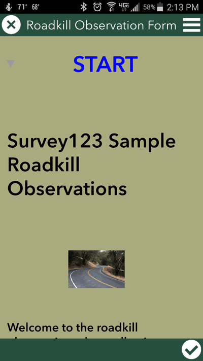
After exploring different options, at Sonoma Land Trust chose the Survey123 for ArcGIS mobile application to support the roadkill observation efforts. Survey123 proved to be:
- Easy: Field observers found the mobile application intuitive. With little training, Sonoma Land Trust’s staff and partners were able to effectively create the mobile form and capture all the essential data to document a roadkill. The task of finding a user friendly field data collection tool is not to be underestimated because the field is where most data collection efforts fail.
- Accurate: Unlike paper forms which can have incomplete and erroneous data (even by trained professionals) through Survey123 we were able to build smart user input data validation rules that helped standardize incoming observations and eliminated the process of transcribing paper forms and interpreting a variety of handwriting. In my career, I’ve seen some research never clear the hurdle of transcribing paper forms into a database. It stymies citizen science efforts as well.
- Quick: Survey123 is an all-in-one solution where field observers can quickly select the species identified, capture a photo, and obtain an accurate location of the event using their mobile phone’s GPS. Most importantly, the data can be submitted for analysis immediately, so the chances for delays delivering information captured or for complete loss of the form are eliminated.
Safety is always a concern. Whenever making an observation about a dead animal in the middle of the road, always remember that you are also an animal in the middle of the road. If it is unsafe, you can always come back; the animal isn’t going anywhere soon, don’t become a new roadkill observation. Collecting data quickly is critical to the workflow.
Recording observations and measurements are the backbone of this effort. Field observations are like detective work capturing details about who, what, when and where. Take all the observations in a systematic way while following a clear protocol, and you record data that can more easily become information sorted into patterns for analysis. This furthers you down the path to evidence based decision making and action.
Our Roadkill smart form, Tricks of the trade.
Sonoma Land Trust created a form using Survey123 Connect and Microsoft Excel. An abbreviated version of that form without our logo, branding and internal staff information is available for users to download and adapt for their needs or simply borrow solutions useful for projects unrelated to roadkill observations.
Here’s a quick animated summary of using the form, completing prompted questions, and submitting an observation in the Survey123 mobile application.
Install Survey123 on your desktop or mobile device using these links and download the roadkill sample form shown above to your device to test and try out how easy it is to work with that template.
There are some fantastic features of the Survey123 app that enhance the ease of use, maintain the quality of the data collected and make the data collection process quicker. These were essential to our reasoning to shift to using these tools. I’ll highlight a few of the ones that improved quality and efficiency in the following sections starting with lists and autocomplete.
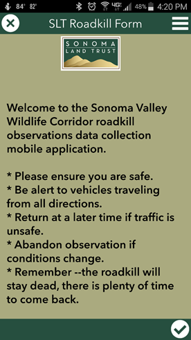
SLT Roadkill Form intro in the Survey123 mobile app
Sonoma Land Trust
Lists and Autocomplete
Choice lists and Autocomplete alone make Survey123 better than paper forms
After a short time, my thumbs are tired from the button gymnastics they perform. I can’t really count on special thumb training at the gym to improve this, so I want to make the number of entries I or a user makes, to be as few and accurate as possible.
With a dropdown list of observer names, the “who observed this roadkill?” portion is quickly completed and the spelling of the name is consistent. For example, an observer name selected this way is always recorded as “John Doe” when added to the observation. A data manager never again needs to decrypt from a paper form whether the name written as J.D., Johnny D., J. Doe, John D., Jon Do, or [indecipherable scribble] actually means “John Doe.”
Another convenience is that if the dropdown list of observer names is long, the user can type in a few letters of their name and the app will filter and present an abbreviated list to quickly scroll through and choose from. Keep typing and one choice remains to complete entry of the name.
Display only what you need to complete
The identification of type of animal killed is chosen from a list of species. We wanted the data to be useful to other organizations and eliminate problems associated with joining related data across imperfect matches. To do that we added questions and structured our data to include all the components that the California Roadkill Observation System (CROS) uses for ease in appending our observations to their larger data set in the future.
Our list of vertebrates is pulled directly from the CROS species list for conformity of spelling and it uses their unique ID to store it. To improve workflow, we repeated the usual critters we encounter at the top of the dropdown selection list in our form so that finding “striped skunk” is a quick task during the usual mating season of January and February. “Seal” stays way down the list where it is easily found if ever needed.
To learn more about the California Roadkill Observation System (CROS) operated out of UC Davis please see their website.
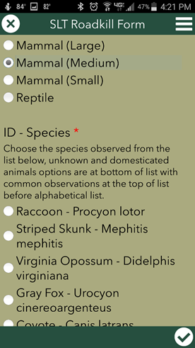
Select the name of the species observed.
Sonoma Land Trust
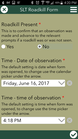
An especially elegant part of Survey123 (and the XLSForm specifications it uses) is the “relevant” display of sections of the form. Single questions or whole sections of the form can appear or collapse based upon a previous answer, prompting what is required and bypassing questions that are irrelevant. This speeds up the data collection task pragmatically without rushing it. Large and complex paper forms are encumbered by this breakup of the flow of the form. Observers who have forms that allow for big blank or unanswered sections have a harder time checking if they completed all the required questions which can result in incomplete essential data.
With the Sonoma Land Trust Roadkill Observation form protocol, if a staff member goes out to make a roadkill observation on a regular basis, but doesn’t encounter any, that effort is still important to know. The app user that observes no roadkill automatically skips all prompts for identification of the animal, its picture and coordinates. In the Excel spreadsheet that I use to author the form, I mark the portions of the form that need to be shown contingent to a prior answer, and Survey123 Connect automatically converts this into the form’s code.
If the app user has seen roadkill, the ID Category appears. Choosing one of these categories is a very coarse form of identification and this step reduces the huge list of vertebrates and presents a much smaller set of possible species. This technique is called a cascading select that makes choosing counties limited to a state or user names by a department very easy to implement
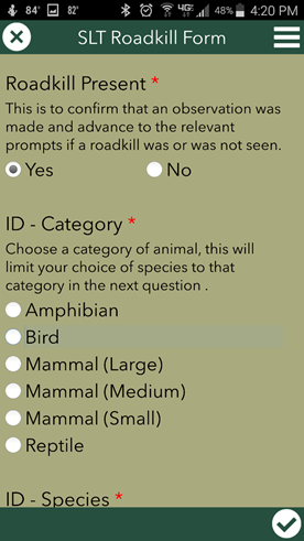
Section of form showing section that appears when relevant.
The identification of roadkill section doesn’t appear (screenshot on right)
unless the observer selects “Yes” and confirms that there was roadkill present.
Sonoma Land Trust.
Take advantage of the technology
The computational power of mobile devices the built-in sensors and optional connected devices can further automate and synchronize work.
By default, on our form the current time and date is automatically entered based on the mobile device’s clock. The user can also quickly edit with a graphical calendar or clock to select the time stamp they need.
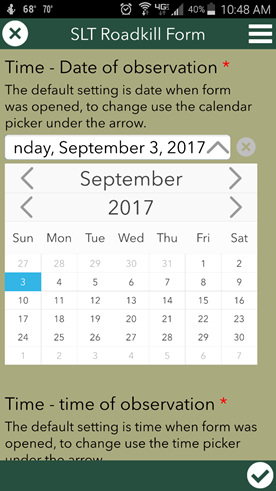
Date Picker screenshot
Sonoma Land Trust
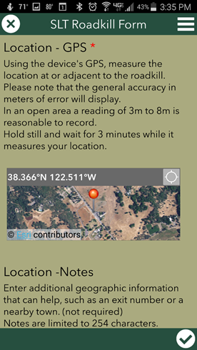
When a user completes the geopoint question type in Survey123, the location where the roadkill was observed is entered into the form using the coordinates provided by the GPS (either as an instant reading or an averaged point). The accuracy of GPS for navigating roads using a mobile device such as a smartphone is also sufficient for measuring the location of a dead animal along those roads. With most smartphones and tablets, we can expect our accuracy to be within 5 meters and can use the averaging tool inside Survey123 to improve our confidence in that measurement. In order to minimize the time needed for our final location measurement and roadkill photo we try to stand off the road, complete other parts of the form first, and get a first fix of location before stepping out next to the animal for a final location and picture.
We use the GPS generated points along roads for our location information because we don’t anticipate repeating the observation in the same spot over and over. However, if we wanted to collect repeated observations for a specific or predetermined location or section of road, we can map them with Collector for ArcGIS, and then return to that location or line segment using Collector on the same device which will automatically populate the Survey123 form for that section of road using a custom URL scheme connected to that feature.
Geopoint tool that uses device’s GPS data or map locator.
Sonoma Land Trust
The screenshot above was made while connected to a cellular data network. In addition to using the coordinates provided by the GPS the user can pick the location to enter into the form from a georeferenced image. However, our county has limited cell phone data access. We can anticipate no aerial imagery or map being displayed if the geopoint question is viewed while off a data network. We can avoid this by pre-loading a cache of basemaps (Tile Package) with road names, parcel boundaries, and/or high resolution aerial imagery of the area over WiFi in our office before departing
Survey123 can access the mobile device’s built-in camera to add multimedia data to the observation(s). We complement the species ID with a photo of the roadkill. The camera can also be used to scan barcodes and QR codes for tracking tagged objects.
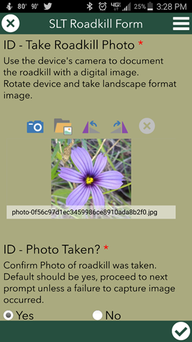
Photo tool that uses device’s camera
Sonoma Land Trust, Blue Eyed Grass (much nicer than a roadkill shot) by Joseph Kinyon
For other tools we have built using Survey123, we found that if we are connected to a network, the user can use voice to text conversion built into the device’s keyboard (e.g. Samsung Note phones and tablets) to automatically transcribe dictated notes or promote correct spelling when typing or writing in a notes field.
Excel sheet editing
When we began using Survey123 all form designs were done via an Excel Spreadsheet. Some of the more advanced functions are still only available by editing an Excel workbook in Survey123 Connect, however there is now an online form builder tool for creating them quickly. To see how we solved many of our form design challenges, checkout the Excel document here.
The Payoff
Once the observation of a roadkill is made on the form, here is the sweet part of Survey123--no paper data to transcribe.
The observer reviews their entries and can send the data immediately to our ArcGIS Online organization via the device’s cell/mobile data connection or when back on a trusted Wi-Fi network. Once sent, it is available to review instantly.
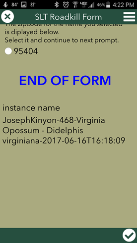
End of form, ready to submit
Sonoma Land Trust
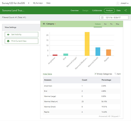
On the Survey123 website I can login and review the data immediately, getting a sense of trends and patterns as they emerge. For example, using the built in reporting capabilities in the Survey123 website, it is easy to see some clustering of roadkill observations made between November 2016 and May 2017 along a road near the City of Petaluma. We can also see that medium sized mammals (yellow bar in screenshot below) are represented in the data far more than other animals.
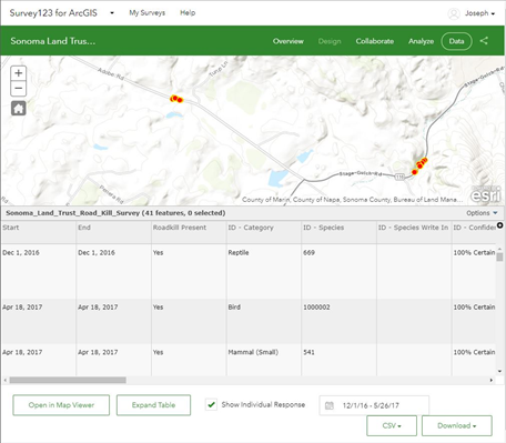
Survey123 web tools to review data
Sonoma Land Trust / ESRI
Survey123 web of the shelf tools to review and analyze data
Sonoma Land Trust / ESRI
Since the data is available as a feature layer in ArcGIS Online, after reviewing it online we can download or archive snapshots as a file geodatabase or add the data directly to ArcGIS Desktop or ArcGIS Pro project for further analysis, mapping, and communication.
What we do with what we learned
We get to the step where we visualize our data on a map much sooner. The design of the form, formatting requirements, and data entry efficiencies augment the workflow. We get to the analysis and mapping stage quicker because the time to make corrections of gross error or gaps during data entry of paper records is almost eliminated. Since the majority of our funding is from donations and grants supporting our work, the hours saved are part of our regular effort to increase the reach of limited dollars for conservation.
Land conservation requires awareness of opportunities and acting strategically in both the short and long term. To purchase a land parcel that comes up for sale or to collaborate with land owners to help maintain or improve their land and the habitat it provides is a long relationship of good timing. We can focus on protecting places that appear to be bottlenecks or parcels that are essential to maintaining wildlife corridors and links—especially parcels where development might ignore the needs of wildlife and could close a remaining or critical wildlife path.
By collecting roadkill data we add that information into our decision making process. We focus on parcels for protection when they appear to maintain connectivity and provide the pathways for animals to move between places. The observations can also inform future design or retrofit of culverts or underpasses that enhance the passage of wildlife between lands divided by a road. Land conservation is a discipline of finding opportunities. We want to protect existing quality habitat, maintain the connectivity between landscapes and restore or enhance places for improving quality of life for living things, including us. We strategize and collaborate to leverage our resources. But there aren’t enough dollars or staff to do all the projects we want or when some opportunities appear, so we prioritize our spending and efforts. By bits and pieces, parcel by parcel, we do our work to conserve large landscapes. By bits and pieces on a form, we collect observations and measurements to create the data to inform that work.
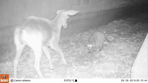
Deer and Raccoon rendezvous
Sonoma Land Trust
Joseph Kinyon is the GIS Manager for Sonoma Land Trust, a not for profit land conservation organization in Northern California. Joseph has been working with GIS since the late 90’s. At the Sonoma Land Trust his work managing the five components of any GIS includes supporting the people, software, hardware, data and methods that Sonoma Land Trust uses in the acquisition and stewardship of agricultural and wild lands for conservation. Joseph loves forests and his joy in reducing paperwork starts with reducing our need to cut trees down to make it.
You must be a registered user to add a comment. If you've already registered, sign in. Otherwise, register and sign in.