Turn on suggestions
Auto-suggest helps you quickly narrow down your search results by suggesting possible matches as you type.
Cancel
- Home
- :
- All Communities
- :
- Products
- :
- ArcGIS Spatial Analyst
- :
- ArcGIS Spatial Analyst Questions
- :
- Re: Why these two rasters can�??t be summed up?
Options
- Subscribe to RSS Feed
- Mark Topic as New
- Mark Topic as Read
- Float this Topic for Current User
- Bookmark
- Subscribe
- Mute
- Printer Friendly Page
06-06-2012
10:53 AM
- Mark as New
- Bookmark
- Subscribe
- Mute
- Subscribe to RSS Feed
- Permalink
Why these two rasters can???t be summed up?
I???m wondering why the two raster shown in the screenshot below cannot be summed up?
What might be the reason?
[ATTACH=CONFIG]14987[/ATTACH]
Thank you for the help,
Best
Jamal
I???m wondering why the two raster shown in the screenshot below cannot be summed up?
What might be the reason?
[ATTACH=CONFIG]14987[/ATTACH]
Thank you for the help,
Best
Jamal
----------------------------------------
Jamal Numan
Geomolg Geoportal for Spatial Information
Ramallah, West Bank, Palestine
Jamal Numan
Geomolg Geoportal for Spatial Information
Ramallah, West Bank, Palestine
Solved! Go to Solution.
15 Replies
06-06-2012
02:03 PM
- Mark as New
- Bookmark
- Subscribe
- Mute
- Subscribe to RSS Feed
- Permalink
try sending your output to a folder rather than a geodatabase
also ensure that both files have the same projection
also ensure that both files have the same projection
06-06-2012
02:15 PM
- Mark as New
- Bookmark
- Subscribe
- Mute
- Subscribe to RSS Feed
- Permalink
Writing to the default geodatabase should be fine, but you could try GRID if you want. The rasters do not have to have the same projection either, although recommended. What is more revealing to me is the geodatabase you provided. There is only the A raster which isn't one your trying to add, but nonetheless I noticed that it doesn't have a spatial referenced defined. Also, I went back to your screenshots and noticed that even though Elevation is the 3rd layer in the map, it is always the raster being shown behind the other dialogs that are open. This begs the question...Does B even line up with Elevation? Or is too much of the display being hid by the other dialogs in your screenshots to see that B is a subset of Elevation?
Eric
Eric
06-06-2012
02:36 PM
- Mark as New
- Bookmark
- Subscribe
- Mute
- Subscribe to RSS Feed
- Permalink
Jamal,
One more thing. I looked up the nested error, "Error 010422" and found it is related to the Mask setting in the environment settings. So even if B does line up with Elevation, if you have a mask set in the environments for some other location that doesn't overlap either B or Elevation, the tool would fail with this error.
http://resourcesbeta.arcgis.com/en/help/main/10.1/index.html#//00vq0000000s010422
Eric
06-07-2012
01:47 PM
- Mark as New
- Bookmark
- Subscribe
- Mute
- Subscribe to RSS Feed
- Permalink
try sending your output to a folder rather than a geodatabase
also ensure that both files have the same projection
Many thanks.
Quite frustrating.
I set the output to be in a folder,
[ATTACH=CONFIG]15046[/ATTACH]
I make the two raster on the same coordinate system
[ATTACH=CONFIG]15049[/ATTACH]
But still the error is there!!!!
[ATTACH=CONFIG]15047[/ATTACH]
What might be further there?
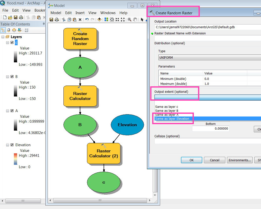
it remains to say that the B raster is derived from the "create random raster", does this matter?
[ATTACH=CONFIG]15048[/ATTACH]
----------------------------------------
Jamal Numan
Geomolg Geoportal for Spatial Information
Ramallah, West Bank, Palestine
Jamal Numan
Geomolg Geoportal for Spatial Information
Ramallah, West Bank, Palestine
06-07-2012
02:02 PM
- Mark as New
- Bookmark
- Subscribe
- Mute
- Subscribe to RSS Feed
- Permalink
Jamal,
Please send a screenshot of 'B' layer properties so I can see the extent values. Please do the same for Elevation. What happens if you add Elevation to a blank map, then add B to it? Does B overlay Elevation? If layer B has the same extent values as layer A that you uploaded to this forum, that would explain the issue. You can't add two rasters together if they don't line up with one another.
Eric
06-07-2012
02:24 PM
- Mark as New
- Bookmark
- Subscribe
- Mute
- Subscribe to RSS Feed
- Permalink
Jamal,
Please send a screenshot of 'B' layer properties so I can see the extent values. Please do the same for Elevation. What happens if you add Elevation to a blank map, then add B to it? Does B overlay Elevation? If layer B has the same extent values as layer A that you uploaded to this forum, that would explain the issue. You can't add two rasters together if they don't line up with one another.
Eric
Thanks a million! My issue is solved.
The problem that the created random layer is not lined up with the elevation raster (as you have advised)! I have to set the extent of the �??random raster�?� to be the same as the elevation raster!
Now it is working!
Appreciated
Jamal
[ATTACH=CONFIG]15050[/ATTACH]
----------------------------------------
Jamal Numan
Geomolg Geoportal for Spatial Information
Ramallah, West Bank, Palestine
Jamal Numan
Geomolg Geoportal for Spatial Information
Ramallah, West Bank, Palestine
- « Previous
-
- 1
- 2
- Next »
- « Previous
-
- 1
- 2
- Next »