Turn on suggestions
Auto-suggest helps you quickly narrow down your search results by suggesting possible matches as you type.
Cancel
- Home
- :
- All Communities
- :
- Products
- :
- ArcGIS Spatial Analyst
- :
- ArcGIS Spatial Analyst Questions
- :
- why the "Raster to polygon" tool takes o...
Options
- Subscribe to RSS Feed
- Mark Topic as New
- Mark Topic as Read
- Float this Topic for Current User
- Bookmark
- Subscribe
- Mute
- Printer Friendly Page
why the "Raster to polygon" tool takes only the fields that contain real numbers?
Subscribe
2786
9
05-26-2011 11:31 AM
05-26-2011
11:31 AM
- Mark as New
- Bookmark
- Subscribe
- Mute
- Subscribe to RSS Feed
- Permalink
sorry for the mistake in the title of this post. it should be: why the "Raster to polygon" tool takes only the fields that contain integer numbers?
Does the tool "Raster to polygon" take only the fields that contain only integer number?
please, see the attached image that shows my question
why the "Raster to polygon" tool takes only the fields that contain real numbers?
what i should do if i have a field that contain Real number?
what's wrong with the real numbers???
than you
regards
Jamal
----------------------------------------
Jamal Numan
Geomolg Geoportal for Spatial Information
Ramallah, West Bank, Palestine
Jamal Numan
Geomolg Geoportal for Spatial Information
Ramallah, West Bank, Palestine
9 Replies
05-26-2011
01:29 PM
- Mark as New
- Bookmark
- Subscribe
- Mute
- Subscribe to RSS Feed
- Permalink
What is the Type for this field? Is it String, Short, Long, Float, Double?
05-26-2011
01:35 PM
- Mark as New
- Bookmark
- Subscribe
- Mute
- Subscribe to RSS Feed
- Permalink
What is the Type for this field? Is it String, Short, Long, Float, Double?
it is double.
----------------------------------------
Jamal Numan
Geomolg Geoportal for Spatial Information
Ramallah, West Bank, Palestine
Jamal Numan
Geomolg Geoportal for Spatial Information
Ramallah, West Bank, Palestine
05-26-2011
01:53 PM
- Mark as New
- Bookmark
- Subscribe
- Mute
- Subscribe to RSS Feed
- Permalink
Don't know why I asked if it was short or long, because you obviously have decimals in there.
As for why it doesn't work, when I asked early looked at the wrong Help. I accidentally looked up the help for polygon to raster, which will use float or integer.
Raster to Polygon only uses integer or string.
raster_field (Optional)
The field used to assign values from the cells in the input raster to the polygons in the output dataset.
It can be an integer or a string field.
http://help.arcgis.com/en/arcgisdesktop/10.0/help/index.html#//001200000008000000.htm
05-26-2011
02:12 PM
- Mark as New
- Bookmark
- Subscribe
- Mute
- Subscribe to RSS Feed
- Permalink
Don't know why I asked if it was short or long, because you obviously have decimals in there.
As for why it doesn't work, when I asked early looked at the wrong Help. I accidentally looked up the help for polygon to raster, which will use float or integer.
Raster to Polygon only uses integer or string.
raster_field (Optional)
The field used to assign values from the cells in the input raster to the polygons in the output dataset.
It can be an integer or a string field.
http://help.arcgis.com/en/arcgisdesktop/10.0/help/index.html#//001200000008000000.htm
It is SP2.
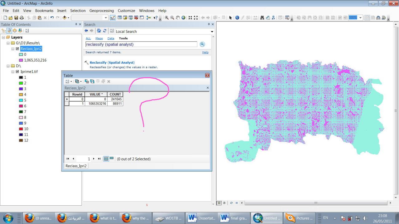
I'm not sure also why when we reclassify according the Iprime then the result is irrelevant!!! (attached)
----------------------------------------
Jamal Numan
Geomolg Geoportal for Spatial Information
Ramallah, West Bank, Palestine
Jamal Numan
Geomolg Geoportal for Spatial Information
Ramallah, West Bank, Palestine
05-26-2011
02:22 PM
- Mark as New
- Bookmark
- Subscribe
- Mute
- Subscribe to RSS Feed
- Permalink
e input raster can have any cell size and must be a valid integer raster dataset.
from the version 10 help files...check other versions if you aren't using ArcGIS 10
05-26-2011
02:34 PM
- Mark as New
- Bookmark
- Subscribe
- Mute
- Subscribe to RSS Feed
- Permalink
Raster to Polygon only takes integer (or string) - period.
This is by design since 9.0
The reason is that too many individual polygons will be created in most cases.
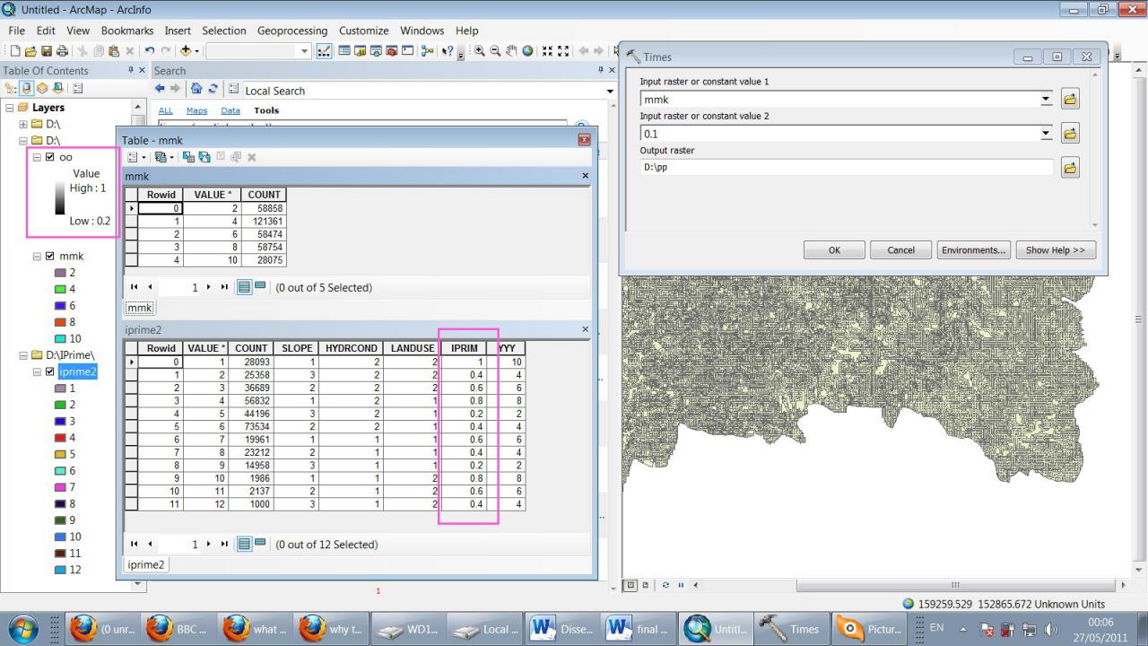
In the case where one really wants float output, then can multiply the raster by, say 1000, and cast to integer, convert and then divide by 1000. This workflow has been repeated many, many times in this Forum.
Steve
This is by design since 9.0
The reason is that too many individual polygons will be created in most cases.
In the case where one really wants float output, then can multiply the raster by, say 1000, and cast to integer, convert and then divide by 1000. This workflow has been repeated many, many times in this Forum.
Steve
05-26-2011
03:14 PM
- Mark as New
- Bookmark
- Subscribe
- Mute
- Subscribe to RSS Feed
- Permalink
Raster to Polygon only takes integer (or string) - period.
This is by design since 9.0
The reason is that too many individual polygons will be created in most cases.
In the case where one really wants float output, then can multiply the raster by, say 1000, and cast to integer, convert and then divide by 1000. This workflow has been repeated many, many times in this Forum.
Steve
Thank you for the answer.
this problem is originated from trying to dissolve the raster (attached image) according the Iprime field.
i was trying to have a dissolved raster with 5 values: 0.2, 0.4, 0.6, 0.8 and 1. but i couldn't find any tool to accomplish this task.
i got a suggestion to convert the raster to polygons then the ploygons to raster to achieve the dissolve!!!!! nevertheless, the problem is again there. i couldn't obtain a dissolved raster with the values 0.2, 0.4, 0.6, 0.8 and 1
basically, how can i dissolve the raster according the Iprime field?
----------------------------------------
Jamal Numan
Geomolg Geoportal for Spatial Information
Ramallah, West Bank, Palestine
Jamal Numan
Geomolg Geoportal for Spatial Information
Ramallah, West Bank, Palestine
05-26-2011
03:27 PM
- Mark as New
- Bookmark
- Subscribe
- Mute
- Subscribe to RSS Feed
- Permalink
Try some of the other suggestions then, there have been several others but you appear to be fixed on one, is there a reason?
05-26-2011
03:34 PM
- Mark as New
- Bookmark
- Subscribe
- Mute
- Subscribe to RSS Feed
- Permalink
Try some of the other suggestions then, there have been several others but you appear to be fixed on one, is there a reason?
at all. this is the only suggestion that i got.
do you have any?
----------------------------------------
Jamal Numan
Geomolg Geoportal for Spatial Information
Ramallah, West Bank, Palestine
Jamal Numan
Geomolg Geoportal for Spatial Information
Ramallah, West Bank, Palestine