Turn on suggestions
Auto-suggest helps you quickly narrow down your search results by suggesting possible matches as you type.
Cancel
- Home
- :
- All Communities
- :
- Products
- :
- ArcGIS Spatial Analyst
- :
- ArcGIS Spatial Analyst Questions
- :
- Volume of dams at differing elevations
Options
- Subscribe to RSS Feed
- Mark Topic as New
- Mark Topic as Read
- Float this Topic for Current User
- Bookmark
- Subscribe
- Mute
- Printer Friendly Page
Volume of dams at differing elevations
Subscribe
3556
3
12-19-2012 02:43 PM
12-19-2012
02:43 PM
- Mark as New
- Bookmark
- Subscribe
- Mute
- Subscribe to RSS Feed
- Permalink
Hi,
I'm trying to calculate the potential volume of dams (above the ground/water level) at different elevations/stages (and/or the potential water area). I want to calculate the area and volume at 20 different elevations/stages for each dam and I have up to 50,000 polygons to calculate this for. I have the maximum polygon extent of each dam and a working model in modelbuilder. Each dam takes 30-50sec to calculate the area (the 20 different calculations) , which I can then use to calculate the volume, but runs out of memory when I try to run the tool for only 1,000 dams.
I have tried to use the Surface Volume tool but the tool gives incorrect values (especially the volume calculation). But, I think this tool could really help with the runtimes and memory issue.
I have tried to use the Tabulate Area tool but it has a limited allowable number of fields (approx 200). I am using a integer difference grid.
I have tried the Zonal Histogram tool but it seems to have a field/zone limit as well..?
I am using a 2m DEM and have a difference grid up to the maximum level/stage.
Does anyone have any suggestions?
3 Replies
12-20-2012
07:14 AM
- Mark as New
- Bookmark
- Subscribe
- Mute
- Subscribe to RSS Feed
- Permalink
Try this: Go to Customize/ArcMap Options/Raster and change the maximum number of unique values to render from the default 65536 to (for example) 10000000. In my work with Arc Hydro, this seemed to eliminate errors due to grid size. I'm not sure if there is a maximum number and I'm not sure if making the number high reduces speed for smaller projects.
I hope this may help.
I hope this may help.
12-20-2012
10:23 AM
- Mark as New
- Bookmark
- Subscribe
- Mute
- Subscribe to RSS Feed
- Permalink
Are you trying to deterimine the volume of a dam or the volume of the reservoir?
That should just about do it....
01-13-2013
04:31 PM
- Mark as New
- Bookmark
- Subscribe
- Mute
- Subscribe to RSS Feed
- Permalink
Further to above.
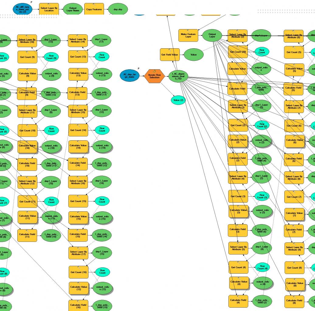
I'm trying to find the potential volume of depressions/dams/sinks in the topography (ie above the DEM) at different elevations above the ground surface. These depression areas are the polygon areas that are filled using the FILL tool and are larger than a minimum size. I need to get the area or volume at up to 20 different elevations (between the lowest elevation within the depression and the filled level of the depression) for each polygon/depression. I have the lowest and largest elevation in each polygon area.
I have attached the model that works but ultimately runs out of memory. It iterates through the polygon areas and counts the number of points above a certain depth (the points shapefile/input is a difference grid converted to points) and outputs it to a field. The Calculate Value tool just checks to see if it is above the max depth of the depression (if so it is NULL and skips to the next iteration).
Does anyone know how I can solve the memory issue? As it runs it just keeps accumulating memory. Is there any way to reset it each iteration or something..?
Any help would be much appreciated!
[ATTACH=CONFIG]20680[/ATTACH]