- Home
- :
- All Communities
- :
- Products
- :
- ArcGIS Spatial Analyst
- :
- ArcGIS Spatial Analyst Questions
- :
- Re: Tool like Point and Line Density for Polygons?
- Subscribe to RSS Feed
- Mark Topic as New
- Mark Topic as Read
- Float this Topic for Current User
- Bookmark
- Subscribe
- Mute
- Printer Friendly Page
Tool like Point and Line Density for Polygons?
- Mark as New
- Bookmark
- Subscribe
- Mute
- Subscribe to RSS Feed
- Permalink
Hello,
I have to calculate a magnitude-per-unit area from polygone-features that fall within a neighborhood around each cell. Is there a tool like Point Density for polygon-features?
Thanks a lot for answering. I'm using ArcGIS 10.3.
Hallo,
ich möchte die Größe pro Flächeneinheit auf Basis von Polygon-Features, die sich innerhalb einer bestimmten Nachbarschaft um eine einzelne Zelle befinden berechnen. Gibt es ein Tool ähnlich wie Point Density auch für Polygone?
Vielen Dank für eine Antwort im Voraus.
Jutta
Solved! Go to Solution.
Accepted Solutions
- Mark as New
- Bookmark
- Subscribe
- Mute
- Subscribe to RSS Feed
- Permalink
Interesting... this starts to sound more like a Focal Statistics operation (see: How Focal Statistics works—Help | ArcGIS for Desktop ) where you use the SUM operator on a raster where each cell has that belongs to a polygon has the value of the area (1ha) or simply use the value 1 and know that the resulting sum is expressed in hectares. And on the other hand counting the number of different cells (Variety) of a raster that has unique values for each polygon (is the raster does not have this you could try Region Group—Help | ArcGIS for Desktop (unless polygons connect)
- Mark as New
- Bookmark
- Subscribe
- Mute
- Subscribe to RSS Feed
- Permalink
Do you have a screenshot of the data? Are you interested in counting overlaps of polygons? Or is creating random points inside the polygons based on the magnitude value an option so you can perform the Point (or Kernel) density?
- Mark as New
- Bookmark
- Subscribe
- Mute
- Subscribe to RSS Feed
- Permalink
I need the same like the output of the line or point density but for polygenes. And I need the polygons and not points out of the polygons, so this is unfortunately no option. What I need is a neighborhood (circle) from 1000 meters and how many polygons are in this neighborhood relating to the whole area.
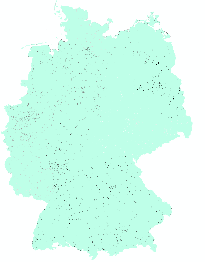
The area is whole Germany and the polygons are resting places and parking sites.
Thanks for answering
- Mark as New
- Bookmark
- Subscribe
- Mute
- Subscribe to RSS Feed
- Permalink
Do you have a visual of what you are trying to do? Could you provide a screen shot?
- Mark as New
- Bookmark
- Subscribe
- Mute
- Subscribe to RSS Feed
- Permalink
If your not interested in overlaps you may be interested in Feature To Point—Help | ArcGIS for Desktop then do your density analysis.
- Mark as New
- Bookmark
- Subscribe
- Mute
- Subscribe to RSS Feed
- Permalink
Perhaps I should make a fishnet, intersect the polygons with the fishnet, and then feature to point. So I get more points depending how big an area is. Then I can use the tool point density with variety. I have to make other analyses with the result.
- Mark as New
- Bookmark
- Subscribe
- Mute
- Subscribe to RSS Feed
- Permalink
Could you share a screenshot of a small area with some polygons (labeled with the value you would like to include in the analysis)? You can use a Fishnet, union and then aggregate per fishnet polygon, but maybe it is nicer to have the smoother effect of Kernel Density. What resolution (pixel size) are you planning to use for the entire extent of Germany?
- Mark as New
- Bookmark
- Subscribe
- Mute
- Subscribe to RSS Feed
- Permalink
Here is a shot, the ID of the elements should be the input and it should count how many different features are in a circle but with having the whole area as basis.
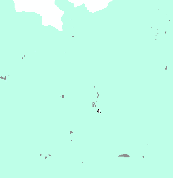
- The pixel size is 100x100 meters, so quite a lot for whole Germany. Kernel density is not an option, because I do same point density’s with point-features as input and like to sum (cell stat) the point density with the density of the polygons (when I know how to do itJ).
- Mark as New
- Bookmark
- Subscribe
- Mute
- Subscribe to RSS Feed
- Permalink
Interesting... this starts to sound more like a Focal Statistics operation (see: How Focal Statistics works—Help | ArcGIS for Desktop ) where you use the SUM operator on a raster where each cell has that belongs to a polygon has the value of the area (1ha) or simply use the value 1 and know that the resulting sum is expressed in hectares. And on the other hand counting the number of different cells (Variety) of a raster that has unique values for each polygon (is the raster does not have this you could try Region Group—Help | ArcGIS for Desktop (unless polygons connect)
- Mark as New
- Bookmark
- Subscribe
- Mute
- Subscribe to RSS Feed
- Permalink
Thanks a lot for your answer. This is what I also did. I made a raster out of the polygon-feature. This is my input for the focal statistic with variety over an id-field which I had to create for the raster. I used also the tool focal statistic with sum for the whole area. The last step was to divide the focal stat from the raster (out of the polygones) with the focal stat (from the whole area).