- Home
- :
- All Communities
- :
- Products
- :
- ArcGIS Spatial Analyst
- :
- ArcGIS Spatial Analyst Questions
- :
- Sum of polylines within each Fishnet grid
- Subscribe to RSS Feed
- Mark Topic as New
- Mark Topic as Read
- Float this Topic for Current User
- Bookmark
- Subscribe
- Mute
- Printer Friendly Page
- Mark as New
- Bookmark
- Subscribe
- Mute
- Subscribe to RSS Feed
- Permalink
Hi,
I need to calculate the total length of paths within each 1km square grid (created with the Fishnet tool). The total length will then be used to rank each grid, depending on the total length distance inside.
I have already used the Intersect tool to ensure the paths do not go through any of the grid borders.
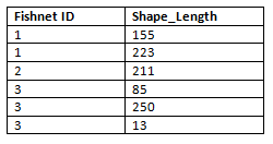
How do I now combine the separate lengths within each grid? See example dataset below. I would like it to show:
Fishnet ID :1
Shape_Length: 378
Thanks,
Ceri
(I am using ArcMap 10.4.1)
Solved! Go to Solution.
Accepted Solutions
- Mark as New
- Bookmark
- Subscribe
- Mute
- Subscribe to RSS Feed
- Permalink
If you already have the table, aren't you just looking for a way to summarize it?
- Mark as New
- Bookmark
- Subscribe
- Mute
- Subscribe to RSS Feed
- Permalink
Hi Ceri
You need to do a spatial join,joining up your trails to your fishnet layer. Right-click on fishnet layer, Joins and Relates > Joins ... Ensure you select the "Join data from another layer based on spatial location" option, and "Each polygon will be given the numeric attributes of the lines ..." Ensure Sum is checked on.
If you are in a geodatabase, then just use the Shape_Length field. Otherwise you may need to first calculate feature length of the shapefile segments following your intersect.
- Mark as New
- Bookmark
- Subscribe
- Mute
- Subscribe to RSS Feed
- Permalink
If you already have the table, aren't you just looking for a way to summarize it?
- Mark as New
- Bookmark
- Subscribe
- Mute
- Subscribe to RSS Feed
- Permalink
Thanks Dan, yes this was the best option in the end. Cheers