- Home
- :
- All Communities
- :
- Products
- :
- ArcGIS Spatial Analyst
- :
- ArcGIS Spatial Analyst Questions
- :
- Struggling with Smoothing Contour Lines
- Subscribe to RSS Feed
- Mark Topic as New
- Mark Topic as Read
- Float this Topic for Current User
- Bookmark
- Subscribe
- Mute
- Printer Friendly Page
Struggling with Smoothing Contour Lines
- Mark as New
- Bookmark
- Subscribe
- Mute
- Subscribe to RSS Feed
- Permalink
I am working with my middle school kids on a science project (I am the tech teacher with a laser cutter). In class, they are doing relief maps with cardboard. The science teacher has seen some of the stuff that came out of my class, so he challenged me with bathymetric maps cut out on the laser. I have tried everything I can find online, but I can't get the contours to "smooth." Every time I smooth them (increase the neighborhood size in Focal Statistics), I lose some of the bays and inlets...but it is still "jagged."
I have all the DEM data loaded, and have been working with the kids on the elevation intervals...all that is working great.
The issue come when I try to process things in Focal Statistics. I have gone from 1-25 on the neighborhood sizes, tried "rectangle" (and all the others), changed "map" to "cell," changed "mean" to a few of the others, etc. I have probably process the elevations no fewer than 50 times.
The only thing I have not been successful with is Python. I tried some sample scripts I found, but it gave me an error (I am not a programmer...so I an struggling to debug it).
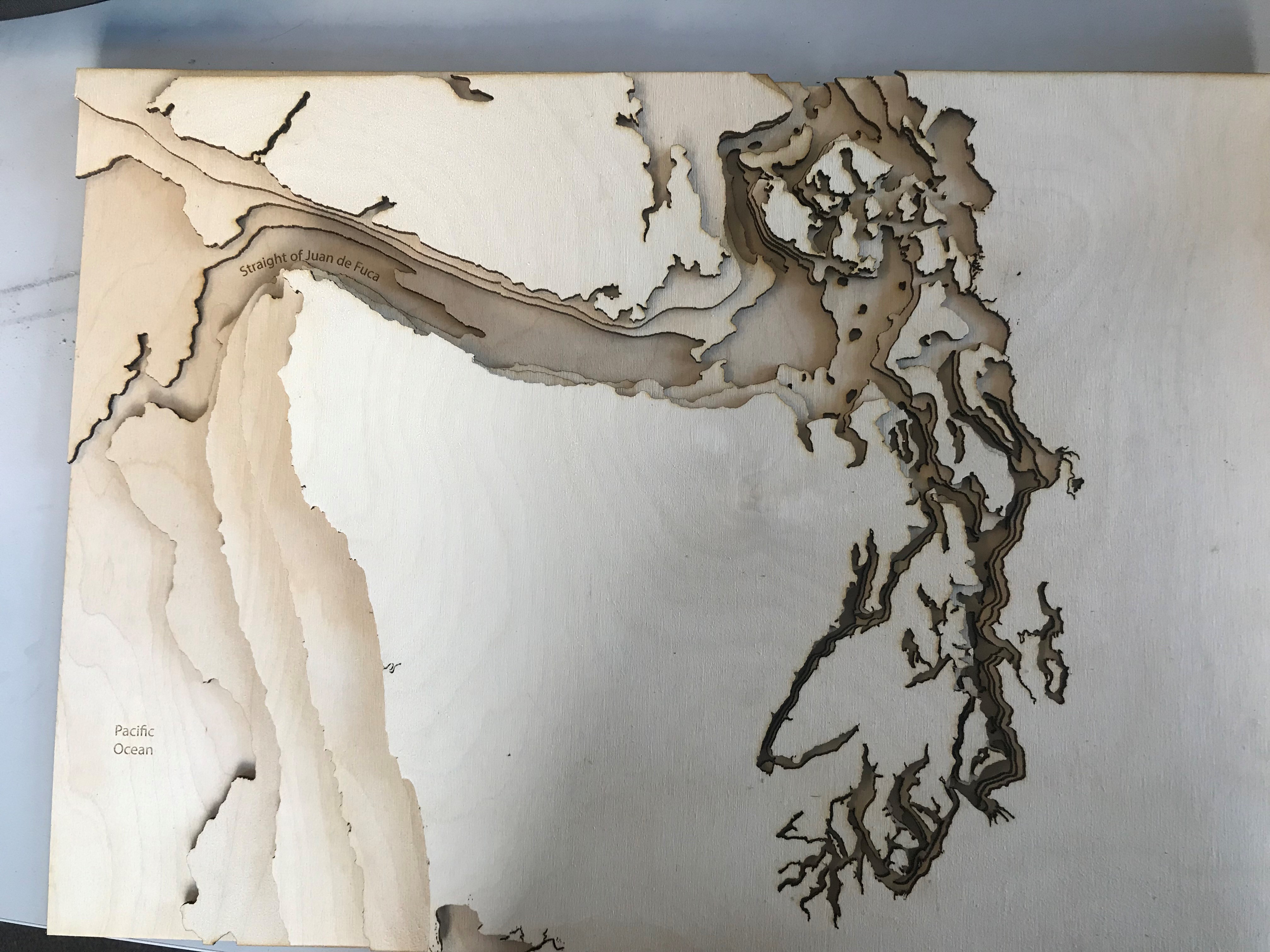
My solution was to export and use my Illustrator skills to smooth things....but I ended up with the "banding" issue. That led me down a whole other rabbit hole. I finally got things "working" and we burned our first map. It is not bad (we like the ruggedness of the lines), but since I was the "lead" on this project, the kids now want to focus on another part of Washington and make their own. The easiest way for the kids to do this is use my DEM data we already processed, but when they zoom into the area of interest, things get VERY pixilated. Since they are 12-14, my goal is to get the ArcMap file dialed in with nice smooth contours (can work with them to customize if needed), export it to AI, then let the kids do their magic from there.
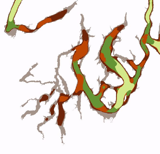
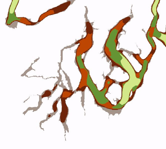
ANY help on how to get these kids going again would be appreciated. I think if I can get smooth contour lines, I will be OK with the rest. The below pictures are:
1. Wide view of the bathymetric contours
2. close-up (not smooth)
3. Same view after changing the neighborhood from 3 to 10...pixels gone...but not smoothed?
4. The project so far
I have been following these instructions as my guide...but I think he uses an older version (I am on 10.6:http://www.instructables.com/id/Lasercut-3D-Topographic-Wood-Maps/
I am hoping it is just something I am overlooking....????
Thanks in advance,
Jeff

-
- Mark as New
- Bookmark
- Subscribe
- Mute
- Subscribe to RSS Feed
- Permalink
I have come across Reclassify, but have not tried that yet. I will do that. Thanks
- Mark as New
- Bookmark
- Subscribe
- Mute
- Subscribe to RSS Feed
- Permalink
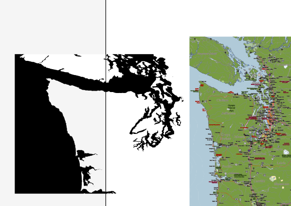
While I try to work on the contour issues, I have also come across another issue. The map of Washington seems to be distorted. I am working with the kids on an "overlay" of rivers, roads, cites, etc. I worked with the overlays on ArcGIS Online, but none were customizable or clear enough for lasering...so I found a vector based map with editable layers. When I tried to overlay them in Illustrator, they do not come close to matching up. I have been looking at the ArcMap image so long, I never realized it was distorted. I am looking into the different projection types, and which coordinate system to use...but a lot of it is unclear to me. Anyone have any "quick fixes" to "straighten" the DEM generated map?
- Mark as New
- Bookmark
- Subscribe
- Mute
- Subscribe to RSS Feed
- Permalink
For reference, here is a screenshot:
- Mark as New
- Bookmark
- Subscribe
- Mute
- Subscribe to RSS Feed
- Permalink
I am trying to create a laser cut map of the state of Idaho. Could you pretend I'm one of your students? Do you have a tutorial or lesson plan you gave them (aside from the in class teaching) that you would be willing to share? I am probably using the wrong search terms but there doesn't seem to be a lot of information out there for how to go about doing this, other than pulling up a google map and tracing each elevation line by hand. I've looked at the thingiverse and instructables tutorials. I have an stl file from one of them to help guide me. However, I'd like to create my own files and I'd like to do most of this digitally. I am mostly proficient in Inkscape so will be layering in there. The final version will be about 56" high and mounted on the wall made with layers of 1/8" baltic birch ply. I might use some other woods too to provide contrast but they will all be about 1/8". I currently want to refrain from stain/paint. I may use blue acrylic for cutting rivers to inlay over as I would like the map to have both topographic and bathymetric relief so some of our lakes may have additional layers showing under the translucent blue acrylic for the water level. I will be splitting each layer's cut file due to size constraints of my laser cutter and am hopeful I can do most of the cuts along a river or highway. Any guidance you have would be appreciated. Thank you, Shishona
- « Previous
-
- 1
- 2
- Next »
- « Previous
-
- 1
- 2
- Next »