- Home
- :
- All Communities
- :
- Products
- :
- ArcGIS Spatial Analyst
- :
- ArcGIS Spatial Analyst Questions
- :
- Re: Raster: Converting digital numbers to real wor...
- Subscribe to RSS Feed
- Mark Topic as New
- Mark Topic as Read
- Float this Topic for Current User
- Bookmark
- Subscribe
- Mute
- Printer Friendly Page
Raster: Converting digital numbers to real world values
- Mark as New
- Bookmark
- Subscribe
- Mute
- Subscribe to RSS Feed
- Permalink
I have downloaded 2 chlorophyll maps which generally have cell values of 0-255.
How can I convert these into real world values?
Following the instructions linked here and here, I have been unable to convert the byte value (0-255) to geophysical values (0-64 mg m3)
Details
I have downloaded L3 choloprhyll data maps. I have extracted and attempted to convert the cell values in R, with no luck.
Is this possible in Arcmap and how would it be achieved?
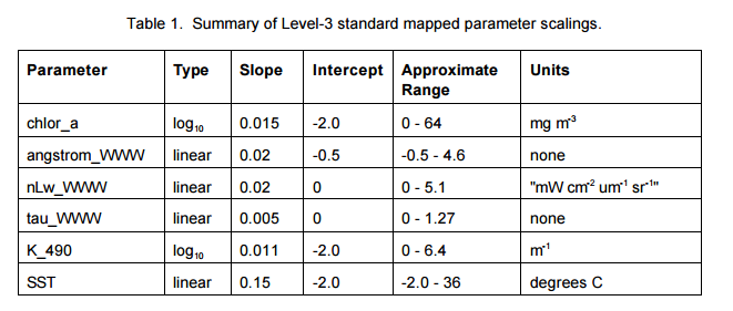
# DN = digital number / cell value / cholorphyll L3 data
# value = 10^[(DN * slope) + intercept]
# raster = Modis cholorphyll sattelite image

# Code ran in R
((values(raster)* 0.015) -2.0)^10)
# Does not return real world values (values between 0-64 mg m-3)
Linked below is one of the raster images I have attempted to convert into real world geophyiscal values, which was downloaded from Giovanni (after clicking the link, click plot, select an image and download as a TIFF. Attachment limits prevent me from directly uploading image. OR just download image attachment in comment below)
Question:
How can I convert the pixel values (0-255) of a cholorphyll L3 TIFF image into real word values, using Arcmap?
- Mark as New
- Bookmark
- Subscribe
- Mute
- Subscribe to RSS Feed
- Permalink
Click image attachment to download TIFF of CHL map.
- Mark as New
- Bookmark
- Subscribe
- Mute
- Subscribe to RSS Feed
- Permalink
python field calculator power x ** y 10**((DN*slope) + intercept)
raster power tool Power—Help | ArcGIS for Desktop
raster calculator **—Spatial Analyst module | ArcGIS for Desktop
- Mark as New
- Bookmark
- Subscribe
- Mute
- Subscribe to RSS Feed
- Permalink
Sorry I'm a little confused. Could you provide an explanation with your comment? Thanks
- Mark as New
- Bookmark
- Subscribe
- Mute
- Subscribe to RSS Feed
- Permalink
I was showing how to implement your equation in either the field calculator, in the spatial analyst , power is implemented in 2 ways.
So what is the question then? Are you trying to figure out how to implement the equation? is so, I provided how to get power (ie ** or Power) You seem to have a DN raster (?) but what about slope and intercept?