- Home
- :
- All Communities
- :
- Products
- :
- ArcGIS Spatial Analyst
- :
- ArcGIS Spatial Analyst Questions
- :
- Re: raster calculator expression box missing - Arc...
- Subscribe to RSS Feed
- Mark Topic as New
- Mark Topic as Read
- Float this Topic for Current User
- Bookmark
- Subscribe
- Mute
- Printer Friendly Page
raster calculator expression box missing - ArcGIS 10
- Mark as New
- Bookmark
- Subscribe
- Mute
- Subscribe to RSS Feed
- Permalink
I have used ArcGIS 10 for couple days. I have a problem with raster calculator. There is no expression box.
From help button, I know that the box suppose to be in between output raster and map expression.
Although I am able to do calculation but I could not see and review what kind formula I wrote.
Is there any way to show the expression box?
Thanks.
Best,
Masalie
Solved! Go to Solution.
Accepted Solutions
- Mark as New
- Bookmark
- Subscribe
- Mute
- Subscribe to RSS Feed
- Permalink
I figured it out! If you lower-and-raise your screen resolution, the raster calculator expression box reappears! I went from 1920x1080 down to 1600x900 and it appeared, and when I went back to 1920x1080 it stayed there! I imagine I'll have to use this hack-solution every time I open arc, but I don't care! It worked for me!
Best Regards,
Dylan
EDIT: EVEN SIMPLER SOLUTION!! (Found by Juan Carlos Villar Calle below, see link >> ArcToolbox - Missing box - YouTube
1. Open up the raster calculator window with the missing expression box)
2. Hold down crtl + scroll your mouse wheel up until it appears! (it must be some issue with the resolution of your screen and resolution of the box... I have no idea... but it works!
3. DONE!!!
Best Regards,
Dylan
- Mark as New
- Bookmark
- Subscribe
- Mute
- Subscribe to RSS Feed
- Permalink
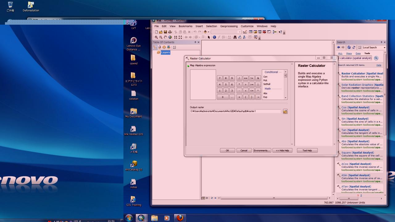
The Raster Calculator is still there, but has moved from the Spatial Analyst toolbar to the Toolbox:
Spatial Analyst Tools\Map Algebra\Raster Calculator
[ATTACH=CONFIG]27864[/ATTACH]
Kind regards,
Xander
- Mark as New
- Bookmark
- Subscribe
- Mute
- Subscribe to RSS Feed
- Permalink
Thank you for your reply. Yes, I open Raster calculator from the ArcToolBox: Spatial Analysis Tools - Map Algebra - Raster calculator.
I have uninstalled ArcGIS and installed it again, however, the situations are the same. I would be glad with any further solution or suggestion. (I may try arcHydro in a few days to go around this problem though.)
Thanks,
Yoshi
- Mark as New
- Bookmark
- Subscribe
- Mute
- Subscribe to RSS Feed
- Permalink
I should have read your question more carefully. In this case I think it is best to contact Esri support and provide all the information about the system you're installing on, the version you're using. Just checked it on my systems and in 10.2 and 10.1 (SP1) I have a working expression window.
The alternative at this moment is to use the Python window in ArcGIS:
What is the Python window?
Example:
import arcpy
from arcpy.sa import *

# myRas = arcpy.Raster('the name of the raster in the TOC or path to raster')
myRas = arcpy.Raster('J000_CumCO2_kgha')

# now you are able to perform any type of raster calculator analysis; like for instance:
myResult = Con(IsNull(myRas),FocalStatistics(myRas,NbrRectangle(5,5,"CELL"),"MEAN","DATA"),myRas)
Some more reading:
Executing tools in the Python window
Kind regards,
Xander
- Mark as New
- Bookmark
- Subscribe
- Mute
- Subscribe to RSS Feed
- Permalink
Thank you for your advice. I will try these methods. I will report again if there will be further problems.
Thanks
Yoshi
- Mark as New
- Bookmark
- Subscribe
- Mute
- Subscribe to RSS Feed
- Permalink
Using Phyton may be a good idea to go around this problem, but the problem is I am a newone for Phyton. What I want to do is as the followings:
1) use raster calcultor to evaluate "raster01 > 5000",
2) in the resulting calculation layer (calc01), resympolize the "0" values to be "No Color" or transparent.
I checked ArcGIS Desktop Help page and tried to use Phyton but might have some mistakes. Any help or suggestion will be welcomed.
>>> import arcpy
>>> from arcpy.sa import *
>>> myRas = arcpy.Raster('raster01')
>>> from arcpy import env
>>> env.workspace="C:\GISdata\workspace"
>>> inRaster="raster01"
>>> "raster01>5000"
'raster01>5000'
>>> arcpy.CheckOutExtension("Spatial")
u'CheckedOut'
>>> Calcuation.save("C:\GISdata\workspace")
Runtime error
Traceback (most recent call last):
File "<string>", line 1, in <module>
NameError: name 'Calcuation' is not defined
- Mark as New
- Bookmark
- Subscribe
- Mute
- Subscribe to RSS Feed
- Permalink
Hello Xander
Using Phyton may be a good idea to go around this problem, but the problem is I am a newone for Phyton. What I want to do is as the followings:
1) use raster calcultor to evaluate "raster01 > 5000",
2) in the resulting calculation layer (calc01), resympolize the "0" values to be "No Color" or transparent.
I checked ArcGIS Desktop Help page and tried to use Phyton but might have some mistakes. Any help or suggestion will be welcomed.
>>> import arcpy
>>> from arcpy.sa import *
>>> myRas = arcpy.Raster('raster01')
>>> from arcpy import env
>>> env.workspace="C:\GISdata\workspace"
>>> inRaster="raster01"
>>> "raster01>5000"
'raster01>5000'
>>> arcpy.CheckOutExtension("Spatial")
u'CheckedOut'
>>> Calcuation.save("C:\GISdata\workspace")
Runtime error
Traceback (most recent call last):
File "<string>", line 1, in <module>
NameError: name 'Calcuation' is not defined
Hi Yoshi,
You're almost there. A few things should be changed.
import arcpy
from arcpy import env
env.workspace = r'C:\GISdata\workspace'
# arcpy.CheckOutExtension("Spatial")
myRas = arcpy.Raster('raster01')
myResult = myRas > 5000
myResult.save('myOutputName')
A few comments on the differences:
- When setting your workspace, use forward slashes, double backslashes or just put an 'r' before the path to avoid errors: env.workspace = r'C:\GISdata\workspace'
- Switching on the Spatial Analyst extension and setting the workspace (Geoprocessing/Environments) can also be done through the menu. The Python window will inherit these settings.
- I assume your TOC holds your input raster "raster01"
- When performing a calculation you need to specify an output (like "myResult"): myResult = myRas > 5000. At this point the SA license should be available.
- When saving the raster you specify the name you want to assign to the raster (example "myOutputName")
- The raster will be stored in the current workspace (in this case "C:\GISdata\workspace")
- The result is a raster with 0 (raster01 <= 5000) and 1 (raster01 > 5000) and NoData cells where the input has Nodata cells.
Kind regards,
Xander
- Mark as New
- Bookmark
- Subscribe
- Mute
- Subscribe to RSS Feed
- Permalink
Thank you very much for your advices. I could go around the Raster calculator window problem. Your explanation of Phyton will be benefitial for someone who encountered similar problem in the future.
Thanks
Yoshi
- Mark as New
- Bookmark
- Subscribe
- Mute
- Subscribe to RSS Feed
- Permalink
I'm glad I could be of any assistance. If you think it was helpful you can use the "arrow" button in order to help other members find useful information:
[ATTACH=CONFIG]27933[/ATTACH]
More info here: http://resources.arcgis.com/en/help/forums-mvp/
Kind regards,
Xander