- Home
- :
- All Communities
- :
- Products
- :
- ArcGIS Spatial Analyst
- :
- ArcGIS Spatial Analyst Questions
- :
- Re: Modify a DEM to a defined elevation.
- Subscribe to RSS Feed
- Mark Topic as New
- Mark Topic as Read
- Float this Topic for Current User
- Bookmark
- Subscribe
- Mute
- Printer Friendly Page
- Mark as New
- Bookmark
- Subscribe
- Mute
- Subscribe to RSS Feed
- Permalink
Hello, I am trying to set a defined elevation to a raster. Meaning, I want to modify a DEM to represent an elevation of 6357 ft. Help?
Solved! Go to Solution.
Accepted Solutions
- Mark as New
- Bookmark
- Subscribe
- Mute
- Subscribe to RSS Feed
- Permalink
Looks great! Glad that worked for ya. The only difference between Mosaic and Mosaic to New Raster is that one creates a new raster. If you feel my answer was correct I'd sure appreciate if you would mark it as such.
- Mark as New
- Bookmark
- Subscribe
- Mute
- Subscribe to RSS Feed
- Permalink
do you want to raise the whole dem so its base is at that level?
do you want to change the values that are at that level?
can you elaborate?
- Mark as New
- Bookmark
- Subscribe
- Mute
- Subscribe to RSS Feed
- Permalink
Use Raster Calculator to add/subtract your desired value.
- Mark as New
- Bookmark
- Subscribe
- Mute
- Subscribe to RSS Feed
- Permalink
that would be a solution, if that were the question... that still hasn't been clarified yet
- Mark as New
- Bookmark
- Subscribe
- Mute
- Subscribe to RSS Feed
- Permalink
Apologies for the confusion. So, I have clipped a segment of a larger DEM and need to decrease the elevation (value) of this clipped area. I have tried Raster Calculator, which works for a blanket increase or decrease value, e.g. subtracting 3 feet from the entire area. However, I need the clipped area to equal one particular value. I'm thinking I need an Algebraic expression in Raster Calculator to assign the value I need but don't quite know how to write it. e.g. Current Elevation - X = Needed Elevation. Does this make sense?
- Mark as New
- Bookmark
- Subscribe
- Mute
- Subscribe to RSS Feed
- Permalink
"clipped_raster" = 6357
- Mark as New
- Bookmark
- Subscribe
- Mute
- Subscribe to RSS Feed
- Permalink
Thanks Dan, I've tried that, but have been unsuccessful. Seems my challenge relies beyond a simple raster calculation.
- Mark as New
- Bookmark
- Subscribe
- Mute
- Subscribe to RSS Feed
- Permalink
Welll that leaves Create Constant Raster ... You need to set the extent, cell size and snap raster (Environments tab on the tool, in raster settings area) to match that of the area you clipped.
If you are trying to then combine that back in with another raster, then you have to do that with the Con tool, by setting the extent to the larger raster and using something like
Con("constantraster", "constantraster", "bigraster"). noting that the extent of the analysis needs to be set to the big raster
- Mark as New
- Bookmark
- Subscribe
- Mute
- Subscribe to RSS Feed
- Permalink
Here's what I'd do:
- Use Clip to clip your DEM to your vector polygon (the area where you want to set elevation to 6357 ft)
- Use Raster Calculator to set the clipped raster to zero. Use an expression like "dem_Clip" == 0
- Use raster calculator to set the resulting "0 raster" to 6357. Something like: Con("zero_raster" == 0, 6357, "zero_raster")
- Use Mosaic To New Raster to merge them. Key parameters highlighted below:
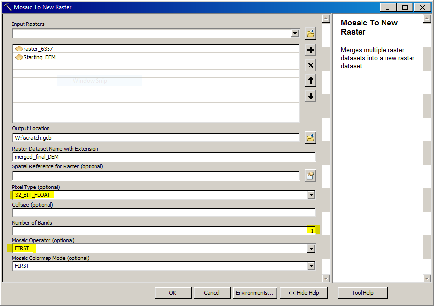
Be sure to pick the right pixel type - the same as the DEM you started with. Also be sure to add the 6357 foot raster first and then select FIRST as your mosaic operator.
Micah
- Mark as New
- Bookmark
- Subscribe
- Mute
- Subscribe to RSS Feed
- Permalink
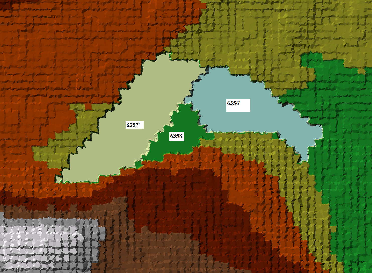
With the exception of the Mosaic to New Raster tool, it worked beautifully. I used the Mosaic tool, which pasted the clipped rasters onto the original raster. Rendered via TIN, you can see the three different elevations I depressed.
Thanks for the support fellow GIS gurus!