- Home
- :
- All Communities
- :
- Products
- :
- ArcGIS Spatial Analyst
- :
- ArcGIS Spatial Analyst Questions
- :
- IDW interpolation stopping at edge of point shapef...
- Subscribe to RSS Feed
- Mark Topic as New
- Mark Topic as Read
- Float this Topic for Current User
- Bookmark
- Subscribe
- Mute
- Printer Friendly Page
IDW interpolation stopping at edge of point shapefile
- Mark as New
- Bookmark
- Subscribe
- Mute
- Subscribe to RSS Feed
- Permalink
Hi,
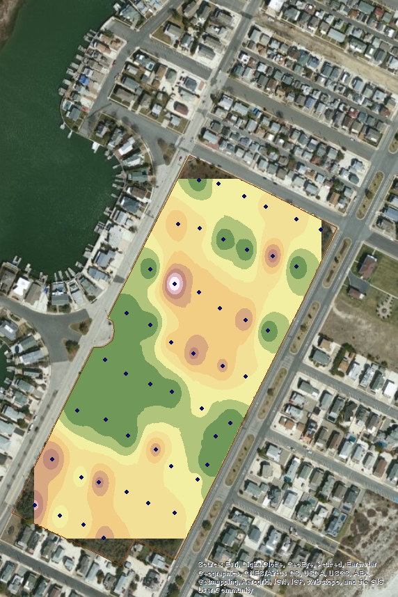
I'm fairly new to ArcGIS and I have never used the interpolation tools before this project. I am generating an interpolated surface to show vine impacts on trees within a nature preserve using data collected in the field. When using IDW, the interpolated surface stops at the furthest points in my shapefile, and does not fill the entire preserve, leaving the corners empty. I can clip the surface to the boundary but the corners of the preserve are still not included in the interpolated surface. I thought perhaps this was the way this tool is meant to function but I did some reading and found maps where the surface extends past the points, so I figure there must be some way to do this with my data as well. My question is, how do I generate an interpolated surface that covers the entirety of my study area? I've posted a jpeg of my current map below. Any help would be greatly appreciated!
Solved! Go to Solution.
Accepted Solutions
- Mark as New
- Bookmark
- Subscribe
- Mute
- Subscribe to RSS Feed
- Permalink
Lisa
Take a look at the Output Extent Environmental setting for the IDW tool...try using your preserve area to specify the Output Extent. It usually works the other direction where you have an output larger than the Output Extent but I think it is worth a shot.
- Mark as New
- Bookmark
- Subscribe
- Mute
- Subscribe to RSS Feed
- Permalink
Thanks Kyle, that worked!
- Mark as New
- Bookmark
- Subscribe
- Mute
- Subscribe to RSS Feed
- Permalink
Please be aware that setting the output extent to the desired area, this will generate values, but the IDW tool is an interpolation tool and extrapolated values (towards to edges) will probably lack precision. Take this into account when interpreting the results.