- Home
- :
- All Communities
- :
- Products
- :
- ArcGIS Spatial Analyst
- :
- ArcGIS Spatial Analyst Questions
- :
- Focal statistics problem values
- Subscribe to RSS Feed
- Mark Topic as New
- Mark Topic as Read
- Float this Topic for Current User
- Bookmark
- Subscribe
- Mute
- Printer Friendly Page
Focal statistics problem values
- Mark as New
- Bookmark
- Subscribe
- Mute
- Subscribe to RSS Feed
- Permalink
Hi,
I am using ArcGIS 10.1 and I am working with the Focal Statistics tool in order to get a smoother surface (I set "neighborhood rectangle 3x3 cell units" and as statistics type "mean"). The obtained result it looks like not so fine since the focal st. values seem increased respect to the input raster (see figures), but I don't understand the reason. The doubt arose making some comparison with other results in which the focal st. raster values are smaller than the input raster.
Could someone help me?
Thank you
- Mark as New
- Bookmark
- Subscribe
- Mute
- Subscribe to RSS Feed
- Permalink
Time to set the raster nodata is set so it doesn't foul up the focal stats in the areas where nodata borders data
- Mark as New
- Bookmark
- Subscribe
- Mute
- Subscribe to RSS Feed
- Permalink
Dan, I agree. Typically seeing zero (0) data is a red flag something is up unless expected.
- Mark as New
- Bookmark
- Subscribe
- Mute
- Subscribe to RSS Feed
- Permalink
Hi Roberto.
I'm sorry you're having some difficulty. Let's see if we can help get this sorted out.
First off, I notice the your input raster is identified as a 64-bit double-precision TIFF. Is this intentional? I don't often come across this particular type of Tiff data. If you use the Copy Raster GP tool to make a new version of the data with the Pixel Type set to a regular 32-bit float, does the resulting raster have the same outcome when used in the Focal Statistics tool?
If you convert your input raster to an Esri GRID format raster and use that as input, does the problem recur?
I did some testing with some local data that I mapped to a value range similar to what you report, but could not produce any unexpected results. Would it be possible to provide a copy of your data to test with? If you could prepare a smaller section of it that still demonstrates the problem, then it would facilitate the investigation.
Thanks,
Juan
- Mark as New
- Bookmark
- Subscribe
- Mute
- Subscribe to RSS Feed
- Permalink
thank you for your suggestion, I uploaded the sample tiff and a csv sample tile in order to have an idea on my data. The tiff is originated from the csv in CloudCompare software.
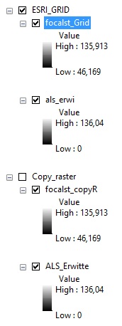
Moreover, I tried the tools that you suggested but the result is the same (see fig.)
- Mark as New
- Bookmark
- Subscribe
- Mute
- Subscribe to RSS Feed
- Permalink
Hi Roberto.
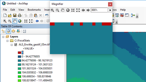
As others had suggested, the issue does seem to be a result of having cells with a value of 0 (instead of NoData) present in the input.
Highlighted below is a section of the input demonstrating some of those cells:
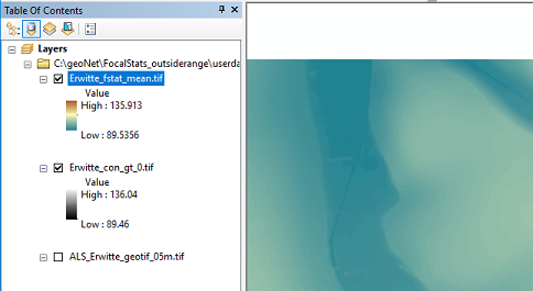
If you were to perform a Con operation on the input to convert those 0 values to actual NoData:

The final result should be more what you were expecting:
Hope this helps!
Cheers,
Juan
Spatial Analyst team
Esri, Inc
- « Previous
-
- 1
- 2
- Next »
- « Previous
-
- 1
- 2
- Next »