- Home
- :
- All Communities
- :
- Products
- :
- ArcGIS Spatial Analyst
- :
- ArcGIS Spatial Analyst Questions
- :
- Detecting avalanche debris based on their shape (E...
- Subscribe to RSS Feed
- Mark Topic as New
- Mark Topic as Read
- Float this Topic for Current User
- Bookmark
- Subscribe
- Mute
- Printer Friendly Page
Detecting avalanche debris based on their shape (Edit: +volume calculation)
- Mark as New
- Bookmark
- Subscribe
- Mute
- Subscribe to RSS Feed
- Permalink
So, here's what I'm trying to do: I want to detect avalanche debris of a known avalanche using Sentinel-2 optical imagery. I've calculated the Normalized Difference Snow Index and from there I've extracted all the values above 0.4 which gives me a raster file that contains all the snow for the scene. There, I can easily recognise the avalanche debris that lie below the snow line based on their distinctive elongated tongue shape.
Is it possible for ArcGIS (or any other application for that matter) to identify and extract these elongated tongue shapes? Basically what I want to end up with is a file that contains nothing but the avalanche debris without manually selecting them.
I'm rather new to ArcGis so I have no idea if this is super trivial or practically impossible.
Edit: I've attached a picture of the avalanche in question. Note that the blue raster is the approximated snow line (this was done with simple generalization tools, though I have yet to optimise this). The red raster is all the snow below this snow line from which I'd like ArcGIS to detect elongated shapes like the one in the center of this picture.
Edit2: Thank you Xander Bakker for your answer, that is very close to what I was looking for. I have a second quesion though: How would I go about calculating the volume of the debris? I have a 10m DEM and I know the extent of the debris, so it should be possible to calculate it. The problem that I have is that, as opposed to calculating the volume of a lake for example, I don't have a universal z value that would allow me to easily calculate the volume above or bellow said value. The debris start at a highter altitutde as opposed to where they end. I have a attached a picture of the avalanche in ArcScene. I hope I explained that clearly, I don't really know the correct terminology.
Solved! Go to Solution.
Accepted Solutions
- Mark as New
- Bookmark
- Subscribe
- Mute
- Subscribe to RSS Feed
- Permalink
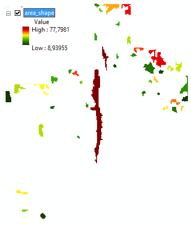
It would probably yield something like this:

Steps used:
- Region Group -> "region_group"
- Lookup using the field Count -> "lookup"
- Raster Calculator: Con(Raster(r"lookup")>= 25, Raster(r"region_group")) -> "region_group_large" (to filter out the small areas)
- Zonal Geometry, using the PERIMETER option -> "area_perimeter"
- Zonal Geometry, using the THICKNESS option -> "area_thickness"
- Raster Calculator: Raster(r"area_perimeter") / Raster(r"area_thickness") (the resulting raster with the relation between the perimeter and thickness)
- Mark as New
- Bookmark
- Subscribe
- Mute
- Subscribe to RSS Feed
- Permalink
probably not trivial, an image of a typical debris field might spark some comments
- Mark as New
- Bookmark
- Subscribe
- Mute
- Subscribe to RSS Feed
- Permalink
I have updated the post with a picture, I hope it helps.
- Mark as New
- Bookmark
- Subscribe
- Mute
- Subscribe to RSS Feed
- Permalink
I think you could... at least get close.
First of all you are interested in the areas of snow below the approximate snow line. These can be extracted using some raster math. The next thing would be to identify each separate connected area. This is done with the tool Region Group—Help | ArcGIS Desktop .
The next thing could be to identify some statistics for each area. You could for instance do some Zonal Statistics and determine the range of values in you DEM for each unique zone. See: Zonal Statistics as Table—Help | ArcGIS Desktop
Now when the range is large this does not necessarily mean that the zone contains avalanche debris. You could perhaps better use the Zonal Geometry tools and determine the fraction between the perimeter and the thickness of the area:
How Zonal Geometry works—Help | ArcGIS Desktop
The greater the resulting value the more probably will be that it is avalanche debris.
- Mark as New
- Bookmark
- Subscribe
- Mute
- Subscribe to RSS Feed
- Permalink
It would probably yield something like this:

Steps used:
- Region Group -> "region_group"
- Lookup using the field Count -> "lookup"
- Raster Calculator: Con(Raster(r"lookup")>= 25, Raster(r"region_group")) -> "region_group_large" (to filter out the small areas)
- Zonal Geometry, using the PERIMETER option -> "area_perimeter"
- Zonal Geometry, using the THICKNESS option -> "area_thickness"
- Raster Calculator: Raster(r"area_perimeter") / Raster(r"area_thickness") (the resulting raster with the relation between the perimeter and thickness)
- Mark as New
- Bookmark
- Subscribe
- Mute
- Subscribe to RSS Feed
- Permalink
Thank you, this was very helpfull! I have updated the post with a second question regarding volume calculations, maybe you can help me there as well.
- Mark as New
- Bookmark
- Subscribe
- Mute
- Subscribe to RSS Feed
- Permalink
How would I go about calculating the volume of the debris?
If you can create a surface of thickness, and a zone poly or raster coveriing your avalanche area, set the cell size to your thickness raster and run ZonalStatistics with SUM, multiply the result times the thickness raster cell size squared and you have your number. But -- be careful with units!
Hope that helps you!