Turn on suggestions
Auto-suggest helps you quickly narrow down your search results by suggesting possible matches as you type.
Cancel
- Home
- :
- All Communities
- :
- Products
- :
- ArcGIS Spatial Analyst
- :
- ArcGIS Spatial Analyst Questions
- :
- Automatically extract from raster using calculated...
Options
- Subscribe to RSS Feed
- Mark Topic as New
- Mark Topic as Read
- Float this Topic for Current User
- Bookmark
- Subscribe
- Mute
- Printer Friendly Page
Automatically extract from raster using calculated attributes
Subscribe
04-28-2014
07:03 PM
- Mark as New
- Bookmark
- Subscribe
- Mute
- Subscribe to RSS Feed
- Permalink
Hi there
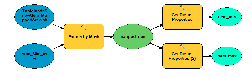
I am trying to extract attributes for the minimum and maximum elevation/slope/aspect/curvature etc. from a previously mapped area of vegetation in order to predict where the same veg community might exist elsewhere.
As shown in the screenshot, I've extracted the area by mask of the existing veg community and have calculated the min and max values automatically in model builder. But I can't get those properties to work with any of the tools that I would normally use to extract by attribute manually as they won't link in model builder.
Please help! I need to do this for many surfaces and many veg communities so doing it all manually isn't really a feasible option.
Thanks
Solved! Go to Solution.
1 Solution
Accepted Solutions
05-06-2014
06:32 AM
- Mark as New
- Bookmark
- Subscribe
- Mute
- Subscribe to RSS Feed
- Permalink
Hello Dan. Glad to be of help. I think we have similar interests. I'm a geospatial specialist for a conservation charity.
I also came across a new plug-in for QGIS which has a whole range of algoriths for distribution modelling
http://lifemapper.org/?page_id=18
I've havn't had chance to play around with them yet but they might be worth checking out.
I also came across a new plug-in for QGIS which has a whole range of algoriths for distribution modelling
http://lifemapper.org/?page_id=18
I've havn't had chance to play around with them yet but they might be worth checking out.
5 Replies
04-29-2014
11:57 AM
- Mark as New
- Bookmark
- Subscribe
- Mute
- Subscribe to RSS Feed
- Permalink
But I can't get those properties to work with any of the tools that I would normally use to extract by attribute manually as they won't link in model builder.
All model variables are a string representation, and the Calculate Value tool can be used to associate that string with a data type for tool parameter validation (so it will "connect" to a tool).
So, if you have a tool that has a SQL expression, the normal way to do this is to connect your model variable to the extract tool (say, Extract Raster By Attributes) and then enter the variable into the SQL expression like this:
VALUE < %dem_min%
or, you can use the Calculate Value tool to create the "where" string:
"VALUE < {0}".format("%dem_min%")
and set its output data type to SQL Expression - so you can link it to your extract tool as a parameter.
05-01-2014
07:20 PM
- Mark as New
- Bookmark
- Subscribe
- Mute
- Subscribe to RSS Feed
- Permalink
Thanks! That's a heap of help...
05-02-2014
06:07 AM
- Mark as New
- Bookmark
- Subscribe
- Mute
- Subscribe to RSS Feed
- Permalink
Have you heard of species distribution modelling? Have a look at Maxent. If you have point locations for your vegetation and a number of physical/environmental datasets you can create surface rasters indicating the probability of species occurance at any given point in your datasets
http://www.cs.princeton.edu/~schapire/maxent/
http://www.cs.princeton.edu/~schapire/maxent/
05-02-2014
10:05 PM
- Mark as New
- Bookmark
- Subscribe
- Mute
- Subscribe to RSS Feed
- Permalink
Thanks for that Mark. I'm an ecologist by training but have worked for a long time as a generalist spatial analyst, and haven't kept up with the ecology over the years. So as you can imagine having moved back into this area in a spatial capacity, I'm pretty excited about this! I'm going to be putting this to the project lead first thing Monday...
05-06-2014
06:32 AM
- Mark as New
- Bookmark
- Subscribe
- Mute
- Subscribe to RSS Feed
- Permalink
Hello Dan. Glad to be of help. I think we have similar interests. I'm a geospatial specialist for a conservation charity.
I also came across a new plug-in for QGIS which has a whole range of algoriths for distribution modelling
http://lifemapper.org/?page_id=18
I've havn't had chance to play around with them yet but they might be worth checking out.
I also came across a new plug-in for QGIS which has a whole range of algoriths for distribution modelling
http://lifemapper.org/?page_id=18
I've havn't had chance to play around with them yet but they might be worth checking out.