- Home
- :
- All Communities
- :
- Products
- :
- ArcGIS Spatial Analyst
- :
- ArcGIS Spatial Analyst Questions
- :
- Re: arcGIS error: 999999; error executing function
- Subscribe to RSS Feed
- Mark Topic as New
- Mark Topic as Read
- Float this Topic for Current User
- Bookmark
- Subscribe
- Mute
- Printer Friendly Page
arcGIS error: 999999; error executing function
- Mark as New
- Bookmark
- Subscribe
- Mute
- Subscribe to RSS Feed
- Permalink
I have tried running the flow direction / fill / flow accumulation tool several times for layer nav_dem_10m , but it always shows the following error. In fact, no tool is succeeding under hydrology tools (spatial analyst) except basin and shows almost same error for each tool I run.

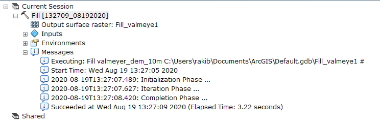
But whenever I run the layer valmeyer_dem_10m for flow direction or any tools under the hydrology toolset, every tool runs perfectly and obviously with no error. I have tried changing the raster format of layer nav_dem_10m into grid, .tiff, etc. But those also don't help. Flowing SS is for valmeyer_dem_10m
- Mark as New
- Bookmark
- Subscribe
- Mute
- Subscribe to RSS Feed
- Permalink
Fill (Spatial Analyst)—ArcGIS Pro | Documentation
Fill (Raster Analysis)—ArcGIS Pro | Documentation
The latter has the stipulation...
This raster analysis portal tool is available when you are signed in to an ArcGIS Enterprise
portal that has an ArcGIS Image Server
For the layer that fails, is the data local on your machine?
... sort of retired...
- Mark as New
- Bookmark
- Subscribe
- Mute
- Subscribe to RSS Feed
- Permalink
First of all, yes. All the data is on my local machine. I'm using ArcGIS 10.8. The reason I am frustrated is one layer is running fine other one isn't. P.S: I'm using an advance license.
- Mark as New
- Bookmark
- Subscribe
- Mute
- Subscribe to RSS Feed
- Permalink
Hello, I am getting the same error. Did you find a way to fix it? If so please explain ( screenshots are a plus!) Thank you so much!
- Mark as New
- Bookmark
- Subscribe
- Mute
- Subscribe to RSS Feed
- Permalink
I am facing the same problem any idea of how can get solve?
- Mark as New
- Bookmark
- Subscribe
- Mute
- Subscribe to RSS Feed
- Permalink
I am having the same problem and it keeps showing up like this. Does this has to do with ArcGIS 10.8?