Turn on suggestions
Auto-suggest helps you quickly narrow down your search results by suggesting possible matches as you type.
Cancel
- Home
- :
- All Communities
- :
- Products
- :
- ArcGIS Spatial Analyst
- :
- ArcGIS Spatial Analyst Questions
- :
- (again): "reclassify" introduces an error! why?
Options
- Subscribe to RSS Feed
- Mark Topic as New
- Mark Topic as Read
- Float this Topic for Current User
- Bookmark
- Subscribe
- Mute
- Printer Friendly Page
(again): "reclassify" introduces an error! why?
Subscribe
13195
13
08-24-2011 07:44 AM
08-24-2011
07:44 AM
- Mark as New
- Bookmark
- Subscribe
- Mute
- Subscribe to RSS Feed
- Permalink
(again): "reclassify" introduces an error! why?
please, see the attached image that shows my question
for my raster, i needed to reclassify the raster into 5 classes, but the reclassified raster gives an error!!!! why?
why this problem happens?
how to automatically avoid this problem?
regards
Jamal
please, see the attached image that shows my question
for my raster, i needed to reclassify the raster into 5 classes, but the reclassified raster gives an error!!!! why?
why this problem happens?
how to automatically avoid this problem?
regards
Jamal
----------------------------------------
Jamal Numan
Geomolg Geoportal for Spatial Information
Ramallah, West Bank, Palestine
Jamal Numan
Geomolg Geoportal for Spatial Information
Ramallah, West Bank, Palestine
13 Replies
by
Anonymous User
Not applicable
08-26-2011
07:15 AM
- Mark as New
- Bookmark
- Subscribe
- Mute
- Subscribe to RSS Feed
- Permalink
Original User: Tarun_Jaiswal
Hi Jamal,
Please convert your img file to tiff or grid format using Copy Raster tool.
http://help.arcgis.com/en/arcgisdesktop/10.0/help/index.html#//001700000094000000
and then reclassify the raster again.
Thanks.
Hi Jamal,
Please convert your img file to tiff or grid format using Copy Raster tool.
http://help.arcgis.com/en/arcgisdesktop/10.0/help/index.html#//001700000094000000
and then reclassify the raster again.
Thanks.
08-26-2011
09:31 AM
- Mark as New
- Bookmark
- Subscribe
- Mute
- Subscribe to RSS Feed
- Permalink
Hi Jamal,
Please convert your img file to tiff or grid format using Copy Raster tool.
http://help.arcgis.com/en/arcgisdesktop/10.0/help/index.html#//001700000094000000
and then reclassify the raster again.
Thanks.
Thank you for the answer Tarun_Jaiswal.
i tried it but didn't work. please, see the attached image
why this error happens?
regards
Jamal
----------------------------------------
Jamal Numan
Geomolg Geoportal for Spatial Information
Ramallah, West Bank, Palestine
Jamal Numan
Geomolg Geoportal for Spatial Information
Ramallah, West Bank, Palestine
by
Anonymous User
Not applicable
08-26-2011
11:55 AM
- Mark as New
- Bookmark
- Subscribe
- Mute
- Subscribe to RSS Feed
- Permalink
Original User: erictrice
Jamal,
In the Reclassify tool, click the button called "Precision" and send a screenshot of your settings. As the warning is indicating (not an error message) you may need to make adjustments to the precision, or maybe you just need to get it back to the defaults if you already made adjustments. I calculated an NDVI raster and reclassified it without any warnings. Only after fiddling with the settings and reducing the significant digits to only a couple was I able to repro the warning messages your are getting.
Regards,
Eric
08-26-2011
12:13 PM
- Mark as New
- Bookmark
- Subscribe
- Mute
- Subscribe to RSS Feed
- Permalink
Jamal,
In the Reclassify tool, click the button called "Precision" and send a screenshot of your settings. As the warning is indicating (not an error message) you may need to make adjustments to the precision, or maybe you just need to get it back to the defaults if you already made adjustments. I calculated an NDVI raster and reclassified it without any warnings. Only after fiddling with the settings and reducing the significant digits to only a couple was I able to repro the warning messages your are getting.
Regards,
Eric
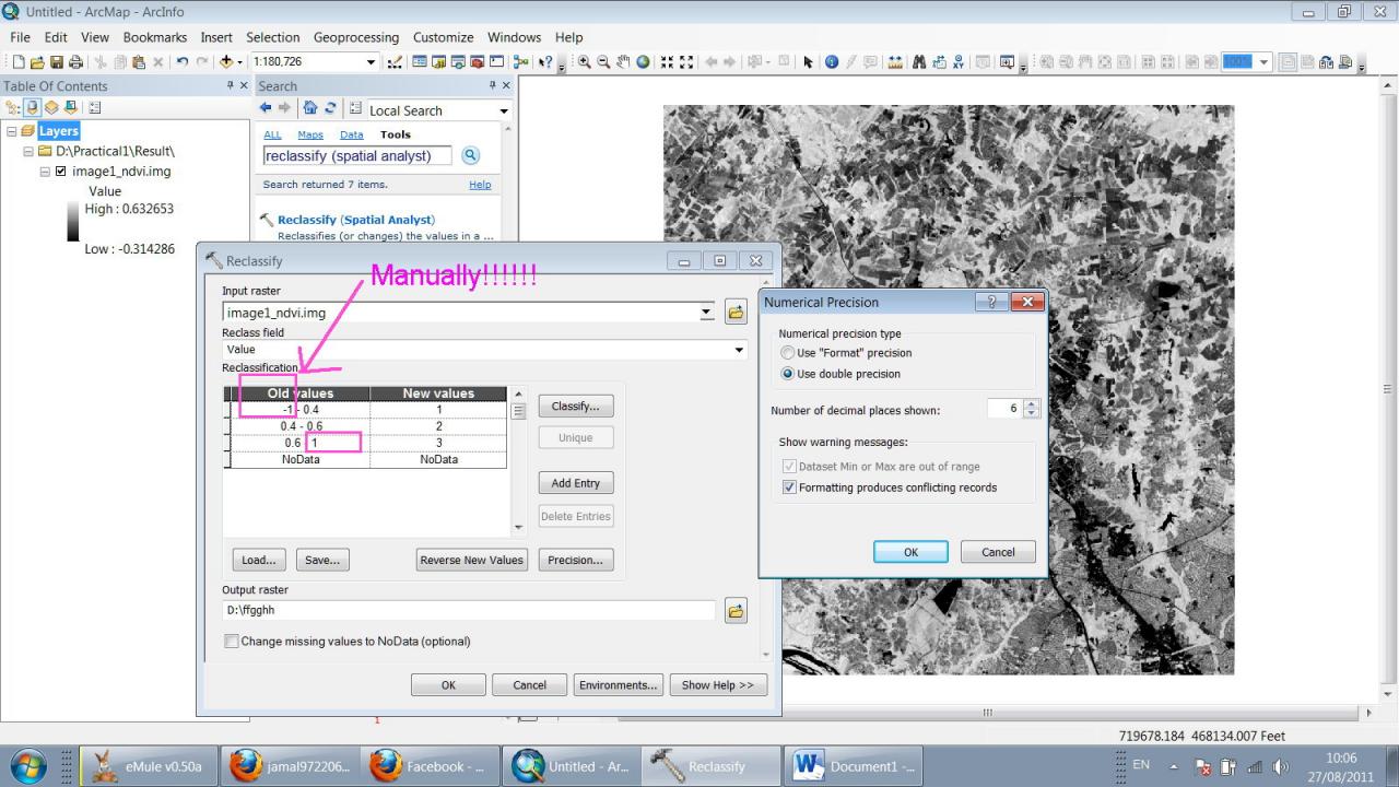
thank you for the help erictrice.
Attached is the screen shot for the precision.
the problem that the reclassification of "image1_ndvi.img" (attached in the previous post) generates this warning!!!!!
what's wrong with it?
what is the default?
regards
Jamal
----------------------------------------
Jamal Numan
Geomolg Geoportal for Spatial Information
Ramallah, West Bank, Palestine
Jamal Numan
Geomolg Geoportal for Spatial Information
Ramallah, West Bank, Palestine
by
Anonymous User
Not applicable
08-26-2011
03:30 PM
- Mark as New
- Bookmark
- Subscribe
- Mute
- Subscribe to RSS Feed
- Permalink
Original User: erictrice
Jamal,
Try increasing the significant digits to 9. If that doesn't work, check the option to use "Format" precision. For your min use -1.0 and for the max use 1.0. This worked for me. Optionally you could use the real min/max obtained from the layer properties > source tab > statistics section. Those are the real min/max values. The stats in the classification dialog are estimates.
Note, your screenshot is the default. Everytime you open the tool it should have those values. Any changes will only 'stick' if you make the changes, run the tool, then run the tool again from the Results window.
Regards,
Eric
08-27-2011
01:19 AM
- Mark as New
- Bookmark
- Subscribe
- Mute
- Subscribe to RSS Feed
- Permalink
Jamal,
Try increasing the significant digits to 9. If that doesn't work, check the option to use "Format" precision. For your min use -1.0 and for the max use 1.0. This worked for me. Optionally you could use the real min/max obtained from the layer properties > source tab > statistics section. Those are the real min/max values. The stats in the classification dialog are estimates.
Note, your screenshot is the default. Everytime you open the tool it should have those values. Any changes will only 'stick' if you make the changes, run the tool, then run the tool again from the Results window.
Regards,
Eric
thank you Eric.
sure, if i change MANUALLY the min and max, then it should work!!!!
my point is why ArcGIS is not able to get the true min and max automatically????!!!!! given that ArcGIS knows the actual min and max with right digital numbers!!!!!!
why we are involved in such problem as user?
my question is still valid:
how to classify AUTOMATICALLY this raster?
all the best
Jamal
----------------------------------------
Jamal Numan
Geomolg Geoportal for Spatial Information
Ramallah, West Bank, Palestine
Jamal Numan
Geomolg Geoportal for Spatial Information
Ramallah, West Bank, Palestine
by
Anonymous User
Not applicable
09-01-2011
10:08 AM
- Mark as New
- Bookmark
- Subscribe
- Mute
- Subscribe to RSS Feed
- Permalink
Original User: erictrice
Hi Jamal,
Sorry I haven't had a chance to get back to you sooner. I believe what you're experiencing is a data/version specific bug in the software. I would not expect any user to type the min/max (unless it's a workaround) to reclassify some data. I was only attempting, with that suggestion, to get you a reclassified raster that you could continue working with.
In an earlier post, I mentioned that I created a NDVI raster (from a single Landsat scene) using the Raster Calculator and was able to reclassify it without having to type the min/max or make any changes to the precision dialog. I actually had to intentionally mess it up to get the same warning as you. By default it was working as you would expect it to. The main difference between you and me though, is I was using 10.1 Beta version, and we have different (yet similar) data.
If you have the tutorial data installed you could use the same Landsat scene I used, to create your own NDVI raster and attempt to reclassify it to see if you get the error in 10.0. See attached for data location. If you can't repro the warning messages with the tutorial data, then it's probably specific to the raster values in your real dataset, and you might consider sending it to your local Esri distributor so they can forward it to us as part of a bug report.
Best Regards,
Eric
09-03-2011
08:15 AM
- Mark as New
- Bookmark
- Subscribe
- Mute
- Subscribe to RSS Feed
- Permalink
Hi Jamal,
Sorry I haven't had a chance to get back to you sooner. I believe what you're experiencing is a data/version specific bug in the software. I would not expect any user to type the min/max (unless it's a workaround) to reclassify some data. I was only attempting, with that suggestion, to get you a reclassified raster that you could continue working with.
In an earlier post, I mentioned that I created a NDVI raster (from a single Landsat scene) using the Raster Calculator and was able to reclassify it without having to type the min/max or make any changes to the precision dialog. I actually had to intentionally mess it up to get the same warning as you. By default it was working as you would expect it to. The main difference between you and me though, is I was using 10.1 Beta version, and we have different (yet similar) data.
If you have the tutorial data installed you could use the same Landsat scene I used, to create your own NDVI raster and attempt to reclassify it to see if you get the error in 10.0. See attached for data location. If you can't repro the warning messages with the tutorial data, then it's probably specific to the raster values in your real dataset, and you might consider sending it to your local Esri distributor so they can forward it to us as part of a bug report.
Best Regards,
Eric
Thank you Eric for the comprehensive answer.
The issue here is the reclassification not the NDVI! I expected that the ArcGIS can reclassify any raster AUTOMATICALLY!!! by the way, i got the NDVI (fro the image) from ERDAS 2011 then added this NDVI to ArcGIS for further analysis!
what about ArcGIS 10.1? when will it be available? and how come the ArcGIS 10.0 is full of bugs that much even with the very basic issues?
very much appreciated
regards
Jamal
----------------------------------------
Jamal Numan
Geomolg Geoportal for Spatial Information
Ramallah, West Bank, Palestine
Jamal Numan
Geomolg Geoportal for Spatial Information
Ramallah, West Bank, Palestine
by
Anonymous User
Not applicable
09-06-2011
02:28 PM
- Mark as New
- Bookmark
- Subscribe
- Mute
- Subscribe to RSS Feed
- Permalink
Original User: pyadav1
Hi Jamal,
I agree that the reclassify tool should automatically read min/max. I tried to reproduce this issue with similar data in ArcGIS 10 SP 2; however, I have not been able to reproduce the behavior you are experiencing. It could be possible that this behavior is either a data or a computer specific issue. Could you please try to see if you can reproduce this behavior with other rasters and/or on other computers?
ArcGIS 10.1 is scheduled to be released in the first quarter of 2012. ArcGIS 10.1 Beta 1 is currently available. Domestic (USA) users need to be current on maintenance and approved by the maintenance contact for their organization to participate. International users need to be nominated by their distributor.
We greatly appreciate our users�?? feedbacks and try our best to fix issues that we are aware of or our customers brought to us. We are sorry that you encounter issues in ArcGIS 10 and we will be glad to work with you to identify those issues and fix them in next service pack/release. You could contact Esri Support Services (in your case, I guess Esri UK) to report bugs.
Thank you for your feedback.
Best regards,
Pavan
Thank you Eric for the comprehensive answer.
The issue here is the reclassification not the NDVI! I expected that the ArcGIS can reclassify any raster AUTOMATICALLY!!! by the way, i got the NDVI (fro the image) from ERDAS 2011 then added this NDVI to ArcGIS for further analysis!
what about ArcGIS 10.1? when will it be available? and how come the ArcGIS 10.0 is full of bugs that much even with the very basic issues?
very much appreciated
regards
Jamal
Hi Jamal,
I agree that the reclassify tool should automatically read min/max. I tried to reproduce this issue with similar data in ArcGIS 10 SP 2; however, I have not been able to reproduce the behavior you are experiencing. It could be possible that this behavior is either a data or a computer specific issue. Could you please try to see if you can reproduce this behavior with other rasters and/or on other computers?
ArcGIS 10.1 is scheduled to be released in the first quarter of 2012. ArcGIS 10.1 Beta 1 is currently available. Domestic (USA) users need to be current on maintenance and approved by the maintenance contact for their organization to participate. International users need to be nominated by their distributor.
We greatly appreciate our users�?? feedbacks and try our best to fix issues that we are aware of or our customers brought to us. We are sorry that you encounter issues in ArcGIS 10 and we will be glad to work with you to identify those issues and fix them in next service pack/release. You could contact Esri Support Services (in your case, I guess Esri UK) to report bugs.
Thank you for your feedback.
Best regards,
Pavan