- Home
- :
- All Communities
- :
- Products
- :
- ArcGIS Spatial Analyst
- :
- ArcGIS Spatial Analyst Questions
- :
- Re: Adding .asc raster files to a map
- Subscribe to RSS Feed
- Mark Topic as New
- Mark Topic as Read
- Float this Topic for Current User
- Bookmark
- Subscribe
- Mute
- Printer Friendly Page
Adding .asc raster files to a map
- Mark as New
- Bookmark
- Subscribe
- Mute
- Subscribe to RSS Feed
- Permalink
Hi,
I'm using .asc raster files for the first time and after trying a bunch of things, I have no clue how to get that into my map.
I have a shapefile of Oahu called "Coastline" (polygon file of Oahu with GCS WGS83) and want to add a bathymetry layer (.asc file, UTM Projection Zone 4N, Ellipsoid WGS84) to the map. I don't seem to be adding the .asc file correctly.
After adding the Coastline file, I run Arc Toolbox > ASCII to Raster on the .asc file to add bathymetry. Both the coastline and the bathymetry images disappear. When I click "Full Extent", I can locate the ASCII to Raster image (it's really tiny), zoom to it but the Coastline layer is gone. It's nowhere to be found in my data frame. I tried projecting the Coastline layer to UTM before converting ascii to raster on the .asc file but that didn't work either.
Both layers are attached as zip files along with my ArcMap 10.3.1 screenshots. The kaneohe_bathy_4m.zip has a .jpg which shows the UTM projection information.
Can someone share the steps I should follow to use .asc files correctly with my Coastline layer?
Many thanks,
Frances
- Mark as New
- Bookmark
- Subscribe
- Mute
- Subscribe to RSS Feed
- Permalink
...did you notice in the help that you have to define the projection of the output?
- Mark as New
- Bookmark
- Subscribe
- Mute
- Subscribe to RSS Feed
- Permalink
Hi Steve,
Thanks for the reply. I hope you had a fun Christmas day.
I didn't notice to do a "Define Projection". Thanks for the note on that.
So I defined the projection of the ASCII to Raster layer to NAD_1983_HARN_StatePlane_Hawaii_3_FIPS_5103. Now when I do Full Extent, both datasets are visible in Data View, bathymetry at the very top of the screen and Oahu is at the very bottom of the screen. Since they're not aligning, I did "Project (Data Management)" on the Coastline layer to project it to StatePlane but the raster and the projected coastline layers still aren't aligning. The Projected Coastline layer has a GCS of "GCS_North_American_1983_HARN".
I looked at the Data Frame Properties and is it because the current coordinate system is "GCS_WGS_1984" while the Coastline is now GCS_North_American_1983_HARN? How do I get the layers to line up? Thanks!
- Mark as New
- Bookmark
- Subscribe
- Mute
- Subscribe to RSS Feed
- Permalink
I don't understand, you said the ascii file was in UTM and then you used Define Projection to set it to State Plane. If the asc file is in UTM you should use Define Projection to set it to UTM.
Note Define Projection does not change any projections, it just tells ArcGIS what the xy locations are.
A really good book that explains all this is Lining Up Data by Margaret Maher. I highly recommend this inexpensive book to my students, and even require it for my geodatabases class.
- Mark as New
- Bookmark
- Subscribe
- Mute
- Subscribe to RSS Feed
- Permalink
Hi Curtis,
Thanks for your response. Sorry, for being unclear. To recap: I have two files, a Coastline shapefile, and an ascii bathymetry file. I'd like to get the bathymetry file to line up with the Coastline shapefile.
- Coastline layer
- GCS - GCS_North_American_1983
- PCS - NAD_1983_UTM_Zone_4N
- Bathymetry layer - from metadata
- Grid_Coordinate_System: Grid_Coordinate_System_Name: Universal Transverse Mercator
Universal_Transverse_Mercator: UTM_Zone_Number: 4
Transverse_Mercator: Scale_Factor_at_Central_Meridian: 0.9996
Longitude_of_Central_Meridian: -159
Latitude_of_Projection_Origin: 0.0
False_Easting: 500000
False_Northing: 0.0
- Grid_Coordinate_System: Grid_Coordinate_System_Name: Universal Transverse Mercator
Following the suggestion to "Define Projection" for the bathymetry layer after doing "ASCII to Raster", I did "Define Projection" to UTM, selecting NAD_1983_UTM_Zone_4N to match the Coastline file (and also tried StatePlane just to try something). After defining the projection to UTM Zone 4N, the coastline layer doesn't line up to the ascii raster. When I click "Full Extent", the ascii raster is the only thing that appears (see attached). The coastline layer has completely disappeared even though the layer is checked in the Table of Contents.
Since the Coastline layer and the bathymetry layer have the same projection (NAD_1983_UTM_Zone_4N), shouldn't the layers line up?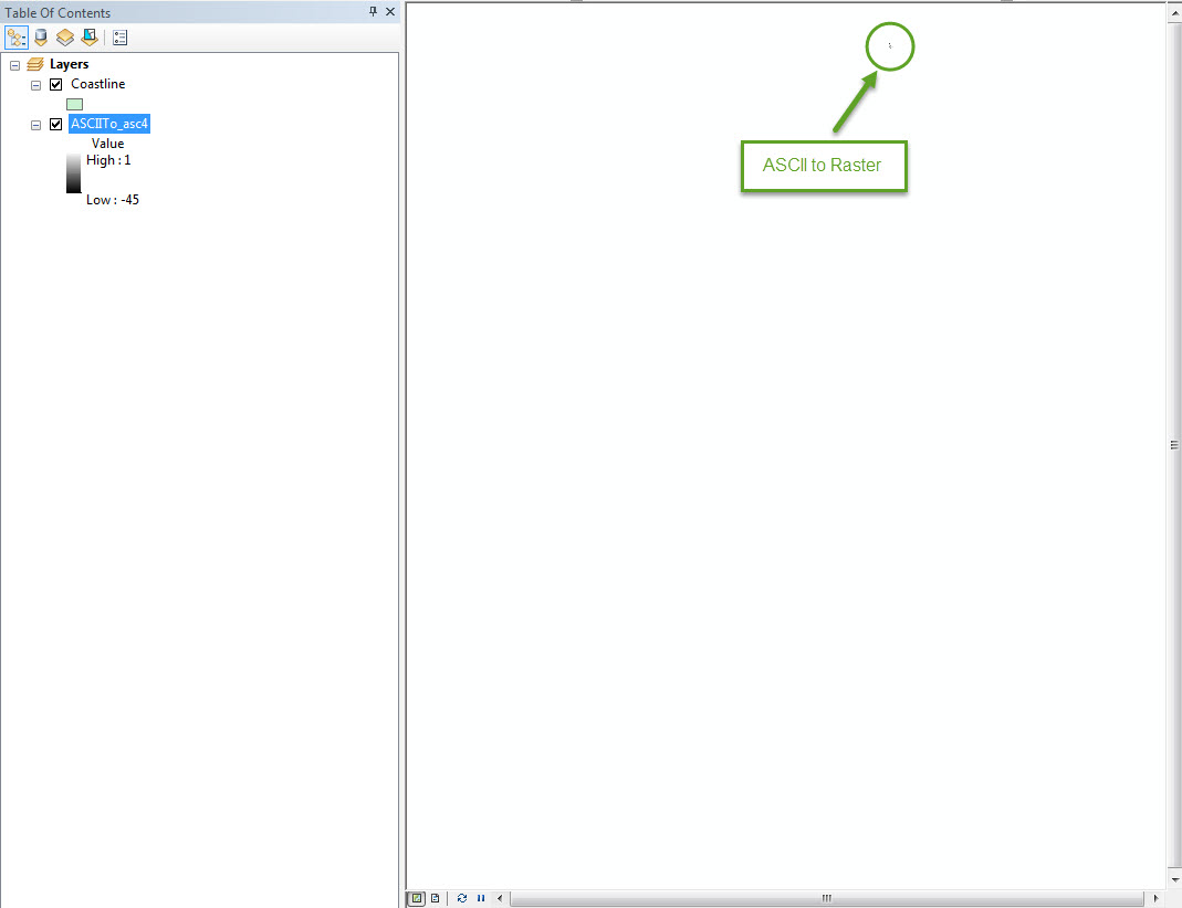
BTW, thanks for the book suggestion, Lining Up Data. I purchased it from Amazon and it should arrive January 2. In the meantime, any help would be greatly appreciated.
Many thanks,
Frances
- Mark as New
- Bookmark
- Subscribe
- Mute
- Subscribe to RSS Feed
- Permalink
Frances
For the bathy data, do you just have the .asc file or do you also have a .prj file?
Who created the .asc file and where does the metadata come from?
-Steve
- Mark as New
- Bookmark
- Subscribe
- Mute
- Subscribe to RSS Feed
- Permalink
Hi Steve,
Thanks for replying. The zip file for bathymetry has no .prj file but there is a .grd file. The metadata said to do "ASCII to Raster" in ArcMap, which is what I did on the .asc file. Since it didn't say anything about the .grd file, I didn't touch that file. Now that we're having this conversation, I think I'm supposed to do something with the .grd file...
I pulled the data from: O‘ahu: Bathymetry | Pacific Islands Benthic Habitat Mapping Center and I'm interested in the "Kaneohe Bay: 4 meter grid" files. All of the files were created by the Pacific Islands Benthic Habitat Mapping Center through University of Hawai'i.
Contents of the .zip file:
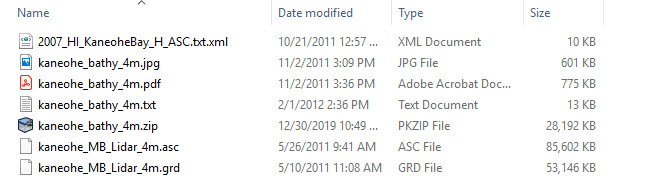
The .jpg and .pdf are the same, a document that has a image of the bay and depth by color, title, scale, etc.
I found this: Adding grid data to the map—Help | ArcGIS Desktop but it references a toolbar that I don't see, "Production Cartography". What should be my next move? Trying to load the .grd file? If yes, how would I do that in ArcMap 10.3 (Spatial Analyst is turned on)?
Many thanks,
Frances
- Mark as New
- Bookmark
- Subscribe
- Mute
- Subscribe to RSS Feed
- Permalink
I would suggest that you contact Pacific Islands Benthic Habitat Mapping Center through University of Hawai'i and find out what spatial reference you need to attach to the .asc file.
- Mark as New
- Bookmark
- Subscribe
- Mute
- Subscribe to RSS Feed
- Permalink
Hi Steve,
The metadata said the .asc file was in UTM Projection Zone 4N but doing "Define Projection" to that didn't work. I can't imagine what other spatial reference could be attached. Thanks for the suggestion. I emailed the group at UH last week and with the holidays, it's probably waiting in someone's inbox. If I get a reply and I'm able to get the two layers lined up, I'll post the solution to this thread.
Thank you for the assistance and happy new year!
\Frances
- Mark as New
- Bookmark
- Subscribe
- Mute
- Subscribe to RSS Feed
- Permalink
Hi Steve and Curtis,
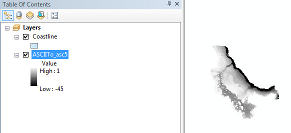
I was able to get a hold of ArcMap 10.6 and I followed the exact same steps ("ASCII to Raster" then "Define Projection"); both the Coastline and Bathymetry layers line up. I'm not sure why it wouldn't work on ArcMap 10.3 even with the usual tricks of clearing the cache and restarting the computer. I was able to finish my maps so if I encounter the same problem again on 10.3, I may just reinstall ArcMap. Thanks for all of your help!
\Frances