- Home
- :
- All Communities
- :
- User Groups
- :
- ArcGIS Server with JavaScript API
- :
- Questions
- :
- Re: How to set parameters within Local Government ...
- Subscribe to RSS Feed
- Mark Topic as New
- Mark Topic as Read
- Float this Topic for Current User
- Bookmark
- Subscribe
- Mute
- Printer Friendly Page
How to set parameters within Local Government Public Service Information .js for ArcGIS JavaScript API
- Mark as New
- Bookmark
- Subscribe
- Mute
- Subscribe to RSS Feed
- Permalink
I have successfully downloaded and installed the application on my IIS web server for development testing. I would like to configure it with my own parameters. I am having difficulty understanding how the JavaScript form function talks to the JSON file from the config.js and the servicerequest.js.
I have gone as far to rename my fields to REQUESTTYPE in my feature layer, but the request drop down still does not populate. Here is a sample of my js. I have tried
ServiceRequest: { Instructions: "<br/><b>Submit a Request for Service:</b> <br/> <br/>Please search for an address or click directly on the map to locate your request for service. Then, provide details about the request below and click Submit to initiate your request. You'll be provided a Request # that can be used to track the status of your request. If you find a request has already been submitted by another party, you can click on the existing request, provide additional comments and increase the importance of the request.<br /><br/><b>Please note:</b> Attachments can be used to submit a photo, video or other document related to a service request.<br/>",
        LayerInfo: {
            Key: "serviceRequest",
            LayerURL: "http://myHost/arcgis/rest/services/PublicInfoMapService/FeatureServer/0",
            OutFields: "*",
            RequestTypeFieldName: "REQUESTTYPE",
            //Set the attribute for requestID used for creating a new request


            CommentsLayerURL: "http://myHost/arcgis/rest/services/PublicInfoMapService/FeatureServer/1",
            CommentsOutFields: "*",
            //Set the primary key attribute for the comments
            CommentId: "${CommentsLayer}"
        },
My assumption is that this snippet works in coordination with the service request functions listed below. My JavaScript knowledge is somewhat limited, but this seems like it should be a fairly simple task, any assistance would be greatly appreciated.
//function to add service request layer on map
function AddServiceRequestLayerOnMap() {
    var serviceRequestLayer = new esri.layers.FeatureLayer(serviceRequestLayerInfo.LayerURL, {
        mode: esri.layers.FeatureLayer.MODE_SNAPSHOT,
        outFields: [serviceRequestLayerInfo.OutFields],
        id: serviceRequestLayerInfo.Key,
        displayOnPan: false,
        visible: false
    });
    map.addLayer(serviceRequestLayer);


    if (defaultServiceTab == 1) {
        ShowLoadingMessage("Loading...");
    }
    var serviceRequestLayerHandle = dojo.connect(serviceRequestLayer, "onUpdateEnd", function (features) {
        AddServiceLegendItem(this);
        PopulateRequestTypes(serviceRequestLayer.fields);
        HideLoadingMessage();
    });


    dojo.connect(serviceRequestLayer, "onClick", function (evt) {
        if (singleClickFlag) {
            ShowServiceRequestDetails(evt.mapPoint, evt.graphic.attributes);
            singleClickFlag = false;
        }
        setTimeout(function () {
            singleClickFlag = true;
        }, 1000);
        //For cancelling event propagation
        evt = (evt) ? evt : event;
        evt.cancelBubble = true;
        if (evt.stopPropagation) {
            evt.stopPropagation();
        }
    });


    dojo.connect(serviceRequestLayer, "onMouseOver", function (evt) {
        map.setMapCursor('pointer');
    });


    dojo.connect(serviceRequestLayer, "onMouseOut", function (evt) {
        map.setMapCursor('crosshair');
    });


    var serviceRequestCommentLayer = new esri.layers.FeatureLayer(serviceRequestLayerInfo.CommentsLayerURL, {
        mode: esri.layers.FeatureLayer.MODE_SELECTION,
        outFields: [serviceRequestLayerInfo.CommentsOutFields],
        id: serviceRequestLayerInfo.Key + "Comments"
    });
    map.addLayer(serviceRequestCommentLayer);
}


//function to showinfowindow
function ShowServiceRequestDetails(mapPoint, attributes) {
    infoWindowDescriptionFields = [];
    selectedServiceStatus = attributes.STATUS;
    if (!attributes.REQUESTID || attributes.REQUESTID == showNullValueAs) {
        attributes.REQUESTID = showNullValueAs;
        map.infoWindow.setTitle("<span id='spanInfoTitle' title='" + attributes.REQUESTID + "' style='color:white; font-size:11px; font-weight:bolder; font-family:Verdana;'> Service Request ID:" + attributes.REQUESTID + "</span>");
    }
    else {
        map.infoWindow.setTitle("<span id='spanInfoTitle' title='" + attributes.REQUESTID + "' style='color:white; font-size:11px; font-weight:bolder; font-family:Verdana;'> Service Request ID: #" + attributes.REQUESTID + "</span>");
    }
    var mainTabContainer = CreateServiceRequestTabContainer(attributes);
    map.infoWindow.setContent(mainTabContainer.domNode);
    mainTabContainer.resize();
    var windowPoint = map.toScreen(mapPoint);
    map.infoWindow.resize(310, 200);
    setTimeout(function () {
        map.infoWindow.show(mapPoint, GetInfoWindowAnchor(windowPoint, 310));
        mainTabContainer.resize();
        for (var index in infoWindowDescriptionFields) {
            CreateScrollbar(dojo.byId(index), dojo.byId(infoWindowDescriptionFields[index]));
        }


        CreateScrollbar(dojo.byId('divDetailsContainer'), dojo.byId('divDetailsContent'));
    }, 1000);


    FetchRequestComments(attributes.REQUESTID);
    FetchAttachmentDetails(attributes[map.getLayer(serviceRequestLayerInfo.Key).objectIdField]);
    RemoveChildren(dojo.byId("divAttachmentsData"));
    RemoveChildren(dojo.byId("divCommentsContent"));


    CreateRatingWidget(dojo.byId('commentRating'));
    ToggleCommentsView(false);
}


//function to fetch attachment details
function FetchAttachmentDetails(objectID) {
    map.getLayer(serviceRequestLayerInfo.Key).queryAttachmentInfos(objectID, function (files) {
        var fileTable = document.createElement("table");
        var fileTBody = document.createElement("tbody");
        fileTable.appendChild(fileTBody);


        for (var i = 0; i < files.length; i++) {
            if (files.contentType.indexOf("image") != 0) {
                fileTBody.appendChild(CreateData(files.name, files.url, files.size, files.contentType));
            }
        }


        for (var i = 0; i < files.length; i++) {
            if (files.contentType.indexOf("image") >= 0) {
                fileTBody.appendChild(CreateData(files.name, files.url, files.size, files.contentType));
            }
        }
        fileTable.appendChild(fileTBody);


        if (files.length == 0) {
            var trNoAttachments = document.createElement("tr");
            var tdNoAttachments = document.createElement("td");
            trNoAttachments.appendChild(tdNoAttachments);
            tdNoAttachments.innerHTML = "No attachments found.";
            fileTBody.appendChild(trNoAttachments);
        }
        dojo.byId("divAttachmentsData").appendChild(fileTable);


        if (file.length > 0) {
            CreateScrollbar(dojo.byId("divAttachments"), dojo.byId("divAttachmentsData"));
        }
    });
}
Solved! Go to Solution.
Accepted Solutions
- Mark as New
- Bookmark
- Subscribe
- Mute
- Subscribe to RSS Feed
- Permalink
Hello Geoffrey,
Thanks for contact with us. I think its better to share the solution about how to populate the drop down list about the Service Request Type here:
- The ServiceRequestType dropdown info get from the field name called “REQUESTTYPE” from the live feature service: (http://services.arcgis.com/b6gLrKHqgkQb393u/ArcGIS/rest/services/ServiceRequestTryItLive/FeatureServ...)
- Checked the LocalGovernment.gdb file downloaded from the local government template. Click the “CitizenService” feature dataset – “ServiceRequest” feature class – right click “ServiceRequest” – choose subTypes tab – click “Domains..” button
- On the config.js file, the RequestTypeFieldName point to: "REQUESTTYPE", all the dropdown values come from the code value of Domain in “ServiceRequestType”
- I attached a screenshot about the how to view the domain from the ArcMap. Technically, two things you should keep in mind:
1. Setup your own data follow this structure and the dropdown menu should populate correctly.
2. On the config.js file, call the right field name which content the “domain” of all the servicesRequestType
- Mark as New
- Bookmark
- Subscribe
- Mute
- Subscribe to RSS Feed
- Permalink
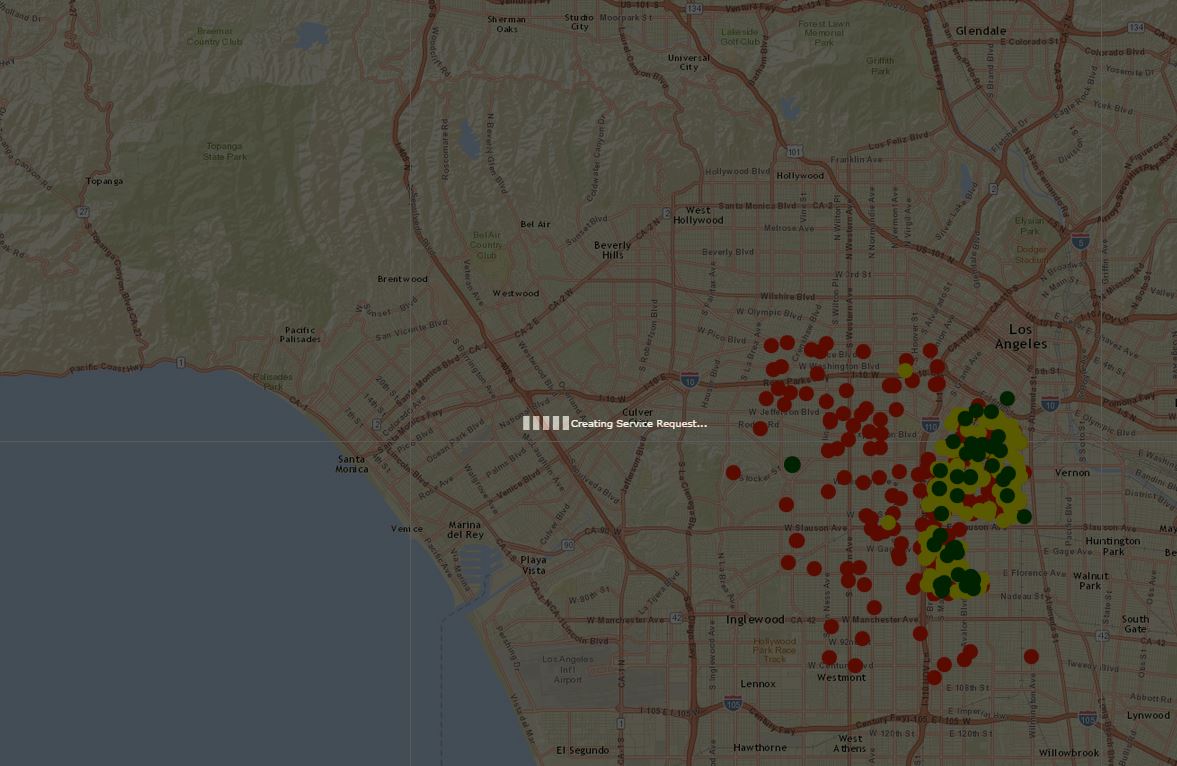
Hi Yue,
This solution works. We are now receiving the error below. The proxy.ashx is configured correctly, but when submitting an edit, the message "creating service request" remains on the map. There are no errors in the console or network. We are able to ping other addresses when switch the mustMatch parameter to false, and hit our own server when it is true.
EDIT: The ajax function to apply edits returns 200 OK, but this screen still appears, and the updated data does not appear in my database.