- Home
- :
- All Communities
- :
- Products
- :
- ArcGIS Production Mapping
- :
- ArcGIS Production Mapping Questions
- :
- Why do I get different hypsography results dependi...
- Subscribe to RSS Feed
- Mark Topic as New
- Mark Topic as Read
- Float this Topic for Current User
- Bookmark
- Subscribe
- Mute
- Printer Friendly Page
Why do I get different hypsography results depending on arcmap version?
- Mark as New
- Bookmark
- Subscribe
- Mute
- Subscribe to RSS Feed
- Permalink
Hi,
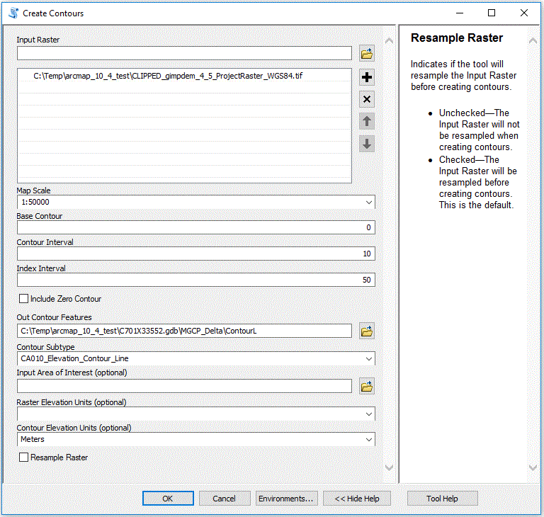
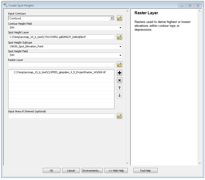
I recently ran the Create Contours and Create Spot Heights tools in ArcMap 10.6, but was surprised to see that no spot heights were created in a rural area.
After testing forth and back I ran the same tools on ArcMap 10.4, with the same data and setup.
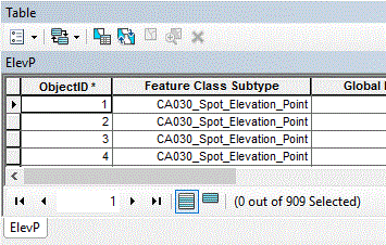
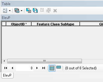
In ArcMap 10.4 909 spots and 1096 contours were created, while in 10.6 0 spots an 11 contours were created.
I have attached screenshots of the setup and results of the runs in 10.4 and 10.6. All the same extensions were checked out; 3D Analyst, Defense Mapping, Production Mapping and Spatial Analyst.
Are other people/companies experiencing the same thing (bug?), or has it something to do with other settings?
Best regards
Malik
Solved! Go to Solution.
Accepted Solutions
- Mark as New
- Bookmark
- Subscribe
- Mute
- Subscribe to RSS Feed
- Permalink
Hi Malik,
Thank you for responding so quickly as well. Thank you for attaching the CLIPPED_gimpdem_4_5_ProjectRaster_WGS84.tif and the screenshot of the Extensions dialog.
I can reproduce your issue. I think the cause of the issue is that your machine is using a comma (,) instead of a period (.) as a decimal delimiter. I will know more on Monday. I will try and provide a response by Tuesday morning.
Regards,
Dan
- Mark as New
- Bookmark
- Subscribe
- Mute
- Subscribe to RSS Feed
- Permalink
Hi Malik,
Thank you for the attachments.
You stated that you are running 10.6, but, I need you to answer the following:
1. What is the build number for ArcGIS Desktop? To get the build number, launch ArcMap and go to Help->About ArcMap... and dialog appears. Please provide the Version (i.e. 10.6.?)
2. What is the build number for Esri Defense Mapping? To get the build number, launch ArcMap and go to Customize->Extensions and the Extensions dialog is launched. On the Extensions dialog, highlight Defense Mapping with your cursor. What is the build number? Please see screenshot below for an example:

3. Can you please provide the CLIPPED_gimpdem_4_5_ProjectRaster_WGS84.tif?
Regards,
Dan
- Mark as New
- Bookmark
- Subscribe
- Mute
- Subscribe to RSS Feed
- Permalink
Hi Dan,
Thanks for the fast reply.
1.
The build number for Desktop is 10.6.0.8321
2.
The build number for Defense Mapping is 394.
3.
I have attached the data to the mail in a zip folder. It is GIMP, as is vaguely defined in the filename...
Best regards
Malik
Fra: Dan Hopkins <geonet@esri.com>
Sendt: Thursday, March 21, 2019 4:32 PM
Til: Malik Thrane <mathr@sdfe.dk>
Emne: Re: - Re: Why do I get different hypsography results depending on arcmap version?
GeoNet <https://community.esri.com/?et=watches.email.thread>
Re: Why do I get different hypsography results depending on arcmap version?
reply from Dan Hopkins<https://community.esri.com/people/dan_hopkins-esristaff?et=watches.email.thread> in Esri Production Mapping - View the full discussion<https://community.esri.com/message/839988-re-why-do-i-get-different-hypsography-results-depending-on-arcmap-version?commentID=839988&et=watches.email.thread#comment-839988>
- Mark as New
- Bookmark
- Subscribe
- Mute
- Subscribe to RSS Feed
- Permalink
Hi Malik,
Thank you for responding so quickly as well. Thank you for attaching the CLIPPED_gimpdem_4_5_ProjectRaster_WGS84.tif and the screenshot of the Extensions dialog.
I can reproduce your issue. I think the cause of the issue is that your machine is using a comma (,) instead of a period (.) as a decimal delimiter. I will know more on Monday. I will try and provide a response by Tuesday morning.
Regards,
Dan
- Mark as New
- Bookmark
- Subscribe
- Mute
- Subscribe to RSS Feed
- Permalink
Hi Dan,
Yes, it is the comma as decimal delimiter that made the difference. On my 10.6 pc the decimal delimiter was set to comma, while on the 10.4 it was set to period.
I tried to change the 10.6 pc to period as decimal delimiter, and then I got the same results as with 10.4, with 1096 contour lines and 909 elevation points.
Thanks for the help, don’t know why I didn’t think to check for that since I have run in to this before..
Best regards
Malik
Fra: Dan Hopkins <geonet@esri.com>
Sendt: Friday, March 22, 2019 11:08 PM
Til: Malik Thrane <mathr@sdfe.dk>
Emne: Re: - Re: Why do I get different hypsography results depending on arcmap version?
GeoNet <https://community.esri.com/?et=watches.email.thread>
Re: Why do I get different hypsography results depending on arcmap version?
reply from Dan Hopkins<https://community.esri.com/people/dan_hopkins-esristaff?et=watches.email.thread> in Esri Production Mapping - View the full discussion<https://community.esri.com/message/840412-re-why-do-i-get-different-hypsography-results-depending-on-arcmap-version?commentID=840412&et=watches.email.thread#comment-840412>
- Mark as New
- Bookmark
- Subscribe
- Mute
- Subscribe to RSS Feed
- Permalink
Hi Malik,
I have submitted the following BUG on your behalf:
BUG-000121164 - Create Contours script tool does not generate all contours when the Format on the Region properties dialog is set to a country that uses a comma for the decimal delimiter.
Regards,
Dan