- Home
- :
- All Communities
- :
- Developers
- :
- ArcGIS Pro SDK
- :
- ArcGIS Pro SDK Questions
- :
- Re: Creating feature layers from custom data
- Subscribe to RSS Feed
- Mark Topic as New
- Mark Topic as Read
- Float this Topic for Current User
- Bookmark
- Subscribe
- Mute
- Printer Friendly Page
Creating feature layers from custom data
- Mark as New
- Bookmark
- Subscribe
- Mute
- Subscribe to RSS Feed
- Permalink
I am sorry for the previous confusion, let me try to go into more details. I am trying to create a group layer and feature layers under the group layer. The source of the data is an outside source and the data is streamed into the plugin implementation through some TCP/IP based protocol. I have all the information (like XYZ) to create (for example) point features in a new, customized feature layer. When doing the same in ArcMap and in the old ESRi API we:
1. Created a new feature layer: IFeatureLayer newLayer = new FeatureLayerClass();
2. Created a new feature class and built up the field information IFeatureClass newClass = .... using esriGeometryType.esriGeometryPoint,
3. Set the feature class on the new layer. newLayer.FeatureClass = newClass; newLayer.Name = ...; newLayer.Visible = true;
4. Added it to the previously created group layer. groupLayer.Add(newLayer);
I am trying to replicate the same logic using the new ArcGIS Pro SDK and I'm having trouble getting the same result.
Zoltan
- Mark as New
- Bookmark
- Subscribe
- Mute
- Subscribe to RSS Feed
- Permalink
Hi Zoltan,
This workflow is now a bit more complicated because you have to use a GP Tool to create a new feature class, and then you can add that feature class as a layer to your group in your map's content. Below is a code snippet that will do this - I collected the code from various ArcGIS Pro SDK community samples. Just create a new project with a blank map, add a button with the code below and it should add a group and your new feature layer within that group. Since the GPTool also creates a new feature layer in your map you need to remove that feature layer since it's now in the new group. 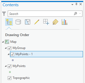
using System;
using System.Collections.Generic;
using System.Linq;
using System.Text;
using System.Threading.Tasks;
using ArcGIS.Core.Data;
using ArcGIS.Core.Geometry;
using ArcGIS.Desktop.Core;
using ArcGIS.Desktop.Core.Geoprocessing;
using ArcGIS.Desktop.Framework;
using ArcGIS.Desktop.Framework.Contracts;
using ArcGIS.Desktop.Framework.Dialogs;
using ArcGIS.Desktop.Framework.Threading.Tasks;
using ArcGIS.Desktop.Mapping;
namespace ProAppModule1
{
internal class Button1 : Button
{
protected override void OnClick()
{
MakeFeatureClassInAdd2Group("MyPoints", "MyGroup");
}
private async void MakeFeatureClassInAdd2Group (string fcName, string grpName)
{
Map activeMap = MapView.Active.Map;
// create the new Featureclass
var gpResult = await CreateLayer(fcName, "POINT");
if (gpResult.IsFailed)
{
MessageBox.Show($@"Error {gpResult.ErrorCode} in GP Tool: {gpResult.ErrorMessages}");
}
await QueuedTask.Run(() => {
// create the group layer
GroupLayer grpNew = LayerFactory.Instance.CreateGroupLayer(activeMap,
0, // add to the top ?
grpName);
// add the newly created feacture class as a layer to the group
var fcPath = System.IO.Path.Combine(Project.Current.DefaultGeodatabasePath, fcName);
LayerFactory.Instance.CreateFeatureLayer(
new Uri(fcPath),
grpNew,
layerName: $@"{fcName} - 1");
});
// TODO: delete the layer which was added by the GPTool
}
/// <summary>
/// Create a feature class in the default geodatabase of the project.
/// </summary>
/// <param name="featureclassName">Name of the feature class to be created.</param>
/// <param name="featureclassType">Type of feature class to be created. Options are:
/// <list type="bullet">
/// <item>POINT</item>
/// <item>MULTIPOINT</item>
/// <item>POLYLINE</item>
/// <item>POLYGON</item></list></param>
/// <returns>Result of GP operation</returns>
private async Task<IGPResult> CreateLayer(string featureclassName,
string featureclassType)
{
List<object> arguments = new List<object>
{
CoreModule.CurrentProject.DefaultGeodatabasePath, // use the default geodatabase
featureclassName, // name of the feature class
featureclassType, // type of geometry
"", // no template
"DISABLED", // no z values
"DISABLED" // no m values
};
await QueuedTask.Run(() =>
{
arguments.Add(SpatialReferenceBuilder.CreateSpatialReference(3857)); // Projected Coordinate System WGS 1984 Web Mercator Auxiliary Sphere
});
return await Geoprocessing.ExecuteToolAsync("CreateFeatureclass_management", Geoprocessing.MakeValueArray(arguments.ToArray()));
}
}
}
- Mark as New
- Bookmark
- Subscribe
- Mute
- Subscribe to RSS Feed
- Permalink
Wolf,
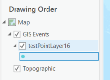
Thank you very much for the directions. Now I use the GeoProcessing API call to create the feature class and after locating it in the map's layer collection I can move it under the group layer I previously created (I will handle possible duplicates):
// Find the new layer in the root folder of the map.
Layer newLayer = activeMap.Layers.First((layer) => layer.Name == layerName);
// ... check for errors.
// Move the new layer to the group Layer.
await QueuedTask.Run(() => groupLayer.MoveLayer(newLayer, 0));
Now I have the feature class element under my group layer and it is exactly what I need at the moment.
Zoltan