- Home
- :
- All Communities
- :
- Products
- :
- ArcGIS Pro
- :
- ArcGIS Pro Questions
- :
- Windbreaks Model - Raster Layer?
- Subscribe to RSS Feed
- Mark Topic as New
- Mark Topic as Read
- Float this Topic for Current User
- Bookmark
- Subscribe
- Mute
- Printer Friendly Page
Windbreaks Model - Raster Layer?
- Mark as New
- Bookmark
- Subscribe
- Mute
- Subscribe to RSS Feed
- Permalink
Hi there. As part of a project, I am aiming to create a map layer showing ground wind speeds past a windbreak. I have a series of 1D equations that takes into account the upstream ground wind speed, wind direction, porosity, width and height of the windbreak, but am trying to figure out the best (and least time consuming) way of integrating this into ArcMap.
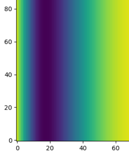
This is what the equation looks like when modelled as a raster in Python with the length on y axis and downstream direction on x axis. x = 0 is the position of the windbreak. Dark purple means a slower wind speed.
So far I have made a clipped map layer of a selection of windbreaks of polyline type that have a series of measured attributes as mentioned (porosity, width, height). The next step is to create an empty raster layer from which I can calculate the wind speed into a new field class.
Overall, I guess my question is: what would be the best method of inputting this equation into arcmap as mentioned that creates a raster layer that looks like the figure shown?
Any replies are much appreciated. Thanks!
- Mark as New
- Bookmark
- Subscribe
- Mute
- Subscribe to RSS Feed
- Permalink
doing the equation depends on what it is... your bigger problem would be to assign real-world coordinates to it if the equation doesn't explicitly include them. If it doesn't you would have to provide a mechanism to assign coordinates and any rotation of the raster that is derived.
Perhaps showing your equation, one could provide a solution using tools in the Spatial Analyst or via NumPy and python (which you can bring back in given the caveat above.)
... sort of retired...
