- Home
- :
- All Communities
- :
- Products
- :
- ArcGIS Pro
- :
- ArcGIS Pro Questions
- :
- Re: Why does ArcGIS Pro have to be so slow???
- Subscribe to RSS Feed
- Mark Topic as New
- Mark Topic as Read
- Float this Topic for Current User
- Bookmark
- Subscribe
- Mute
- Printer Friendly Page
Why does ArcGIS Pro have to be so slow???
- Mark as New
- Bookmark
- Subscribe
- Mute
- Subscribe to RSS Feed
- Permalink
- Report Inappropriate Content
Why is ArcGIS Pro so slow? To select assets, field calculate, display layers, change symbology... the easiest of tasks that are commonly utilized within ArcMap are a drag on the software.
When will ArcGIS Pro become faster than ArcMap? That will be the day it could replace it as the goto product for GIS professionals.
- Mark as New
- Bookmark
- Subscribe
- Mute
- Subscribe to RSS Feed
- Permalink
- Report Inappropriate Content
I wonder if the storage location can play a big part in this problem. I don't work with data on the local c-drive, but I have found file gdb data on a network drive to perform much better in Pro than Oracle based SDE data (enterprise gdb).
Kory - were you using local c-drive data in your testing?
- Mark as New
- Bookmark
- Subscribe
- Mute
- Subscribe to RSS Feed
- Permalink
- Report Inappropriate Content
Yes. Local data on C. Yes, "many factors at play" which is why we need to have more details:)
Rick Gonzalez we want to help, we just need some more info, and maybe data. Probably best to move it off this thread, so email me directly and we can circle back to close the loop here.
- Mark as New
- Bookmark
- Subscribe
- Mute
- Subscribe to RSS Feed
- Permalink
- Report Inappropriate Content
Kory, do you have setups that you could perform a 'task' on these various storage types vs ArcMap and ArcGIS Pro.
I keep seeing the non-locally stored data cropping up time and again. Is it the nature of the beast? network issues? a communications issue between software and the database?
I have trolled far and wide and never seen any thing that says …. when using X (storage type and location ) expect a Y% increase in processing time compared to using Z (storage type and location)
I know that the operation may have an influence, but you would expect to see some comparison. The one Dan posted from ESRI at least shows that at least 2 of the 4 have 'issues', but Dan's times are even worse than ESRI's
- Mark as New
- Bookmark
- Subscribe
- Mute
- Subscribe to RSS Feed
- Permalink
- Report Inappropriate Content
Kory,
Good morning! Thanks for reaching out! I am going to have my IT guys do some research and testing on this soon. If we can’t come up with a solution and will circle back to you.
I will let you know.
Thanks!
Rick Gonzalez
- Mark as New
- Bookmark
- Subscribe
- Mute
- Subscribe to RSS Feed
- Permalink
- Report Inappropriate Content
Kory,
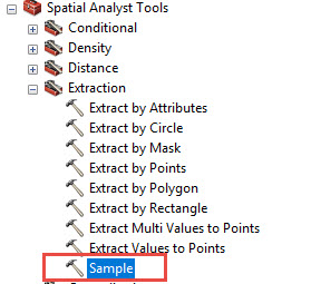
Trying to finally circle back to you on this. Sorry it's taken so long. I want to ask, did you you sample the arcgrid to a points fc? That's not really what I was doing. I was just simply outputting a dbf table with xyz values from the arcgrid using the Sample tool under Spatial Analyis > Extraction. Essentially this outputs the xyz values for each of the cells in an arcgrid.

- Mark as New
- Bookmark
- Subscribe
- Mute
- Subscribe to RSS Feed
- Permalink
- Report Inappropriate Content
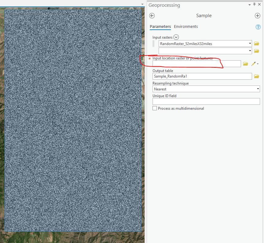
What are you using as the input location raster or point features?

- Mark as New
- Bookmark
- Subscribe
- Mute
- Subscribe to RSS Feed
- Permalink
- Report Inappropriate Content
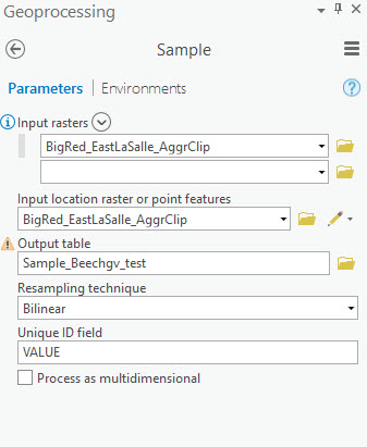
I am using the same raster as under Input rasters. In other words, the same raster I am sampling is also the input location raster. I use Bilinear resampling. Plus, on the Environments menu I set the extents to a rectangle shapefile that is about one fourth the area of the raster extents.

- Mark as New
- Bookmark
- Subscribe
- Mute
- Subscribe to RSS Feed
- Permalink
- Report Inappropriate Content
What raster format? Is it in a file geodatabase, .tif, etc.?
- Mark as New
- Bookmark
- Subscribe
- Mute
- Subscribe to RSS Feed
- Permalink
- Report Inappropriate Content
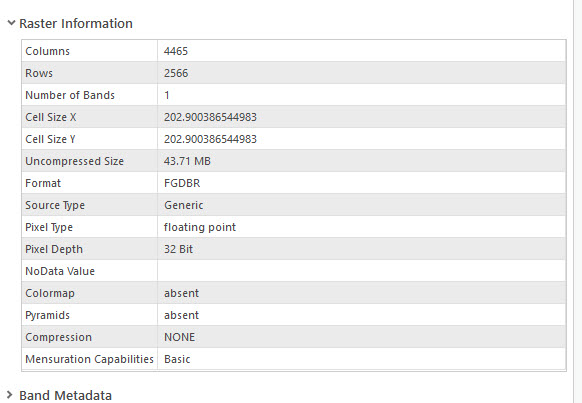
Kory, the Data Type is a File Geodatabase Raster stored on one of our network drives/servers.
Below is the Raster information

- Mark as New
- Bookmark
- Subscribe
- Mute
- Subscribe to RSS Feed
- Permalink
- Report Inappropriate Content
Rick - also, if you're willing/able to send data and steps directly to me at kkramer@esri.com we can probably take a quicker look. Email me and if we need to set up an ftp file transfer site we can.
Thanks