- Home
- :
- All Communities
- :
- Products
- :
- ArcGIS Pro
- :
- ArcGIS Pro Questions
- :
- Re: WGS 1984 (LL84) compaired to NAD 1983 StatePla...
- Subscribe to RSS Feed
- Mark Topic as New
- Mark Topic as Read
- Float this Topic for Current User
- Bookmark
- Subscribe
- Mute
- Printer Friendly Page
WGS 1984 (LL84) compaired to NAD 1983 StatePlane Projection off by a few meters
- Mark as New
- Bookmark
- Subscribe
- Mute
- Subscribe to RSS Feed
- Permalink
Hello,
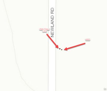
I have a issue where I have data generated in WGS 1984 and when we project the data into NAD 1984 the two points that should line up are now off by a few meters.
I found this thread on this issue.
Which essentially says the datum have drifted apart. Is this a known issue, and I need to store data in these two projection but display them on the same map. Is there a process to fix this?
Regards,
Jim
Solved! Go to Solution.
Accepted Solutions
- Mark as New
- Bookmark
- Subscribe
- Mute
- Subscribe to RSS Feed
- Permalink
Hey Dan,
Thanks for pointing me in the correct direction. The issue is the projection tool was using NAD_1983_To_WGS_1984_1 and I needed to use WGS_1984_(ITRF00)_To_NAD_1983 for a state plane projection.
Thanks
- Mark as New
- Bookmark
- Subscribe
- Mute
- Subscribe to RSS Feed
- Permalink
Hi Jim,
When two different layers are in two different project systems and you want to open in a single map frame. There is the only one solution to define the coordinate system in Map frame. Thanks
- Mark as New
- Bookmark
- Subscribe
- Mute
- Subscribe to RSS Feed
- Permalink
Hey DrVSSKiran,
Thanks for the reply. My map already has a defined projection and they don't line up. Usually you are correct the data should be projected on the fly and use the map projection, but that doesn't seem to be helping this time.
- Mark as New
- Bookmark
- Subscribe
- Mute
- Subscribe to RSS Feed
- Permalink
If your map is already defined a projection and still issue persists, then
we need to correct the data or else transfer both datasets into single
projection system.
Thanks
- Mark as New
- Bookmark
- Subscribe
- Mute
- Subscribe to RSS Feed
- Permalink
Thnaks for the help,
That still doesn't explain two data sets from the same source, one in WGS other same data set in NAD would not be able to be projected on the fly and line up.
- Mark as New
- Bookmark
- Subscribe
- Mute
- Subscribe to RSS Feed
- Permalink
How To: Determine which NAD_1983_To_WGS_1984 transformation to use (esri.com)
might be an appropriate read for datum issues
... sort of retired...
- Mark as New
- Bookmark
- Subscribe
- Mute
- Subscribe to RSS Feed
- Permalink
Hey Dan,
Thanks for pointing me in the correct direction. The issue is the projection tool was using NAD_1983_To_WGS_1984_1 and I needed to use WGS_1984_(ITRF00)_To_NAD_1983 for a state plane projection.
Thanks
- Mark as New
- Bookmark
- Subscribe
- Mute
- Subscribe to RSS Feed
- Permalink
No problem...
way too many NAD83's and WGS84's to start with
... sort of retired...

