- Home
- :
- All Communities
- :
- Products
- :
- ArcGIS Pro
- :
- ArcGIS Pro Questions
- :
- Re: Trying to get similar styles and symbols from ...
- Subscribe to RSS Feed
- Mark Topic as New
- Mark Topic as Read
- Float this Topic for Current User
- Bookmark
- Subscribe
- Mute
- Printer Friendly Page
Trying to get similar styles and symbols from Pro to Online, also what's the best/most seamless way to publish interactive map?
- Mark as New
- Bookmark
- Subscribe
- Mute
- Subscribe to RSS Feed
- Permalink
I have experience with ArcGIS Pro and Online but I am no super genius so please thoroughly explain any answers (step-by-step would be very helpful)! Thank you!
A few questions:
1.) I am attempting to publish a web map from Pro to Online and the symbols we use are very important to my work. Is there any way to import a symbol icon from Pro to Online? It is one symbol in particular.
2.) Once I upload a web map or web layers, the scale is off. When I zoom in on Online, my parcels and their labels shrink. I was able to adjust the other layers but some, like the parcel layer, seem to be stuck with this terrible scale. I've seen that you can pick a scale in Map Viewer Classic, I have tired and it didn't change anything, unless I did it incorrectly.
3.) Can anyone suggest a way or platform that I can publish a map that is almost perfect and matches my original map seamlessly, also relatively interactive? ArcGIS Online doesn't have the smoothness I'd hope for from an Esri publishing service. I really hoped the transition from Pro to Online would be more seamless but it isn't. My company needs to be able to access this information easily and have it look just like the map we already use.
All tricks and tips will be greatly appreciated, I am going to attach photos that also show what I am talking about. Thanks again!
Solved! Go to Solution.
Accepted Solutions
- Mark as New
- Bookmark
- Subscribe
- Mute
- Subscribe to RSS Feed
- Permalink
Hi there,
I’ve had some similar issues, hope this helps in some way!
1)
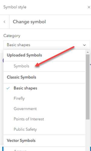
Is this for a point symbol? I haven't found a way to do this on AGOL like a layerfile so instead I upload a custom PNG. I use a free SVG editor to make the symbol and export the SVG to PNG-24 to use on AGOL. The SVG can be imported for use in Pro too.
In Map Viewer, the Symbol Styles window, is where you can drop your custom file.
Styles > Style
2 and 3)
It looks like you are using your own basemap layers in ArcGIS Pro, and Esri's basemaps in ArcGIS Online? Publishing your own base layers as vector tile layer and using it as the basemap in your webmap would be a good way to get around this and your labelling issue too. You can define scale dependencies so the labels make sense as you zoom in/out. Just make sure you set your scales to match the projection – WGS 1984 Web Mercator (auxiliary sphere).
This video is really helpful for setting this up https://www.youtube.com/watch?v=ZUSXmbUb9HU
All the best
- Mark as New
- Bookmark
- Subscribe
- Mute
- Subscribe to RSS Feed
- Permalink
For #1, you could also look into publishing your own Web Style from Pro. In that way, you can make your own symbol library from Pro available in ArcGIS Online as well. Here are som resources:
