- Home
- :
- All Communities
- :
- Products
- :
- ArcGIS Pro
- :
- ArcGIS Pro Questions
- :
- Split Polygon by Overlapping Feature in ArcGIS Pro
- Subscribe to RSS Feed
- Mark Topic as New
- Mark Topic as Read
- Float this Topic for Current User
- Bookmark
- Subscribe
- Mute
- Printer Friendly Page
Split Polygon by Overlapping Feature in ArcGIS Pro
- Mark as New
- Bookmark
- Subscribe
- Mute
- Subscribe to RSS Feed
- Permalink
In ArcMap, one can split a polygon using an overlapping feature (Advanced Editing--Split Polygons). Looking at the editing options in ArcGIS Pro, I cannot find this functionality (though there is a split tool, which would allow me to do it manually. In many instances, this is not a viable option for me).
Am I overlooking this functionality or does it currently not exist in Pro?
Thanks,
Todd
- Mark as New
- Bookmark
- Subscribe
- Mute
- Subscribe to RSS Feed
- Permalink
Hi Kirsten,
To get the similar functionality as Split Polygons in ArcMap - which avoids having to interactively select a target:
- Select the (input) lines or polys that you want to use to split the existing polygon (target)
- Open the Split tool > By Feature tab.
- The Input Features will show the selected line or poly that will be used to do the splitting.
- Switch to the Target Features tab.
- Click the "Select all intersecting features" button.
- Click Split.
You may also benefit by turning off the editability of layers that you do not want to select and subsequently split:
In the Contents pane, switch to the List By Editing tab and uncheck layers from there: Specify which layers can be edited—ArcGIS Pro | ArcGIS Desktop
Let me know if this helps,
Scott
- Mark as New
- Bookmark
- Subscribe
- Mute
- Subscribe to RSS Feed
- Permalink
I don't see a "Select all intersecting features" button under the Target Features tab, even when my target is the only feature crossing over my selected input features. Maybe it will appear when we move up to 2.4? Any way, I appreciate all the time you've looked at this for me. We had a one-off project & others already found a clunky work-around. Thanks, Scott!!
- Mark as New
- Bookmark
- Subscribe
- Mute
- Subscribe to RSS Feed
- Permalink
Our office is currently having the same issue. We edit parcels everyday and in Desktop, our workflow starts with editing parcel line work to using that line work to construct and split polygons to create parcel polys. I followed the steps listed above but I'm getting an error. We are trying to learn Pro so our office(s) can start transitioning but it's been very slow. This is tool is one that a lot of us use regularly and in bulk. Splitting polygons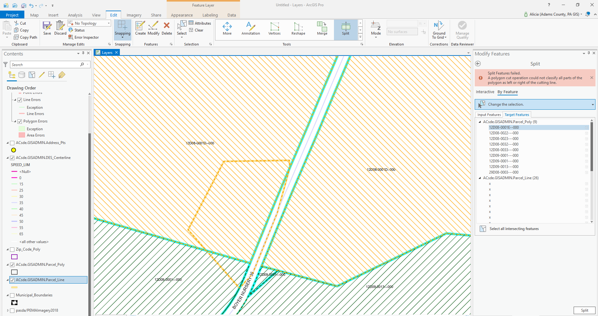 manually one at time is not ideal.
- Mark as New
- Bookmark
- Subscribe
- Mute
- Subscribe to RSS Feed
- Permalink
Hi Alicia,
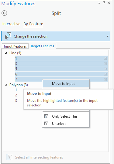
What are you using for the Input Features? Remember, Input Features are used to split the Target Features. From your screenshot, it looks like Parcel_Lines are being used as Target Features, but I'm assuming you want to move them to the Input. FYI - you can select multiple features by holding SHIFT+clicking in the list and then right-click and choose Move to Input or Target (depending on which tab you are in).
Thanks,
Scott
- Mark as New
- Bookmark
- Subscribe
- Mute
- Subscribe to RSS Feed
- Permalink
Thanks so much Scott! At first crack it did not work because I was getting this error: Split Features Failed. The operation was attempted on an empty geometry. The Split By Feature worked after I switched my coordinate system from WGS 84 Web Mercator to Alaska Albers Equal Area Conic in map properties: layers to match the coordinate system of the input and target features.
- Mark as New
- Bookmark
- Subscribe
- Mute
- Subscribe to RSS Feed
- Permalink
Is there a reliable equivalent to ArcMap's Splitting a polygon by an overlapping feature? I tried @Scott_Harris's suggestion from 08-20-2019, but to no avail. I have straightforward polyline street network that has been dissolved to a single feature and an overlapping polygon that I'd like to split into multiple features using the overlapping polyline. When attempting in Pro I receive this error "Split features failed. A polygon cut operation count not classify all parts of the polygon as left or right of the cutting line." I opened ArcMap and ran the Split Polygons tool in the Advanced Editing toolbar (using the same feature classes) and I got expected results in 10 seconds. The lack of parity between ArcMap and Pro continues to be infuriating as a long-time GIS user.
- Mark as New
- Bookmark
- Subscribe
- Mute
- Subscribe to RSS Feed
- Permalink
@AlexBrasch That sounds unexpected. The Split tool should work in the case you describe. Feel free to send me a direct message and we can look at it together. Or reach out to Esri Technical Support.
- Mark as New
- Bookmark
- Subscribe
- Mute
- Subscribe to RSS Feed
- Permalink
Thank you for reviewing @Scott_Harris! As you discovered, the data (Pro project and features classes) that I received from a city’s GIS team were mistakenly using different versions of the Massachusetts state plane coordinate system (features correctly in feet, and the map erroneously in meters). Once I switched the map from meters to feet, the Split tool produced the expected results. ArcMap worked straight-away because I opened a new map and added the feature classes, so the map adopted the correct coordinate system automatically.
- « Previous
-
- 1
- 2
- Next »
- « Previous
-
- 1
- 2
- Next »