- Home
- :
- All Communities
- :
- Products
- :
- ArcGIS Pro
- :
- ArcGIS Pro Questions
- :
- Ship detection with Arc GIS Pro - deep learning
- Subscribe to RSS Feed
- Mark Topic as New
- Mark Topic as Read
- Float this Topic for Current User
- Bookmark
- Subscribe
- Mute
- Printer Friendly Page
Ship detection with Arc GIS Pro - deep learning
- Mark as New
- Bookmark
- Subscribe
- Mute
- Subscribe to RSS Feed
- Permalink
Currently I try to develop and apply a deep learning model to detect vessels. I imported aerial imagery (3 bands, Color Infrared, 25 cm resolution, ECW files) and created manually about 200 training samples of ships. As software I used Arc GIS Pro in combination with Jupyter Notebook.
I exported the training samples to image chips and trained a model with 78% accuracy which looks promising.
As a last step I used the 'Detect Objects for Deep Learning' tool to apply my model. Results are shown in the image below:
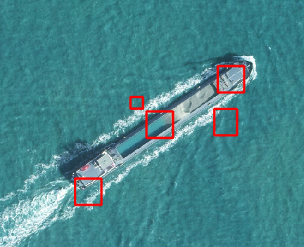
Did I something wrong that I get different predictions for actually one individual ship?
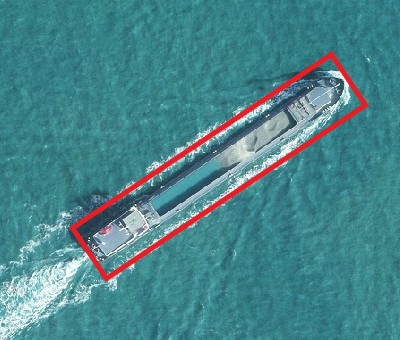
I hoped to get something like this:
Any suggestions how could I improve my results? Thanks in advance for your help!
- Mark as New
- Bookmark
- Subscribe
- Mute
- Subscribe to RSS Feed
- Permalink
Interesting. I would adjust the confidence parameter perhaps. That could help. Also how many ships did you have for training? Were they similar to those you wished to identify or more variable? Did the labeled objects you used for the training include the entire ship (as you showed in your preferred result)?
- Mark as New
- Bookmark
- Subscribe
- Mute
- Subscribe to RSS Feed
- Permalink
Hey, not sure if you are still working on this, but the issue above will be related to the chip size and stride of your training data. Your objects are relatively big and the default value '256' - from memory will not work for you.