- Home
- :
- All Communities
- :
- Products
- :
- ArcGIS Pro
- :
- ArcGIS Pro Questions
- :
- Re: Python routine to calculate MODIS NDVI anomaly
- Subscribe to RSS Feed
- Mark Topic as New
- Mark Topic as Read
- Float this Topic for Current User
- Bookmark
- Subscribe
- Mute
- Printer Friendly Page
Python routine to calculate MODIS NDVI anomaly
- Mark as New
- Bookmark
- Subscribe
- Mute
- Subscribe to RSS Feed
- Permalink
Python script to calculate NDVI anomalies
https://geonet.esri.com/people/xander_bakker
I´d like to automate all my workflow, from downloaded original raster datasets to anomaly calculator:
3 years data and folder structure can be downloaded here.
Question 1: What is the best option: to run separated scripts or create a unique code?
Question 2: How to translate the model builder to python script (Python script 2)?
Question 3: If the best option is to run separated, how to make it in a logical sequence (script 1 -> script 2 -> script 3)
Summary workflow:
- Select and download NDVI filtered raster datasets;
- Store downloaded original raster datasets at X:\Modis250\Originais\
- Organizing files and folders: (Python script 1)
- Rename original raster datasets (MODIS.ndvi.YYYYjjj.yL6000.BOKU.tif) to filename standard “ndvi_YYYY_dec_dd.tif”, where “YYYY” is the year, “jjj” is the Julian day and “dd” is the decade (ten days period).
- Transfer renamed files from X:\Modis250\Originais to X:\Modis250\NDVI10dias
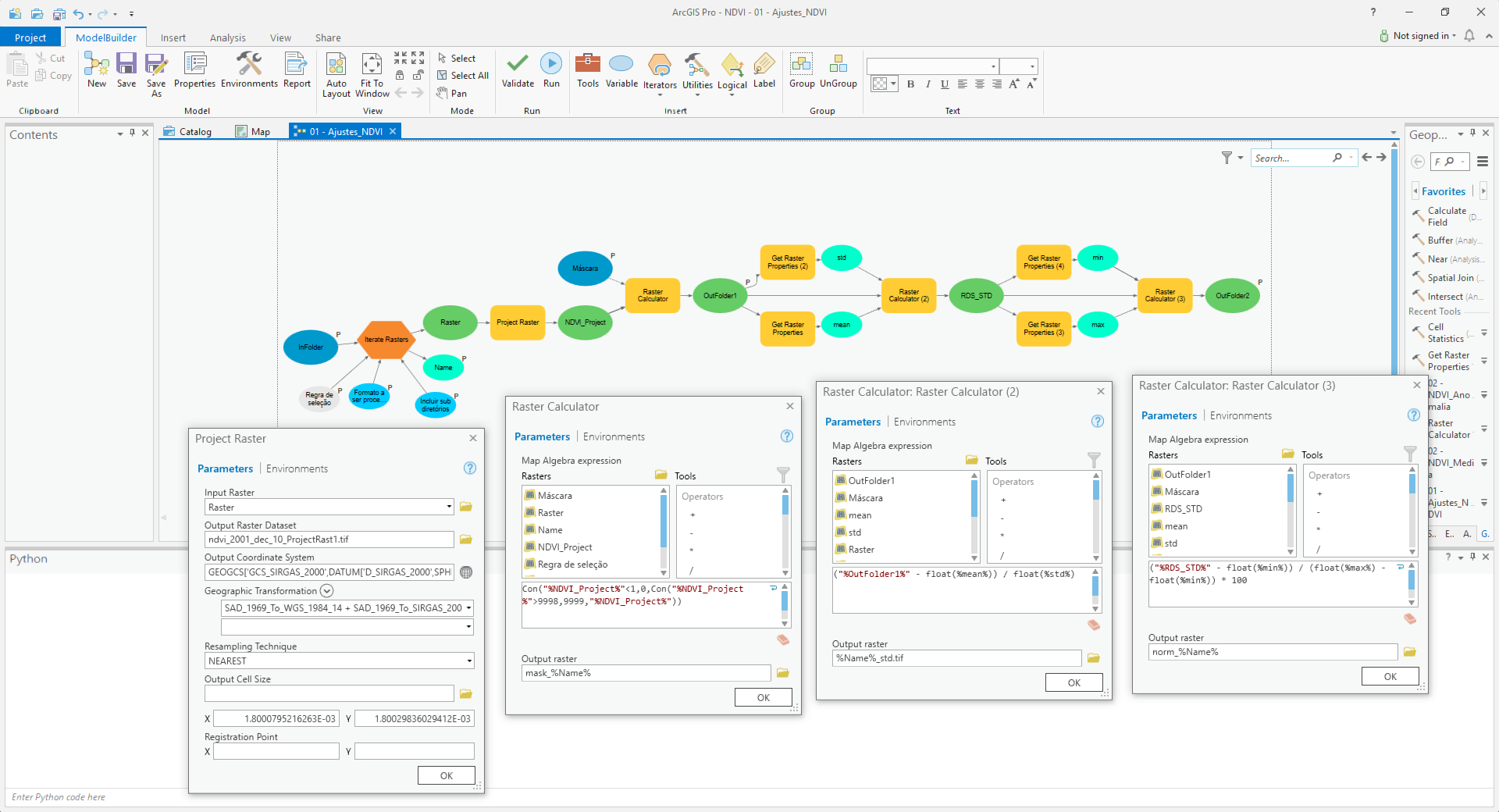
- Pre-processing raster datasets: (Python script 2)
- Project renamed raster datasets ("ndvi_YYYY_dec_dd.tif") from Lat/Lon WGS 1984 to Lat/Lon SIRGAS2000 using "SAD_1969_To_WGS_1984_14 + SAD_1969_To_SIRGAS_2000_1" geographic transformation.
- Overwrite spurious data values: NDVI = Con("%NDVI%"<1,0,Con("%NDVI%">9998,9999,"%NDVI%"))
- Standardize raster datasets: NDVI = (NDVI – Mean(NDVI))/Std(NDVI)
- Scale raster datasets to 0 – 100: NDVI = ((NDVI-Min(NDVI))/(Max(NDVI)-Min(NDVI)) * 100
- Mask standardized raster datasets by the area of interest (X:\Modis250\SRTM\mde_sc_90.tif) and output to X:\Modis250\NDVI_10dias_norm
- Processing data (Python script 3)
- Calculate NDVI mean for each decadal: mean_dec_dd.tif = MEAN (ndvi_YYY1_dec_dd.tif, ndvi_YYY2_dec_dd.tif, ndvi_YYY3_dec_dd.tif,…)
- Calculate NDVI anomaly for each year by decade: anom_yyyy_dec_dd.tif = ndvi_YYYY_dec_dd.tif - mean_dec_dd.tif
Python scripts 1 and 3 are working. The scrip 2 (Pre-processing) is a model in a toolbox.
Python script 1: written by myself, maybe need to be improved!
#Rename original files
import arcpy, datetime, glob, os
arcpy.env.overwriteOutput = True
arcpy.env.workspace=r'O:\Modis250\Originais'
infolder='O:\Modis250\Originals'
outfolder='O:\Modis250\NDVI_10dias'
list1=arcpy.ListRasters("*.tif")
list1.sort()
for raster in list1:
source_path = os.path.join(infolder, raster)
oldFilename=raster
dd = int(oldFilename[15:18])
if dd < 11: dd = 1
elif dd < 21: dd = 2
elif dd < 31: dd = 3
elif dd < 41: dd = 4
elif dd < 51: dd = 5
elif dd < 61: dd = 6
elif dd < 71: dd = 7
elif dd < 81: dd = 8
elif dd < 91: dd = 9
elif dd < 101: dd = 10
elif dd < 111: dd = 11
elif dd < 121: dd = 12
elif dd < 131: dd = 13
elif dd < 141: dd = 14
elif dd < 151: dd = 15
elif dd < 161: dd = 16
elif dd < 171: dd = 17
elif dd < 181: dd = 18
elif dd < 191: dd = 19
elif dd < 201: dd = 20
elif dd < 211: dd = 21
elif dd < 221: dd = 22
elif dd < 231: dd = 23
elif dd < 241: dd = 24
elif dd < 251: dd = 25
elif dd < 261: dd = 26
elif dd < 271: dd = 27
elif dd < 281: dd = 28
elif dd < 291: dd = 29
elif dd < 301: dd = 30
elif dd < 311: dd = 31
elif dd < 321: dd = 32
elif dd < 331: dd = 33
elif dd < 341: dd = 34
elif dd < 351: dd = 35
else: dd = 36
dd = str(dd)
newFilename="ndvi_" + oldFilename[11:15] + "_dec_" + dd + ".tif"
destination_path=os.path.join(outfolder, newFilename)
os.rename(source_path, destination_path)Model Builder -> Python script 2
Python script 3: Python script to calculate NDVI anomalies
def main():
import arcpy
import os
arcpy.env.overwriteOutput = True
# Check out SA license
arcpy.CheckOutExtension("spatial")
# settings
ws_norm = r'D:\Modis250\NDVI_10dias_norm'
ws_mean = r'D:\Modis250\NDVI_10dias_mean'
ws_anom = r'D:\Modis250\NDVI_10dias_anom'
# create a list of all raster in norm folder
arcpy.env.workspace = ws_norm
lst_ndvi_ras = arcpy.ListRasters()
lst_ndvi_ras.sort()
print ("lst_ndvi_ras: {}".format(lst_ndvi_ras))
# get list of years
decades = GetListOfDecades(lst_ndvi_ras)
decades.sort()
print ("decades: {}".format(decades))
# loop through each year
for decade in decades:
# Get rasters for given year
lst_ndvi_decade = GetListOfRasterForGivenDecade(lst_ndvi_ras, decade)
print("lst_ndvi_decade: {}".format(lst_ndvi_decade))
# calculate mean raster for decade
lst_ndvi_decade_paths = [os.path.join(ws_norm, r) for r in lst_ndvi_decade]
print("lst_ndvi_decade_paths: {}".format(lst_ndvi_decade_paths))
mean_ras = arcpy.sa.CellStatistics(lst_ndvi_decade_paths, "MEAN", "DATA")
# store mean ras for decade
# mean_dec_d_.tif
out_name_mean = "mean_dec_{}.tif".format(decade) ###
out_name_path_mean = os.path.join(ws_mean, out_name_mean)
print ("out_name_path_mean: {}".format(out_name_path_mean))
mean_ras.save(out_name_path_mean)
# loop through each raster in decade
for ndvi_ras in lst_ndvi_decade:
# calculate anom for each raster in decade
# anom_2002_dec_1.tif = norm_ndvi_2002_dec_1.tif - mean_dec_1_.tif;
print ("ndvi_ras: {}".format(ndvi_ras))
# minus_ras = arcpy.sa.Minus(ndvi_ras, out_name_path_mean)
out_name_path_norm = os.path.join(ws_norm, ndvi_ras)
minus_ras = arcpy.Raster(out_name_path_mean) - arcpy.Raster(out_name_path_norm)
# store anom raster
out_name_anom = ndvi_ras.replace("norm_ndvi", "anom")
out_name_path_anom = os.path.join(ws_anom, out_name_anom)
minus_ras.save(out_name_path_anom)
print ("out_name_path_anom: {}".format(out_name_path_anom))
# return SA license
arcpy.CheckInExtension("spatial")
def GetListOfDecades(lst):
# norm_ndvi_yyyy_dec_d.tif
lst1 = list(set([r.split("_")[4] for r in lst]))
return [r.split('.')[0] for r in lst1]
def GetListOfRasterForGivenDecade(lst, decade):
lst1 = []
search = "_{}.tif".format(decade)
for r in lst:
if search in r.lower():
lst1.append(r)
return lst1
if __name__ == '__main__':
main()Solved! Go to Solution.
- Mark as New
- Bookmark
- Subscribe
- Mute
- Subscribe to RSS Feed
- Permalink
I write a batch file to run the scripts sequentialy. Can I insert a last line to delete all files in Temp workspace after all?
Like:
@ECHO OFF
REM Runs NDVI anomaly scripts
ECHO Selecting decade and renaming original files to "ndvi_YYYY_dec_dd.tif" standard.
C:\Python27\ArcGIS10.5\Python.exe D:\Modis250\Python\Script1.py
ECHO NDVI files renamed, hit enter to pre-processing data.
PAUSE
ECHO Projecting, removing spurious data, standardizing and scaling ndvi decade files to 0-100.
C:\Python27\ArcGIS10.5\Python.exe D:\Modis250\Python\Script2.py
ECHO NDVI pre-processed, hit enter to calculate anomalies.
PAUSE
ECHO Calculating decade anomalies.
C:\Python27\ArcGIS10.5\Python.exe D:\Modis250\Python\Script3.py
del *.* D:\Temp
ECHO Done.
PAUSE- Mark as New
- Bookmark
- Subscribe
- Mute
- Subscribe to RSS Feed
- Permalink
I guess you could in case ArcGIS released any locks on the datasets...
- Mark as New
- Bookmark
- Subscribe
- Mute
- Subscribe to RSS Feed
- Permalink
Python routine to calculate MODIS NDVI anomaly:
modisndvi calculation ndvi
Summary workflow:
- Select and download NDVI filtered raster datasets;
- Store downloaded original raster datasets at X:\Modis250\Originais\
- Organizing files and folders: (Python script 1)
- Rename original raster datasets (MODIS.ndvi.YYYYjjj.yL6000.BOKU.tif) to filename standard “ndvi_YYYY_dec_dd.tif”, where “YYYY” is the year, “jjj” is the Julian day and “dd” is the decade (ten days period).
- Transfer renamed files from X:\Modis250\Originais to X:\Modis250\NDVI10dias
def main():
import arcpy
import os
import shutil
arcpy.env.overwriteOutput = True
ws_in = r'D:\Modis250\Originais'
ws_out = r'D:\Modis250\NDVI_10dias'
arcpy.env.workspace = ws_in
lst_ras = arcpy.ListRasters("*.tif")
for ras_name in sorted(lst_ras):
# MODIS.ndvi.YYYYjjj.yL6000.BOKU.tif
in_name_path = os.path.join(ws_in, ras_name)
y = ras_name[11:15]
j = int(ras_name[15:18])
d = GetDecadeFromJulian(int(y), j)
out_name = "ndvi_{}_dec_{}.tif".format(y, d)
out_name_path = os.path.join(ws_out, out_name)
#os.rename(in_name_path, out_name_path)
shutil.move(in_name_path, out_name_path)
print (out_name + " renamed")
def GetDecadeFromJulian(year, j):
import datetime
date = datetime.datetime(year-1, 12, 31) + datetime.timedelta(j)
m = (date.month - 1) * 3
if date.day <= 10:
d = 1
elif date.day <= 20:
d = 2
else:
d = 3
return m + d
if __name__ == '__main__':
main()- Pre-processing raster datasets: (Python script 2)
- Project renamed raster datasets ("ndvi_YYYY_dec_dd.tif") from Lat/Lon WGS 1984 to Lat/Lon SIRGAS2000 using "SAD_1969_To_WGS_1984_14 + SAD_1969_To_SIRGAS_2000_1" geographic transformation.
- Overwrite spurious data values: NDVI = Con("%NDVI%"<1,0,Con("%NDVI%">9998,9999,"%NDVI%"))
- Standardize raster datasets: NDVI = (NDVI – Mean(NDVI))/Std(NDVI)
- Scale raster datasets to 0 – 100: NDVI = ((NDVI-Min(NDVI))/(Max(NDVI)-Min(NDVI)) * 100
- Mask standardized raster datasets by the area of interest (X:\Modis250\SRTM\mde_sc_90.tif) and output to X:\Modis250\NDVI_10dias_norm
def main():
import arcpy
import os
arcpy.CheckOutExtension("spatial")
arcpy.env.overwriteOutput = True
# Set Geoprocessing environments
ws_scr = r'D:\Modis250\Temp' #Scratch workspace
ws_in = r'D:\Modis250\NDVI_10dias' #Input workspace
ws_out = r'D:\Modis250\NDVI_10dias_norm' #Output workspace
mask = r'D:\Modis250\SRTM\mde_sc_90.tif' #Raster used as mask
arcpy.env.scratchWorkspace = ws_scr
arcpy.env.workspace = ws_in
lst_ras = arcpy.ListRasters("*.tif")
lst_ras.sort()
# Pre-processing original rasters
for raster1 in lst_ras:
print ("Processing: " + raster1)
#outRaster1= Original raster projected from CGS-WGS1964 to CGS-SIRGAS-2000
outRaster1 = os.path.join(ws_scr, "rep_{}".format(raster1)) # Temporary file
arcpy.ProjectRaster_management(raster1, outRaster1,"GEOGCS['GCS_SIRGAS_2000',DATUM['D_SIRGAS_2000',SPHEROID['GRS_1980',6378137.0,298.257222101]],PRIMEM['Greenwich',0.0],UNIT['Degree',0.0174532925199433]]", "NEAREST", "1.8000795216263E-03 1.80029836029412E-03", "'SAD_1969_To_WGS_1984_14 + SAD_1969_To_SIRGAS_2000_1'", "", "GEOGCS['GCS_WGS_1984',DATUM['D_WGS_1984',SPHEROID['WGS_1984',6378137.0,298.257223563]],PRIMEM['Greenwich',0.0],UNIT['Degree',0.0174532925199433]]")
print ("rep_{}".format(raster1) + " projected")
#outRaster2 = outRaster1 masked by Area of Interest (AOI)
outRaster2 = arcpy.sa.ExtractByMask(outRaster1, mask) # Temporary file
outRaster2.save(os.path.join(ws_scr, "mask_{}".format(raster1)))
print ("mask_{}".format(raster1) + " masked")
#outRaster3 = Overwrited spurious data values from outRaster2
outRaster3 = arcpy.sa.Con(outRaster2 < 1, 0, arcpy.sa.Con(outRaster2 > 9998, 9999, outRaster2)) # Temporary file
outRaster3.save(os.path.join(ws_scr, "aju_{}".format(raster1)))
print ("aju_{}".format(raster1) + " ajusted")
#outRaster4 = Standardized outRaster3
#ras_mean = arcpy.GetRasterProperties_management(outRaster3, "MEAN")
#ras_std = arcpy.GetRasterProperties_management(outRaster3, "STD")
ras_mean = float(arcpy.GetRasterProperties_management(outRaster3, "MEAN").getOutput(0))
ras_std = float(arcpy.GetRasterProperties_management(outRaster3, "STD").getOutput(0))
outRaster4 = ((outRaster3-ras_mean)/ras_std) # Temporary file
outRaster4.save(os.path.join(ws_scr, "ras_std_{}".format(raster1)))
print ("ras_std_{}".format(raster1) + " standardized")
#outRaster = Final raster scaled to 0 -100
#ras_max = arcpy.GetRasterProperties_management(outRaster4, "MAXIMUM")
#ras_min = arcpy.GetRasterProperties_management(outRaster4, "MINIMUM")
ras_max = float(arcpy.GetRasterProperties_management(outRaster4, "MAXIMUM").getOutput(0))
ras_min = ras_min = float(arcpy.GetRasterProperties_management(outRaster4, "MINIMUM").getOutput(0))
outRaster = ((outRaster4-ras_min)/(ras_max-ras_min) * 100) # Final result
outRaster.save(os.path.join(ws_out, "norm_{}".format(raster1)))
print ("norm_{}".format(raster1) + " processed")
arcpy.CheckInExtension("spatial")
if __name__ == '__main__':
main()- Processing data (Python script 3)
- Calculate NDVI mean for each decadal: mean_dec_dd.tif = MEAN (ndvi_YYY1_dec_dd.tif, ndvi_YYY2_dec_dd.tif, ndvi_YYY3_dec_dd.tif,…)
- Calculate NDVI anomaly for each year by decade: anom_yyyy_dec_dd.tif = ndvi_YYYY_dec_dd.tif - mean_dec_dd.tif
def main():
import arcpy
import os
arcpy.env.overwriteOutput = True
# Check out SA license
arcpy.CheckOutExtension("spatial")
# settings
ws_norm = r'D:\Modis250\NDVI_10dias_norm'
ws_mean = r'D:\Modis250\NDVI_10dias_mean'
ws_anom = r'D:\Modis250\NDVI_10dias_anom'
## ws_norm = r'C:\GeoNet\Modis250\NDVI_10dias_norm'
## ws_mean = r'C:\GeoNet\Modis250\NDVI_10dias_mean'
## ws_anom = r'C:\GeoNet\Modis250\NDVI_10dias_anom'
# create a list of all raster in norm folder
arcpy.env.workspace = ws_norm
lst_ndvi_ras = arcpy.ListRasters()
#print ("Raster list: {}".format(lst_ndvi_ras))
# get list of years
decades = GetListOfDecades(lst_ndvi_ras)
decades.sort()
#print ("Decades list: {}".format(decades))
# loop through each year
for decade in decades:
# Get rasters for given year
lst_ndvi_decade = GetListOfRasterForGivenDecade(lst_ndvi_ras, decade)
print("Decade by year list: {}".format(lst_ndvi_decade))
# calculate mean raster for decade
lst_ndvi_decade_paths = [os.path.join(ws_norm, r) for r in lst_ndvi_decade]
#print("lst_ndvi_decade_paths: {}".format(lst_ndvi_decade_paths))
mean_ras = arcpy.sa.CellStatistics(lst_ndvi_decade_paths, "MEAN", "DATA")
# store mean ras for decade
# mean_dec_d_.tif
out_name_mean = "mean_dec_{}.tif".format(decade) ###
out_name_path_mean = os.path.join(ws_mean, out_name_mean)
print ("Mean raster: {}".format(out_name_mean))
mean_ras.save(out_name_path_mean)
# loop through each raster in decade
for ndvi_ras in lst_ndvi_decade:
# calculate anom for each raster in decade
# anom_2002_dec_1.tif = norm_ndvi_2002_dec_1.tif - mean_dec_1_.tif;
print ("Processing: {}".format(ndvi_ras))
# minus_ras = arcpy.sa.Minus(ndvi_ras, out_name_path_mean)
out_name_path_norm = os.path.join(ws_norm, ndvi_ras)
minus_ras = arcpy.Raster(out_name_path_norm) - arcpy.Raster(out_name_path_mean)
# store anom raster
out_name_anom = ndvi_ras.replace("norm_ndvi", "anom")
out_name_path_anom = os.path.join(ws_anom, out_name_anom)
minus_ras.save(out_name_path_anom)
print ("Anom: {}".format(out_name_path_anom))
# return SA license
arcpy.CheckInExtension("spatial")
def GetListOfDecades(lst):
# norm_ndvi_yyyy_dec_d.tif
lst1 = list(set([r.split("_")[4] for r in lst]))
return [r.split('.')[0] for r in lst1]
def GetListOfRasterForGivenDecade(lst, decade):
lst1 = []
search = "_{}.tif".format(decade)
for r in lst:
if search in r.lower():
lst1.append(r)
return lst1
if __name__ == '__main__':
main()Batch file to run on prompt:
@ECHO OFF
REM Runs NDVI anomaly scripts
ECHO Backup original files
xcopy D:\Modis250\Originais\*.tif D:\Modis250\Originais_bkp /a /c /i /y /z
PAUSE
ECHO Selecting decade and renaming original files to "ndvi_YYYY_dec_dd.tif" standard.
C:\Python27\ArcGIS10.5\Python.exe D:\Modis250\Python\Script1.py
ECHO NDVI files renamed, hit enter to pre-processing data.
PAUSE
ECHO Projecting, removing spurious data, standardizing and scaling ndvi decade files to 0-100.
C:\Python27\ArcGIS10.5\Python.exe D:\Modis250\Python\Script2.py
ECHO NDVI pre-processed, hit enter to calculate anomalies.
PAUSE
ECHO Calculating decade anomalies.
C:\Python27\ArcGIS10.5\Python.exe D:\Modis250\Python\Script3.py
Del D:\Temp /s
Del D:\NDVI_10dias /s
ECHO Done.
PAUSE- Mark as New
- Bookmark
- Subscribe
- Mute
- Subscribe to RSS Feed
- Permalink
Glad it works...
- Mark as New
- Bookmark
- Subscribe
- Mute
- Subscribe to RSS Feed
- Permalink
Thank you!
Best wishes!
- « Previous
- Next »
- « Previous
- Next »